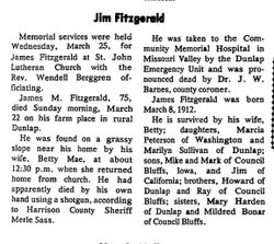
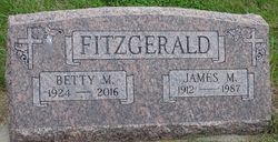
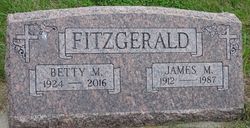
James Morris Fitzgerald
| Birth | : | 8 Mar 1912 Dunlap, Harrison County, Iowa, USA |
| Death | : | 22 Mar 1987 Dunlap, Harrison County, Iowa, USA |
| Burial | : | St. James Churchyard, Stanstead, Babergh District, England |
| Coordinate | : | 52.1116820, 0.6909100 |
| Plot | : | New Section, Block 6, Row 7 |
| Description | : | Married 25 may 1954 at Dunlap, Iowa to Betty Mae Bahr |
frequently asked questions (FAQ):
-
Where is James Morris Fitzgerald's memorial?
James Morris Fitzgerald's memorial is located at: St. James Churchyard, Stanstead, Babergh District, England.
-
When did James Morris Fitzgerald death?
James Morris Fitzgerald death on 22 Mar 1987 in Dunlap, Harrison County, Iowa, USA
-
Where are the coordinates of the James Morris Fitzgerald's memorial?
Latitude: 52.1116820
Longitude: 0.6909100
Family Members:
Parent
Spouse
Siblings
Flowers:
Nearby Cemetories:
1. St. James Churchyard
Stanstead, Babergh District, England
Coordinate: 52.1116820, 0.6909100
2. St Mary the Virgin Churchyard
Glemsford, Babergh District, England
Coordinate: 52.1033950, 0.6766070
3. Holy Trinity Churchyard
Boxted, Babergh District, England
Coordinate: 52.1223680, 0.6640480
4. Ebenezer Baptist Chapel Burial Ground
Glemsford, Babergh District, England
Coordinate: 52.0957000, 0.6680000
5. Hartest Cemetery
Hartest, Babergh District, England
Coordinate: 52.1387840, 0.6819620
6. Ss Peter & Paul Churchyard
Alpheton, Babergh District, England
Coordinate: 52.1207310, 0.7350230
7. All Saints Churchyard
Hartest, Babergh District, England
Coordinate: 52.1396780, 0.6793500
8. Holy Trinity Churchyard
Long Melford, Babergh District, England
Coordinate: 52.0877110, 0.7207640
9. Independent Chapel Cemetery
Long Melford, Babergh District, England
Coordinate: 52.0755010, 0.7157700
10. St. George and St. Gregory Churchyard
Pentlow, Braintree District, England
Coordinate: 52.0841020, 0.6441840
11. Ss Peter and Paul Churchyard
Foxearth, Braintree District, England
Coordinate: 52.0709200, 0.6763800
12. Liston Churchyard
Liston, Braintree District, England
Coordinate: 52.0703970, 0.7017420
13. St. Mary the Virgin Churchyard
Cavendish, St Edmundsbury Borough, England
Coordinate: 52.0873318, 0.6334569
14. Cavendish Cemetery
Cavendish, St Edmundsbury Borough, England
Coordinate: 52.0868470, 0.6310620
15. St Margaret Churchyard
Somerton, Babergh District, England
Coordinate: 52.1474540, 0.6454900
16. All Saints Churchyard
Lawshall, Babergh District, England
Coordinate: 52.1552780, 0.7239140
17. Brockley Baptist Chapel
Brockley, St Edmundsbury Borough, England
Coordinate: 52.1588990, 0.6650810
18. St. Mary's Churchyard
Hawkedon, St Edmundsbury Borough, England
Coordinate: 52.1457520, 0.6254000
19. Borley Parish Churchyard
Borley, Braintree District, England
Coordinate: 52.0551490, 0.6932870
20. All Saints Churchyard
Acton, Babergh District, England
Coordinate: 52.0729650, 0.7598490
21. St. Andrew's Churchyard
Brockley, St Edmundsbury Borough, England
Coordinate: 52.1675880, 0.6659170
22. Lavenham Cemetery
Lavenham, Babergh District, England
Coordinate: 52.1039670, 0.7883200
23. All Saints Church of Stansfield
Stansfield, St Edmundsbury Borough, England
Coordinate: 52.1422222, 0.6046667
24. Saint Peter and Saint Paul Churchyard
Lavenham, Babergh District, England
Coordinate: 52.1062530, 0.7917130

