

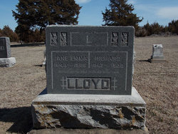
Jane Emma James Steward Lloyd
| Birth | : | 28 Apr 1843 Ludford, Shropshire Unitary Authority, Shropshire, England |
| Death | : | 13 Apr 1926 Clay County, Kansas, USA |
| Burial | : | Wesleyan Cemetery, Oak Hill, Clay County, USA |
| Coordinate | : | 39.2268982, -97.2572021 |
| Description | : | In the death of Mrs. Richard Lloyd, Clay County, Kansas, loses one of the earliest settlers of Exeter township. She was one of the real old-fashioned mothers who loved her home above everything else and her interest in life centered around her family circle. Her consideration for others, her genuine kindliness and sweetness of character will never be forgotten by her family or friends. She knew the joys and sorrows of life, having gone through the hardships of early days in Kansas with great fortitude and made the best of life, and now the hand of... Read More |
frequently asked questions (FAQ):
-
Where is Jane Emma James Steward Lloyd's memorial?
Jane Emma James Steward Lloyd's memorial is located at: Wesleyan Cemetery, Oak Hill, Clay County, USA.
-
When did Jane Emma James Steward Lloyd death?
Jane Emma James Steward Lloyd death on 13 Apr 1926 in Clay County, Kansas, USA
-
Where are the coordinates of the Jane Emma James Steward Lloyd's memorial?
Latitude: 39.2268982
Longitude: -97.2572021
Family Members:
Spouse
Children

Flowers:


Nearby Cemetories:
1. Wesleyan Cemetery
Oak Hill, Clay County, USA
Coordinate: 39.2268982, -97.2572021
2. Pleasant Valley Cemetery
Oak Hill, Clay County, USA
Coordinate: 39.2468987, -97.2889023
3. Rose Meron Cemetery
Oak Hill, Clay County, USA
Coordinate: 39.2194700, -97.3338900
4. Pleasant Ridge Cemetery
Clay County, USA
Coordinate: 39.2789001, -97.1841965
5. Athelstane Cemetery
Athelstane Township, Clay County, USA
Coordinate: 39.1768990, -97.1753006
6. Table Mound Cemetery
Idana, Clay County, USA
Coordinate: 39.3141300, -97.2792300
7. Hebron Cemetery
Clay County, USA
Coordinate: 39.3213800, -97.2601400
8. Zion Lutheran Cemetery
Clay County, USA
Coordinate: 39.2928009, -97.1557999
9. Mizpah Cemetery
Clay County, USA
Coordinate: 39.2057800, -97.1238500
10. Keystone Cemetery
Manchester, Dickinson County, USA
Coordinate: 39.1185989, -97.2917023
11. Swartwood Cemetery
Longford, Clay County, USA
Coordinate: 39.1323200, -97.3431500
12. Shields Cemetery
Clay County, USA
Coordinate: 39.3208008, -97.3507996
13. Uniondale Cemetery
Wakefield, Clay County, USA
Coordinate: 39.2382800, -97.0918400
14. Idana Cemetery
Idana, Clay County, USA
Coordinate: 39.3574500, -97.2693300
15. Republican City Cemetery
Clay Center, Clay County, USA
Coordinate: 39.3431015, -97.1628036
16. Greenridge Cemetery
Dickinson County, USA
Coordinate: 39.1199989, -97.1433029
17. Mount Liberty Church Cemetery
Ottawa County, USA
Coordinate: 39.2489400, -97.4356200
18. Saint John's Episcopal Cemetery
Clay County, USA
Coordinate: 39.2193985, -97.0744019
19. Henry Cemetery
Buckeye, Dickinson County, USA
Coordinate: 39.0828018, -97.1857986
20. Milo Chapman Gravesite
Broughton, Clay County, USA
Coordinate: 39.2888500, -97.0724400
21. Gilbert Cemetery
Clay County, USA
Coordinate: 39.2853012, -97.0625000
22. Wilson Cemetery
Clay County, USA
Coordinate: 39.3800011, -97.1896973
23. Vine Creek Cemetery
Ottawa County, USA
Coordinate: 39.1194000, -97.4180984
24. White Cloud Cemetery
Manchester, Dickinson County, USA
Coordinate: 39.0744019, -97.3525009