
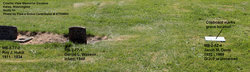
| Birth | : | 21 Feb 1832 Ohio, USA |
| Death | : | 11 Feb 1874 Humboldt, Richardson County, Nebraska, USA |
| Burial | : | Longbranch Cemetery, Humboldt, Richardson County, USA |
| Coordinate | : | 40.1996000, -95.9740000 |
| Plot | : | 220 |
| Inscription | : | Wife of Jacob Maxson Davis |
frequently asked questions (FAQ):
-
Where is Jane Sarah Furrow Davis's memorial?
Jane Sarah Furrow Davis's memorial is located at: Longbranch Cemetery, Humboldt, Richardson County, USA.
-
When did Jane Sarah Furrow Davis death?
Jane Sarah Furrow Davis death on 11 Feb 1874 in Humboldt, Richardson County, Nebraska, USA
-
Where are the coordinates of the Jane Sarah Furrow Davis's memorial?
Latitude: 40.1996000
Longitude: -95.9740000
Family Members:
Parent

Spouse
Siblings
Children
Flowers:


Nearby Cemetories:
1. Longbranch Cemetery
Humboldt, Richardson County, USA
Coordinate: 40.1996000, -95.9740000
2. Standerford Cemetery
Humboldt, Richardson County, USA
Coordinate: 40.2110000, -95.9656000
3. Humboldt Cemetery
Humboldt, Richardson County, USA
Coordinate: 40.1610985, -95.9578018
4. Bohemian Cemetery
Table Rock, Pawnee County, USA
Coordinate: 40.1786003, -96.0374985
5. Saint Johns Cemetery
Table Rock, Pawnee County, USA
Coordinate: 40.2148000, -96.0657000
6. Dry Branch Pioneer Cemetery
Richardson County, USA
Coordinate: 40.1292000, -96.0100021
7. Pleasant View Cemetery
Auburn, Nemaha County, USA
Coordinate: 40.2681007, -95.9163971
8. Mount Zion Cemetery
Nemaha County, USA
Coordinate: 40.2761002, -96.0113983
9. Saint James Lutheran Cemetery
Nemaha County, USA
Coordinate: 40.2757500, -96.0161500
10. Bohemian Cemetery
Richardson County, USA
Coordinate: 40.1175003, -95.9955978
11. Lynchburg Cemetery
Humboldt, Richardson County, USA
Coordinate: 40.1306000, -95.9068985
12. Mound Cemetery
Humboldt, Richardson County, USA
Coordinate: 40.1960983, -95.8602982
13. Starr Cemetery
Dawson, Richardson County, USA
Coordinate: 40.1464005, -95.8692017
14. Table Rock Cemetery
Table Rock, Pawnee County, USA
Coordinate: 40.1791400, -96.1037400
15. East Amish Cemetery
Table Rock, Pawnee County, USA
Coordinate: 40.1310000, -96.0854000
16. Trinity Lutheran Cemetery
Nemaha County, USA
Coordinate: 40.3058014, -96.0093994
17. Saint Marys Cemetery
Dawson, Richardson County, USA
Coordinate: 40.1307983, -95.8414001
18. Heim Cemetery
Dawson, Richardson County, USA
Coordinate: 40.1380997, -95.8328018
19. Clear Creek Cemetery
Table Rock, Pawnee County, USA
Coordinate: 40.2193985, -96.1391983
20. Saint Johns Lutheran Cemetery
Auburn, Nemaha County, USA
Coordinate: 40.3335000, -95.9576000
21. Martin Luther Church Cemetery
Nemaha County, USA
Coordinate: 40.3345040, -96.0098670
22. Four Mile Cemetery
Humboldt, Richardson County, USA
Coordinate: 40.0589000, -95.9455000
23. Beranek Cemetery
Table Rock, Pawnee County, USA
Coordinate: 40.2042007, -96.1607971
24. Howell Cemetery
Nemaha County, USA
Coordinate: 40.3008003, -95.8405991