
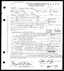
| Birth | : | 6 Oct 1931 Council Bluffs, Pottawattamie County, Iowa, USA |
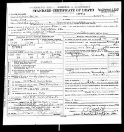
| Death | : | 11 Jan 2015 Council Bluffs, Pottawattamie County, Iowa, USA |
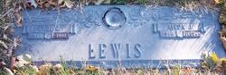
| Burial | : | Hardin Township Cemetery, McClelland, Pottawattamie County, USA |
| Coordinate | : | 41.2949982, -95.6513977 |
| Description | : | cutleroneill.com Jean Louise Burgstrum Casson Pearson October 6, 1931 - January 11, 2015 Obituary Jean Louise (Casson) Pearson, age 83, of Council Bluffs, entered into eternal rest on Sunday, January 11, 2015, in Council Bluffs. She was born October 6, 1931, in Council Bluffs, to Clifford and Mildred (Smith) Burgstrum. Jean was an admitting clerk for Jennie Edmundson Hospital for many years and a longtime teacher of ceramics and crafts. She was preceded in death by husbands, William Casson (1981) and Lester Pearson (2014); daughter, Billie Jean Casson; sister, Jane Lewis; and brother,... Read More |
frequently asked questions (FAQ):
-
Where is Jean Louise Burgstrum Pearson's memorial?
Jean Louise Burgstrum Pearson's memorial is located at: Hardin Township Cemetery, McClelland, Pottawattamie County, USA.
-
When did Jean Louise Burgstrum Pearson death?
Jean Louise Burgstrum Pearson death on 11 Jan 2015 in Council Bluffs, Pottawattamie County, Iowa, USA
-
Where are the coordinates of the Jean Louise Burgstrum Pearson's memorial?
Latitude: 41.2949982
Longitude: -95.6513977
Family Members:
Parent
Spouse

Siblings
Flowers:


Nearby Cemetories:
1. Hardin Township Cemetery
McClelland, Pottawattamie County, USA
Coordinate: 41.2949982, -95.6513977
2. Pottawattamie County Home Cemetery
McClelland, Pottawattamie County, USA
Coordinate: 41.3269400, -95.6691738
3. Saint Paul Lutheran Cemetery
Treynor, Pottawattamie County, USA
Coordinate: 41.2322000, -95.6380000
4. Downsville Cemetery
Pottawattamie County, USA
Coordinate: 41.3502998, -95.7039032
5. Zion Congregational Cemetery
Treynor, Pottawattamie County, USA
Coordinate: 41.2325090, -95.6079200
6. Fairview Pioneer Cemetery
Treynor, Pottawattamie County, USA
Coordinate: 41.2812843, -95.5555267
7. Saint Columbanus Cemetery
Weston, Pottawattamie County, USA
Coordinate: 41.3429440, -95.7435260
8. H G Fisher Cemetery
Underwood, Pottawattamie County, USA
Coordinate: 41.3838997, -95.6889038
9. Jones - Williams Cemetery
Pottawattamie County, USA
Coordinate: 41.3761000, -95.5846000
10. Stoker-Graybill Cemetery
Council Bluffs, Pottawattamie County, USA
Coordinate: 41.2532620, -95.7751770
11. Keg Creek Township Cemetery
Treynor, Pottawattamie County, USA
Coordinate: 41.1913986, -95.6893997
12. Garner Cemetery
Council Bluffs, Pottawattamie County, USA
Coordinate: 41.2956161, -95.8001709
13. Gregg Cemetery
Weston, Pottawattamie County, USA
Coordinate: 41.3330000, -95.7931000
14. Hazel Dell Cemetery
Council Bluffs, Pottawattamie County, USA
Coordinate: 41.3489723, -95.7939911
15. Castor Cemetery
Underwood, Pottawattamie County, USA
Coordinate: 41.4127040, -95.6887490
16. Cedar Lawn Cemetery
Council Bluffs, Pottawattamie County, USA
Coordinate: 41.2694016, -95.8182983
17. Saint Joseph Cemetery
Council Bluffs, Pottawattamie County, USA
Coordinate: 41.2722015, -95.8208008
18. Green Valley Cemetery
Council Bluffs, Pottawattamie County, USA
Coordinate: 41.2743988, -95.8225021
19. Zion Cemetery
Pottawattamie County, USA
Coordinate: 41.1778000, -95.7272000
20. Oak Hill Cemetery
Council Bluffs, Pottawattamie County, USA
Coordinate: 41.2700900, -95.8226400
21. Bikhor Cholim Cemetery
Council Bluffs, Pottawattamie County, USA
Coordinate: 41.2703670, -95.8229350
22. Walnut Hill Cemetery
Council Bluffs, Pottawattamie County, USA
Coordinate: 41.2719002, -95.8255997
23. Clark Cemetery
Pottawattamie County, USA
Coordinate: 41.2551610, -95.8223390
24. Ridgewood Cemetery
Council Bluffs, Pottawattamie County, USA
Coordinate: 41.2694016, -95.8272018