
| Birth | : | 11 Aug 1925 Pottawattamie County, Iowa, USA |
| Death | : | 3 Oct 2013 USA |
| Burial | : | Malvern Cemetery, Malvern, Mills County, USA |
| Coordinate | : | 40.9886017, -95.5785980 |
| Plot | : | Section 14 Lot 1 |
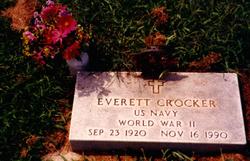
| Description | : | Jean was born on August 11, 1925 in Pottawatamie County, IA and passed away October 3, 2013. She graduated from Jennie Edmundsen School of Nursing in 1946 and enjoyed a life-long career in nursing. She married Everett Monroe Crocker on September 29, 1946 in Iowa and they raised five children. Jean married Marlin Lemonds in 1962. They made their home in Southwest Iowa where Marlin farmed. Jean's priority was her faith in Christ and she was very active in her church. She enjoyed spending time with her family, gardening, baking, and antiques. Jean is survived by her children, Susan Majerus, Thomas... Read More |
frequently asked questions (FAQ):
-
Where is Jean Louise Stuhr Crocker Lemonds's memorial?
Jean Louise Stuhr Crocker Lemonds's memorial is located at: Malvern Cemetery, Malvern, Mills County, USA.
-
When did Jean Louise Stuhr Crocker Lemonds death?
Jean Louise Stuhr Crocker Lemonds death on 3 Oct 2013 in USA
-
Where are the coordinates of the Jean Louise Stuhr Crocker Lemonds's memorial?
Latitude: 40.9886017
Longitude: -95.5785980
Family Members:

Spouse
Siblings
Flowers:


Nearby Cemetories:
1. Malvern Cemetery
Malvern, Mills County, USA
Coordinate: 40.9886017, -95.5785980
2. Parker Cemetery
White Cloud, Mills County, USA
Coordinate: 40.9737649, -95.5184363
3. Hillsdale Cemetery
Glenwood, Mills County, USA
Coordinate: 41.0097008, -95.6427994
4. Wearin Cemetery
Malvern, Mills County, USA
Coordinate: 41.0395000, -95.5313000
5. Hastings Cemetery
Hastings, Mills County, USA
Coordinate: 41.0097008, -95.4993973
6. South Grove Cemetery
Mills County, USA
Coordinate: 40.9775009, -95.4931030
7. East Liberty Cemetery
Malvern, Mills County, USA
Coordinate: 41.0592346, -95.6005020
8. Fairview Cemetery
Tabor, Mills County, USA
Coordinate: 40.9453011, -95.6716995
9. Mills County Farm Cemetery
Glenwood, Mills County, USA
Coordinate: 41.0417930, -95.6756530
10. North Grove Cemetery
Hastings, Mills County, USA
Coordinate: 41.0161018, -95.4618988
11. Bomar Family Cemetery
Mills County, USA
Coordinate: 41.0369400, -95.6941700
12. Cotten Cemetery
Mills County, USA
Coordinate: 41.0845000, -95.5167000
13. Estes Cemetery
Tabor, Mills County, USA
Coordinate: 40.9425011, -95.7080994
14. Randolph Cemetery
Randolph, Fremont County, USA
Coordinate: 40.8769493, -95.5695038
15. Tabor Cemetery
Tabor, Mills County, USA
Coordinate: 40.9035260, -95.6799460
16. Riverside Cemetery
Randolph, Fremont County, USA
Coordinate: 40.8806000, -95.5269012
17. Pottawattamie Chief Waubonsie Burial Site
Mills County, USA
Coordinate: 40.9236100, -95.7086100
18. Waubonsie Cemetery
Mills County, USA
Coordinate: 40.9451370, -95.7310791
19. Silver City Cemetery
Silver City, Mills County, USA
Coordinate: 41.1042442, -95.6380005
20. Glenwood Resource Center Cemetery
Glenwood, Mills County, USA
Coordinate: 41.0361720, -95.7338590
21. Wesley Chapel Cemetery
Henderson, Mills County, USA
Coordinate: 41.1019249, -95.4987793
22. Rhodes Cemetery
Tabor, Fremont County, USA
Coordinate: 40.9011002, -95.7097015
23. Saylers Farm Cemetery
Henderson, Mills County, USA
Coordinate: 41.1083300, -95.4919440
24. Emerson Cemetery
Emerson, Mills County, USA
Coordinate: 41.0325012, -95.4021988