
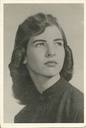
Jean Marguerite Carney DuRegger
| Birth | : | 11 May 1923 Long Beach, Los Angeles County, California, USA |
| Death | : | 19 Apr 1997 San Leandro, Alameda County, California, USA |
| Burial | : | Chapel of the Chimes Memorial Park, Hayward, Alameda County, USA |
| Coordinate | : | 37.6110992, -122.0222015 |
| Description | : | Jean Marguerite Carney Duregger AGE: 73 Jean Marguerite Duregger HAYWARD, Calif. Jean Marguerite (Carney) Duregger, 73, of Hayward, died Saturday (April 19, 1997) at Columbia San Leandro Hospital. Visitation will begin at 3 p.m. today at the Sorensen Bros, Mortuary, 1140 B St., Hayward, Calif. 94541. Funeral services will be held at 1:30 p.m. Wednesday at Calvary Lutheran Church, 17200 Via Magdalena, San Lorenzo. Entombment will follow at the Chapel of Chimes, Hayward. Friends are invited to a reception following at the Calvary Lutheran Church. Contributions in Jean's memory may be made to the American Cancer Society. Mrs. Duregger was born in Long Beach, but moved to Marble Rock, Iowa, where she was raised... Read More |
frequently asked questions (FAQ):
-
Where is Jean Marguerite Carney DuRegger's memorial?
Jean Marguerite Carney DuRegger's memorial is located at: Chapel of the Chimes Memorial Park, Hayward, Alameda County, USA.
-
When did Jean Marguerite Carney DuRegger death?
Jean Marguerite Carney DuRegger death on 19 Apr 1997 in San Leandro, Alameda County, California, USA
-
Where are the coordinates of the Jean Marguerite Carney DuRegger's memorial?
Latitude: 37.6110992
Longitude: -122.0222015
Family Members:

Spouse
Children
Flowers:


Nearby Cemetories:
1. Chapel of the Chimes Memorial Park
Hayward, Alameda County, USA
Coordinate: 37.6110992, -122.0222015
2. Garin Regional Park
Hayward, Alameda County, USA
Coordinate: 37.6365760, -122.0338690
3. Holy Sepulchre Cemetery
Hayward, Alameda County, USA
Coordinate: 37.6486588, -122.0647125
4. Centerville Pioneer Cemetery
Fremont, Alameda County, USA
Coordinate: 37.5596504, -122.0080643
5. Saint James Episcopal Church Columbarium
Fremont, Alameda County, USA
Coordinate: 37.5514440, -122.0171910
6. Holy Cross Orthodox Monastery Burial Site
Castro Valley, Alameda County, USA
Coordinate: 37.6331890, -121.9511560
7. Lone Tree Cemetery
Hayward, Alameda County, USA
Coordinate: 37.6747017, -122.0483017
8. Holy Ghost Cemetery
Fremont, Alameda County, USA
Coordinate: 37.5410995, -122.0132980
9. Mount Saint Joseph Cemetery
Hayward, Alameda County, USA
Coordinate: 37.6685028, -122.0760422
10. Mount Eden Cemetery
Hayward, Alameda County, USA
Coordinate: 37.6384000, -122.1105800
11. Irvington Memorial Cemetery
Fremont, Alameda County, USA
Coordinate: 37.5325012, -121.9653015
12. Ohlone Indians Cemetery
Fremont, Alameda County, USA
Coordinate: 37.5317001, -121.9344025
13. Dublin Cemetery
Dublin, Alameda County, USA
Coordinate: 37.6996040, -121.9384384
14. Mission San Jose Cemetery
Fremont, Alameda County, USA
Coordinate: 37.5338287, -121.9200745
15. Dominican Sisters of Mission San Jose Cemetery
Fremont, Alameda County, USA
Coordinate: 37.5342751, -121.9184265
16. San Lorenzo Pioneer Memorial Park
San Lorenzo, Alameda County, USA
Coordinate: 37.6901500, -122.1288500
17. Pleasanton Memorial Gardens Cemetery
Pleasanton, Alameda County, USA
Coordinate: 37.6466179, -121.8812256
18. Saint Augustines Cemetery
Pleasanton, Alameda County, USA
Coordinate: 37.6476250, -121.8811340
19. Saint Josephs Cemetery
Fremont, Alameda County, USA
Coordinate: 37.5172005, -121.9175034
20. County Cemetery
San Leandro, Alameda County, USA
Coordinate: 37.7165794, -122.1227798
21. Mount Calvary Cemetery
San Leandro, Alameda County, USA
Coordinate: 37.7178001, -122.1228027
22. Cedar Lawn Memorial Park
Fremont, Alameda County, USA
Coordinate: 37.4646988, -121.9131012
23. Saint Patricks Seminary Chapel Crypt
Menlo Park, San Mateo County, USA
Coordinate: 37.4595050, -122.1680330
24. First United Methodist Church Memorial Garden
Palo Alto, Santa Clara County, USA
Coordinate: 37.4493870, -122.1568630