

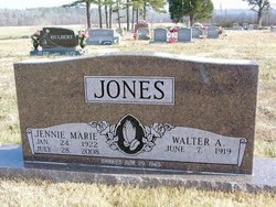
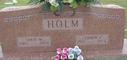
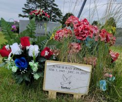
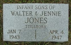
Jennie Marie Holm Jones
| Birth | : | 24 Jan 1922 Birch Tree, Shannon County, Missouri, USA |
| Death | : | 28 Jul 2008 West Plains, Howell County, Missouri, USA |
| Burial | : | Maple Grove Cemetery, Lancaster, Fairfield County, USA |
| Coordinate | : | 39.7266998, -82.5186005 |
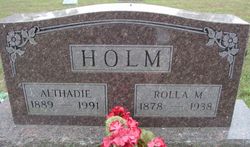
| Description | : | Jennie Marie Holm-Jones, 86, passed away July 28, 2008, at NHC of West Plains, Mo. She was born Jan. 24, 1922, to Rolla M. Holm and Althadia Bedford Holm at Birch Tree, Mo. Jennie was united in marriage June 29, 1940, to Walter Jones at Eminence, Mo. To this union two sons, Troyce Jones and Junior Jones, were born. Those left to mourn her passing, husband, Walter, of the home; sons, Troyce Jones, Douglas County, Mo., Junior Jones and wife, Toni, of Alton, Mo.; granddaughter, Julie Jones, Chapel Hill, N.C.; grandson, Michael Jones and wife, Wendy; two great-granddaughters, Kaitlin Marie and Karlie... Read More |
frequently asked questions (FAQ):
-
Where is Jennie Marie Holm Jones's memorial?
Jennie Marie Holm Jones's memorial is located at: Maple Grove Cemetery, Lancaster, Fairfield County, USA.
-
When did Jennie Marie Holm Jones death?
Jennie Marie Holm Jones death on 28 Jul 2008 in West Plains, Howell County, Missouri, USA
-
Where are the coordinates of the Jennie Marie Holm Jones's memorial?
Latitude: 39.7266998
Longitude: -82.5186005
Family Members:
Parent

Spouse
Siblings
Children

Flowers:


Nearby Cemetories:
1. Maple Grove Cemetery
Lancaster, Fairfield County, USA
Coordinate: 39.7266998, -82.5186005
2. Friesner Cemetery
Lancaster, Fairfield County, USA
Coordinate: 39.7252998, -82.5258026
3. Mount Tabor Cemetery
Fairfield County, USA
Coordinate: 39.7205000, -82.5174330
4. Bibler Cemetery
Fairfield County, USA
Coordinate: 39.7214012, -82.5081024
5. Amish Mennonite Cemetery
Lancaster, Fairfield County, USA
Coordinate: 39.7218610, -82.5035470
6. Casper Hufford Cemetery
Lancaster, Fairfield County, USA
Coordinate: 39.7196198, -82.4976425
7. Applegate Cemetery
Lancaster, Fairfield County, USA
Coordinate: 39.7202988, -82.5421982
8. Pleasant Hill United Methodist Cemetery
Pleasant Township, Fairfield County, USA
Coordinate: 39.7454830, -82.5303940
9. Saint Mathews Cemetery
Lancaster, Fairfield County, USA
Coordinate: 39.7461014, -82.5017014
10. Collins Chapel Cemetery
Fairfield County, USA
Coordinate: 39.7097015, -82.4961014
11. Asbury Cemetery
Lancaster, Fairfield County, USA
Coordinate: 39.7221985, -82.5558014
12. Grace Evangelical Lutheran Church Cemetery
Lancaster, Fairfield County, USA
Coordinate: 39.7491330, -82.4894720
13. Emanuel Lutheran Church Cemetery
Lancaster, Fairfield County, USA
Coordinate: 39.7497128, -82.5490379
14. Saint Paul Lutheran Cemetery
North Berne, Fairfield County, USA
Coordinate: 39.6913400, -82.5164000
15. Tent Church Cemetery
Lancaster, Fairfield County, USA
Coordinate: 39.7485929, -82.4819305
16. Huber Cemetery
Lancaster, Fairfield County, USA
Coordinate: 39.7407220, -82.5626840
17. Driver Cemetery
Bremen, Fairfield County, USA
Coordinate: 39.7144012, -82.4721985
18. Mount Zion Cemetery
Bremen, Fairfield County, USA
Coordinate: 39.7075005, -82.4666977
19. Sites-Sitz-Greenfiled-Ewing Cemetery
Lancaster, Fairfield County, USA
Coordinate: 39.7478828, -82.5699997
20. Baptist Corners Cemetery
Lancaster, Fairfield County, USA
Coordinate: 39.7732520, -82.5059350
21. Keller Cemetery
Fairfield County, USA
Coordinate: 39.7728060, -82.5377860
22. Lamott Cemetery
Fairfield County, USA
Coordinate: 39.6931590, -82.5743200
23. Pleasant Hill Cemetery
Berne Township, Fairfield County, USA
Coordinate: 39.6717239, -82.5084873
24. Fairfield County Infirmary Cemetery
Lancaster, Fairfield County, USA
Coordinate: 39.7388992, -82.5892029