

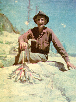

Jesse Leroy “Jess” Peck
| Birth | : | 9 Jul 1896 Des Moines, Polk County, Iowa, USA |
| Death | : | 6 Aug 1991 Manson, Chelan County, Washington, USA |
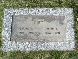
| Burial | : | Chelan Fraternal Cemetery, Chelan, Chelan County, USA |
| Coordinate | : | 47.8502998, -120.0081024 |
| Plot | : | South Fraternal Row6 STBLK7 L4A |
| Description | : | Jesse (Jess) L. Peck, 95, a long-time resident of Manson died Tuesday, August 6, 1991 at his home in Manson. Mr. Peck was born July 9, 1896 at Des Moines, Iowa the son of Henry and Emma (Scott) Peck. At the age of nine he moved with his family to Spokane where he later attended Lewis and Clark High School. Following a short tour of duty in the U.S. Army in 1918 he moved to the Lake Chelan area where he was employed with the Beebe Orchard Company. In 1920 he was married to Norma Gustin at Wenatchee. They moved... Read More |
frequently asked questions (FAQ):
-
Where is Jesse Leroy “Jess” Peck's memorial?
Jesse Leroy “Jess” Peck's memorial is located at: Chelan Fraternal Cemetery, Chelan, Chelan County, USA.
-
When did Jesse Leroy “Jess” Peck death?
Jesse Leroy “Jess” Peck death on 6 Aug 1991 in Manson, Chelan County, Washington, USA
-
Where are the coordinates of the Jesse Leroy “Jess” Peck's memorial?
Latitude: 47.8502998
Longitude: -120.0081024
Family Members:
Spouse
Children

Flowers:


Nearby Cemetories:
1. Chelan Fraternal Cemetery
Chelan, Chelan County, USA
Coordinate: 47.8502998, -120.0081024
2. Mount Olivet Cemetery
Chelan, Chelan County, USA
Coordinate: 47.8451000, -119.9946000
3. Saint Andrews Episcopal Church
Chelan, Chelan County, USA
Coordinate: 47.8397460, -120.0183780
4. Riverview Cemetery
Chelan, Chelan County, USA
Coordinate: 47.8335991, -119.9944000
5. Manson Indian Cemetery
Manson, Chelan County, USA
Coordinate: 47.8800000, -120.1300000
6. Ballard Family Cemetery
Stayman, Chelan County, USA
Coordinate: 47.7811100, -120.1133300
7. Fletcher Cemetery
Douglas County, USA
Coordinate: 47.7430992, -119.9403000
8. Brays Landing Cemetery
Douglas County, USA
Coordinate: 47.7364120, -120.1704660
9. Kummer Cemetery
Waterville, Douglas County, USA
Coordinate: 47.6559000, -120.0332000
10. Packwood Memorial Cemetery
Dyer, Douglas County, USA
Coordinate: 48.0118305, -119.8178880
11. Dick Family Cemetery
Okanogan County, USA
Coordinate: 48.0502700, -119.9241700
12. Miller Family Cemetery
Okanogan County, USA
Coordinate: 48.0530300, -119.9288000
13. Pateros Cemetery
Pateros, Okanogan County, USA
Coordinate: 48.0516600, -119.9097300
14. Waterville Cemetery
Waterville, Douglas County, USA
Coordinate: 47.6418500, -120.0685940
15. Gate of Heaven Catholic Cemetery
Waterville, Douglas County, USA
Coordinate: 47.6382100, -120.0671690
16. Douglas Lutheran Cemetery
Douglas County, USA
Coordinate: 47.6189003, -119.9614029
17. Badger Mountain View Cemetery
Douglas County, USA
Coordinate: 47.6088000, -120.0476000
18. Mansfield Cemetery
Mansfield, Douglas County, USA
Coordinate: 47.8088880, -119.6508330
19. Orondo Community Cemetery
Orondo, Douglas County, USA
Coordinate: 47.6486015, -120.2136002
20. Buckingham Cemetery
Douglas County, USA
Coordinate: 47.8669014, -119.6286011
21. Happy Home Cemetery
Farmer, Douglas County, USA
Coordinate: 47.6268997, -119.8125000
22. Methow Cemetery
Methow, Okanogan County, USA
Coordinate: 48.1102982, -120.0124969
23. Entiat Cemetery
Entiat, Chelan County, USA
Coordinate: 47.6755981, -120.3043976
24. Bridgeport Cemetery
Bridgeport, Douglas County, USA
Coordinate: 48.0050000, -119.6738800