
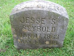
Jesse S. Seybold
| Birth | : | 17 Jan 1863 Gentry County, Missouri, USA |
| Death | : | 14 May 1915 Warrick County, Indiana, USA |
| Burial | : | Lake Of The Woods Cemetery, Kenora, Kenora District, Canada |
| Coordinate | : | 49.7764700, -94.4798500 |
| Description | : | Jesse S. Seybold, died Friday at his home in Newburgh. He leaves three children to whom he had ever been a sacrificing and devoted father - one daughter, Mrs. E.C. Reed of St. Louis, two sons, William of Henderson and Arthur M. of Newburgh. He was secretary of the school board, having been very faithful in these duties. He had just completed the assessing of the town. Funeral services were held Sunday afternoon at two o'clock at the M.E. church, Rev. B.A. May officiating. Interment at Rose Hill. |
frequently asked questions (FAQ):
-
Where is Jesse S. Seybold's memorial?
Jesse S. Seybold's memorial is located at: Lake Of The Woods Cemetery, Kenora, Kenora District, Canada.
-
When did Jesse S. Seybold death?
Jesse S. Seybold death on 14 May 1915 in Warrick County, Indiana, USA
-
Where are the coordinates of the Jesse S. Seybold's memorial?
Latitude: 49.7764700
Longitude: -94.4798500
Family Members:
Parent
Spouse
Children
Flowers:


Nearby Cemetories:
1. Lake Of The Woods Cemetery
Kenora, Kenora District, Canada
Coordinate: 49.7764700, -94.4798500
2. Pineridge Cemetery
Sioux Narrows, Kenora District, Canada
Coordinate: 49.3975171, -94.0623584
3. South East Whiteshell Cemetery
Falcon Lake, Eastern Manitoba Census Division, Canada
Coordinate: 49.7142730, -95.2546700
4. Fort Saint Charles Cemetery
Fort Saint Charles, Lake of the Woods County, USA
Coordinate: 49.3628400, -94.9807120
5. Good Shepherd Cemetery
Angle Inlet, Lake of the Woods County, USA
Coordinate: 49.3511110, -95.0822500
6. McIntosh First Nation Residential School Cemetery
McIntosh, Kenora District, Canada
Coordinate: 49.9794440, -93.6108330
7. McIntosh Cemetery
McIntosh, Kenora District, Canada
Coordinate: 49.9813175, -93.5870514
8. Vermilion Bay Catholic Cemetery
Vermilion Bay, Kenora District, Canada
Coordinate: 49.8782390, -93.4265730
9. Quibell Cemetery
Quibell, Kenora District, Canada
Coordinate: 49.9594491, -93.4252027
10. Norman Cottam Memorial Gardens
Nestor Falls, Kenora District, Canada
Coordinate: 49.1343810, -93.9210630
11. East Braintree Cemetery
East Braintree, Eastern Manitoba Census Division, Canada
Coordinate: 49.5985150, -95.6123610
12. Eagle River Cemetery
Eagle River, Kenora District, Canada
Coordinate: 49.7920670, -93.2036170
13. Saint Marys Riverside Cemetery
Prawda, Eastern Manitoba Census Division, Canada
Coordinate: 49.6903670, -95.7950330
14. Birch River Community Cemetery
Prawda, Eastern Manitoba Census Division, Canada
Coordinate: 49.7493580, -95.8491470
15. Minnitaki Cemetery
Minnitaki, Kenora District, Canada
Coordinate: 49.8157393, -93.0846587
16. Twin Rivers Mennonite Church Cemetery
Elma, Eastern Manitoba Census Division, Canada
Coordinate: 49.7973690, -95.8932610
17. Holy Cross Ukrainian Catholic Cemetery
Elma, Eastern Manitoba Census Division, Canada
Coordinate: 49.8742620, -95.9009350
18. Ukrainian Catholic Cemetery Ascension of Our Lord
Hadashville, Eastern Manitoba Census Division, Canada
Coordinate: 49.6945830, -95.9064670
19. St. Anthony of Padua Roman Catholic Cemetery
Elma, Eastern Manitoba Census Division, Canada
Coordinate: 49.8731000, -95.9073670
20. Saint John the Baptist Roman Catholic Cemetery
Hadashville, Eastern Manitoba Census Division, Canada
Coordinate: 49.6753170, -95.9071500
21. Prosper Township Cemetery
Birch Beach, Lake of the Woods County, USA
Coordinate: 48.8863450, -94.9375190
22. Hillside Cemetery
Lake of the Woods County, USA
Coordinate: 48.8436012, -94.8822021
23. Middlebro Community Cemetery
Middlebro, Eastern Manitoba Census Division, Canada
Coordinate: 49.0312000, -95.4318000
24. Stony Hill Cemetery
Stony Hill, Eastern Manitoba Census Division, Canada
Coordinate: 49.8688830, -95.9753670