
Jessie J Jefferis Dickinson
| Birth | : | 16 May 1910 Moran, Allen County, Kansas, USA |
| Death | : | 19 Feb 1994 Fort Scott, Bourbon County, Kansas, USA |
| Burial | : | Mountain View Cemetery, Moriarty, Torrance County, USA |
| Coordinate | : | 34.9977989, -106.0631027 |
| Plot | : | South Section, Block 5, Row 2, Lot 18, Plot 1 |
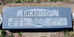
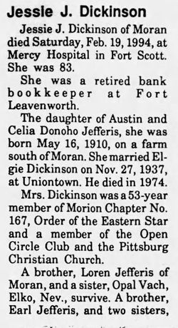
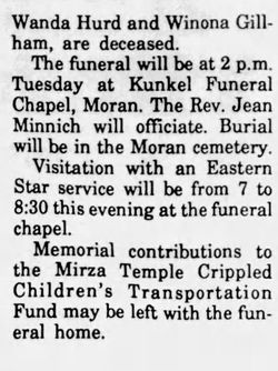
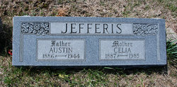
| Description | : | Jessie J. Dickinson was born May 16, 1910, on a farm south of Moran, the daughter of Austin and Celia Donoho Jefferis. Her husband, Elgie Dickinson, preceded her in death in 1974. She died Feb. 19, 1994, at Fort Scott Mercy Hospital. --Submitted by Fort Scott Girl |
frequently asked questions (FAQ):
-
Where is Jessie J Jefferis Dickinson's memorial?
Jessie J Jefferis Dickinson's memorial is located at: Mountain View Cemetery, Moriarty, Torrance County, USA.
-
When did Jessie J Jefferis Dickinson death?
Jessie J Jefferis Dickinson death on 19 Feb 1994 in Fort Scott, Bourbon County, Kansas, USA
-
Where are the coordinates of the Jessie J Jefferis Dickinson's memorial?
Latitude: 34.9977989
Longitude: -106.0631027
Family Members:
Parent

Spouse

Siblings

Flowers:


Nearby Cemetories:
1. Mountain View Cemetery
Moriarty, Torrance County, USA
Coordinate: 34.9977989, -106.0631027
2. Our Lady of Mount Carmel Cemetery
Moriarty, Torrance County, USA
Coordinate: 34.9900017, -106.0485992
3. Martinez Cemetery
Martinez, Torrance County, USA
Coordinate: 35.0000650, -106.1994560
4. McIntosh Cemetery
Torrance County, USA
Coordinate: 34.8647003, -106.0511017
5. Mountain Valley Cemetery
Edgewood, Santa Fe County, USA
Coordinate: 35.0760994, -106.2431030
6. Chilili New Cemetery
Chilili, Bernalillo County, USA
Coordinate: 34.8839800, -106.2229200
7. Saint John Nepomucene Cemetery
Torrance County, USA
Coordinate: 34.8894005, -106.2322006
8. Chilili Cemetery
Chilili, Bernalillo County, USA
Coordinate: 34.8894005, -106.2322006
9. San Juan Nepomoceno
Chilili, Bernalillo County, USA
Coordinate: 34.8893350, -106.2326730
10. La Morada Cemetery
Chilili, Bernalillo County, USA
Coordinate: 34.8891700, -106.2337160
11. Stanley Cemetery
Stanley, Santa Fe County, USA
Coordinate: 35.1599998, -105.9732971
12. Escabosa Cemetery
Escabosa, Bernalillo County, USA
Coordinate: 34.9253910, -106.2814520
13. Juan Tomas Cemetery
Juan Tomas, Bernalillo County, USA
Coordinate: 35.0273840, -106.3030600
14. Cedar Grove Cemetery
Santa Fe County, USA
Coordinate: 35.1707993, -106.1893997
15. San Isidro de Labrador Mission Church Cemetery
Sedillo, Bernalillo County, USA
Coordinate: 35.0997009, -106.2949982
16. Hyer Cemetery
Santa Fe County, USA
Coordinate: 35.2155991, -106.1371994
17. Cedro Cemetery
Bernalillo County, USA
Coordinate: 35.0239320, -106.3556420
18. Garland Cemetery
Torrance County, USA
Coordinate: 34.7972220, -106.2352780
19. Estancia Memorial Cemetery
Estancia, Torrance County, USA
Coordinate: 34.7406006, -106.0796967
20. Urban Family Ranch Cemetery
Estancia, Torrance County, USA
Coordinate: 34.7808126, -106.2597102
21. San Pedro Cemetery
Santa Fe County, USA
Coordinate: 35.2386017, -106.2181015
22. San Antonio Cemetery
Cedar Crest, Bernalillo County, USA
Coordinate: 35.1036030, -106.3767400
23. San Antonio Cemetery Annex
Cedar Crest, Bernalillo County, USA
Coordinate: 35.1051000, -106.3767190
24. Tijeras Cemetery
Tijeras, Bernalillo County, USA
Coordinate: 35.0760000, -106.3901000