
| Birth | : | 12 May 1944 Brown City, Sanilac County, Michigan, USA |
| Death | : | 27 Jul 1999 Milton, Cabell County, West Virginia, USA |
| Burial | : | Fleetwood Cemetery, Fleetwood, Wyre Borough, England |
| Coordinate | : | 53.9223440, -3.0370570 |
| Plot | : | Section F |
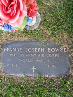
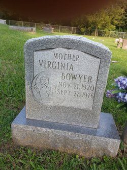
| Description | : | JO ANN WAS BORN TO JOSEPH AND VIRGINIA (PERRY) BOWYER. SHE WAS MARRIED TO LOUIS EARL WOODARD. JO ANN HAD FIVE LOVING CHILDREN AND NINE BEAUTIFUL GRANDCHILDREN.SHE WAS PRECEDED BY HER HUSBAND,LOUIS;DAUGHTER,KAREN; BOTH PARENTS;BROTHER,RICHARD;AND SISTER,SANDRA MEADOWS. |
frequently asked questions (FAQ):
-
Where is Jo Ann Bowyer Woodard's memorial?
Jo Ann Bowyer Woodard's memorial is located at: Fleetwood Cemetery, Fleetwood, Wyre Borough, England.
-
When did Jo Ann Bowyer Woodard death?
Jo Ann Bowyer Woodard death on 27 Jul 1999 in Milton, Cabell County, West Virginia, USA
-
Where are the coordinates of the Jo Ann Bowyer Woodard's memorial?
Latitude: 53.9223440
Longitude: -3.0370570
Family Members:
Parent
Spouse

Siblings
Children
Flowers:


Nearby Cemetories:
1. Fleetwood Cemetery
Fleetwood, Wyre Borough, England
Coordinate: 53.9223440, -3.0370570
2. St. Peter and St. David Churchyard
Fleetwood, Wyre Borough, England
Coordinate: 53.9238123, -3.0116212
3. Preesall Cemetery
Preesall, Wyre Borough, England
Coordinate: 53.9075410, -2.9635410
4. Christ Church Thornton Churchyard
Thornton-Cleveleys, Wyre Borough, England
Coordinate: 53.8772800, -3.0221100
5. St James Churchyard
Stalmine, Wyre Borough, England
Coordinate: 53.9020510, -2.9533720
6. All Hallow's Churchyard
Bispham, Blackpool Unitary Authority, England
Coordinate: 53.8567580, -3.0372160
7. St John the Baptist's Church
Pilling, Wyre Borough, England
Coordinate: 53.9289910, -2.9114540
8. St Johns Roman Catholic Church Cemetery
Poulton-le-Fylde, Wyre Borough, England
Coordinate: 53.8520854, -2.9873511
9. Blackpool Cemetery and Crematorium
Poulton-le-Fylde, Wyre Borough, England
Coordinate: 53.8465680, -3.0196600
10. Saint Chad Churchyard
Poulton-le-Fylde, Wyre Borough, England
Coordinate: 53.8471992, -2.9925005
11. St Stephen On-the-Cliffs Churchyard
Blackpool, Blackpool Unitary Authority, England
Coordinate: 53.8407230, -3.0515610
12. St William of York Church
Pilling, Wyre Borough, England
Coordinate: 53.9235047, -2.8934617
13. Poulton-Le-Fylde Old Cemetery
Poulton-le-Fylde, Wyre Borough, England
Coordinate: 53.8458145, -2.9713324
14. Poulton New Cemetery
Poulton-le-Fylde, Wyre Borough, England
Coordinate: 53.8461240, -2.9689560
15. Blackpool Jewish Cemetery
Blackpool, Blackpool Unitary Authority, England
Coordinate: 53.8287397, -3.0311753
16. St Paul's Church & Medical Centre
Blackpool Unitary Authority, England
Coordinate: 53.8291540, -3.0533490
17. Layton Cemetery
Blackpool, Blackpool Unitary Authority, England
Coordinate: 53.8273740, -3.0328240
18. St. John’s Churchyard
Out Rawcliffe, Wyre Borough, England
Coordinate: 53.8741650, -2.8959310
19. St. Anne's Churchyard
Blackburn, Blackburn with Darwen Unitary Authority, England
Coordinate: 53.8381160, -2.9362870
20. St Anne Churchyard
Singleton, Fylde Borough, England
Coordinate: 53.8379280, -2.9359890
21. St John the Evangelist Churchyard
Blackpool, Blackpool Unitary Authority, England
Coordinate: 53.8182303, -3.0508197
22. Carlton Cemetery& Crematorium
Blackpool, Blackpool Unitary Authority, England
Coordinate: 53.8095921, -3.0364920
23. St Anne Churchyard
Great Eccleston, Wyre Borough, England
Coordinate: 53.8481413, -2.8835925
24. Saint Paul Churchyard
Great Marton, Blackpool Unitary Authority, England
Coordinate: 53.8053220, -3.0268330