
| Memorials | : | 11 |
| Location | : | Pilling, Wyre Borough, England |
| Phone | : | 01253 790264 |
| Website | : | www.catholicdirectory.org/Catholic_Information.asp?ID=66159 |
| Coordinate | : | 53.9235047, -2.8934617 |
frequently asked questions (FAQ):
-
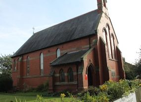
Where is St William of York Church?
St William of York Church is located at Garstang Road Pilling Lancashire Pilling, Wyre Borough ,Lancashire , PR3 6ALEngland.
-
St William of York Church cemetery's updated grave count on graveviews.com?
11 memorials
-
Where are the coordinates of the St William of York Church?
Latitude: 53.9235047
Longitude: -2.8934617
Nearby Cemetories:
1. St John the Baptist's Church
Pilling, Wyre Borough, England
Coordinate: 53.9289910, -2.9114540
2. St James Churchyard
Stalmine, Wyre Borough, England
Coordinate: 53.9020510, -2.9533720
3. Preesall Cemetery
Preesall, Wyre Borough, England
Coordinate: 53.9075410, -2.9635410
4. St. John’s Churchyard
Out Rawcliffe, Wyre Borough, England
Coordinate: 53.8741650, -2.8959310
5. Kirkland Strict and Particular Baptist Chapel
Nateby, Wyre Borough, England
Coordinate: 53.8961210, -2.8170130
6. Saint Michael's and All Angels Church Cemetery
Cockerham, City of Lancaster, England
Coordinate: 53.9602092, -2.8204877
7. St. Peter and St. David Churchyard
Fleetwood, Wyre Borough, England
Coordinate: 53.9238123, -3.0116212
8. St Mary Roman Catholic Churchyard
Great Eccleston, Wyre Borough, England
Coordinate: 53.8535420, -2.8710090
9. Garstang United Reformed Churchyard
Garstang, Wyre Borough, England
Coordinate: 53.9026500, -2.7747400
10. Forton United Reform Church Cemetery
Forton, Wyre Borough, England
Coordinate: 53.9547940, -2.7813920
11. St. Thomas Churchyard
Garstang, Wyre Borough, England
Coordinate: 53.8992300, -2.7764500
12. St Thomas with Elizabeth Churchyard
Thurnham, City of Lancaster, England
Coordinate: 53.9819990, -2.8159520
13. St. Michael’s Churchyard
St Michael's on Wyre, Wyre Borough, England
Coordinate: 53.8628050, -2.8195430
14. St. Helen's Churchyard
Kirkland (Churchtown), Wyre Borough, England
Coordinate: 53.8790700, -2.7901000
15. St Anne Churchyard
Great Eccleston, Wyre Borough, England
Coordinate: 53.8481413, -2.8835925
16. St Mary and St Michael Catholic Churchyard
Garstang, Wyre Borough, England
Coordinate: 53.8975610, -2.7706170
17. Christ Church of Glasson Churchyard
Glasson, City of Lancaster, England
Coordinate: 53.9966870, -2.8421460
18. St. Mary's Chapel Ellel Grange
Ellel, City of Lancaster, England
Coordinate: 53.9756944, -2.7918522
19. St. Peter's Churchyard
Garstang, Wyre Borough, England
Coordinate: 53.9309510, -2.7591190
20. St Paul's Churchyard
Forton, Wyre Borough, England
Coordinate: 53.9543760, -2.7605890
21. Fleetwood Cemetery
Fleetwood, Wyre Borough, England
Coordinate: 53.9223440, -3.0370570
22. Elswick Congregational Chapelyard
Elswick, Fylde Borough, England
Coordinate: 53.8378950, -2.8775320
23. Christ Church Thornton Churchyard
Thornton-Cleveleys, Wyre Borough, England
Coordinate: 53.8772800, -3.0221100
24. St. Anne's Churchyard
Blackburn, Blackburn with Darwen Unitary Authority, England
Coordinate: 53.8381160, -2.9362870