
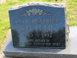
Joan Beatrice Frigon Stetler
| Birth | : | 11 Apr 1930 Aurora, Cloud County, Kansas, USA |
| Death | : | 5 Jul 1992 Bremerton, Kitsap County, Washington, USA |
| Burial | : | Rose Meron Cemetery, Oak Hill, Clay County, USA |
| Coordinate | : | 39.2194700, -97.3338900 |
| Description | : | Salina Journal – Jul. 10, 1992 Joan Beatrice Stetler PORT ORCHARD, Wash. — Joan Beatrice Stetler, 62, Port Orchard, died Sunday, July 5, 1992, at the Harrison Memorial Hospital, Bremerton. Mrs. Stetler was born Joan Beatrice Frigon on April 11, 1930, at Aurora, Kan., and was raised in the Aurora and Clifton, Kan., areas. She moved to Iowa in 1960 and to Port Orchard in 1982. She was a homemaker. Survivors include two sons, Greg of Port Orchard and Doug of Buffalo, N.Y.; two daughters, Jennifer Moore of Wilmington, N.C., and Janet Bin of Piano, Texas; her mother, Antoinette Frigon of Clifton; four brothers,... Read More |
frequently asked questions (FAQ):
-
Where is Joan Beatrice Frigon Stetler's memorial?
Joan Beatrice Frigon Stetler's memorial is located at: Rose Meron Cemetery, Oak Hill, Clay County, USA.
-
When did Joan Beatrice Frigon Stetler death?
Joan Beatrice Frigon Stetler death on 5 Jul 1992 in Bremerton, Kitsap County, Washington, USA
-
Where are the coordinates of the Joan Beatrice Frigon Stetler's memorial?
Latitude: 39.2194700
Longitude: -97.3338900
Family Members:
Parent

Siblings

Flowers:


Nearby Cemetories:
1. Rose Meron Cemetery
Oak Hill, Clay County, USA
Coordinate: 39.2194700, -97.3338900
2. Pleasant Valley Cemetery
Oak Hill, Clay County, USA
Coordinate: 39.2468987, -97.2889023
3. Wesleyan Cemetery
Oak Hill, Clay County, USA
Coordinate: 39.2268982, -97.2572021
4. Mount Liberty Church Cemetery
Ottawa County, USA
Coordinate: 39.2489400, -97.4356200
5. Swartwood Cemetery
Longford, Clay County, USA
Coordinate: 39.1323200, -97.3431500
6. Shields Cemetery
Clay County, USA
Coordinate: 39.3208008, -97.3507996
7. Table Mound Cemetery
Idana, Clay County, USA
Coordinate: 39.3141300, -97.2792300
8. Keystone Cemetery
Manchester, Dickinson County, USA
Coordinate: 39.1185989, -97.2917023
9. Hebron Cemetery
Clay County, USA
Coordinate: 39.3213800, -97.2601400
10. Vine Creek Cemetery
Ottawa County, USA
Coordinate: 39.1194000, -97.4180984
11. Athelstane Cemetery
Athelstane Township, Clay County, USA
Coordinate: 39.1768990, -97.1753006
12. Pleasant Ridge Cemetery
Clay County, USA
Coordinate: 39.2789001, -97.1841965
13. Miltonvale Cemetery
Miltonvale, Cloud County, USA
Coordinate: 39.3358002, -97.4447021
14. White Cloud Cemetery
Manchester, Dickinson County, USA
Coordinate: 39.0744019, -97.3525009
15. Idana Cemetery
Idana, Clay County, USA
Coordinate: 39.3574500, -97.2693300
16. Zion Lutheran Cemetery
Clay County, USA
Coordinate: 39.2928009, -97.1557999
17. Mizpah Cemetery
Clay County, USA
Coordinate: 39.2057800, -97.1238500
18. Smith Grave
Miltonvale, Cloud County, USA
Coordinate: 39.3645300, -97.4308700
19. Fairview Cemetery
Lamar, Ottawa County, USA
Coordinate: 39.2928009, -97.5299988
20. Ackley Cemetery
Ottawa County, USA
Coordinate: 39.0893160, -97.4797040
21. Greenridge Cemetery
Dickinson County, USA
Coordinate: 39.1199989, -97.1433029
22. Henry Cemetery
Buckeye, Dickinson County, USA
Coordinate: 39.0828018, -97.1857986
23. Prairiedale Cemetery
Talmage, Dickinson County, USA
Coordinate: 39.0471992, -97.2652969
24. Republican City Cemetery
Clay Center, Clay County, USA
Coordinate: 39.3431015, -97.1628036