
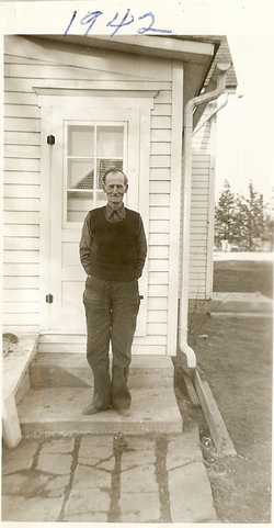

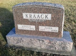
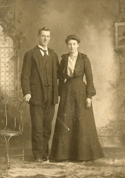
Johann (John) Frederick William Kraack Jr.
| Birth | : | 23 Sep 1877 Sterling, Whiteside County, Illinois, USA |
| Death | : | 12 Mar 1952 Redfield, Dallas County, Iowa, USA |
| Burial | : | Louth Cemetery, Louth, East Lindsey District, England |
| Coordinate | : | 53.3604820, -0.0038070 |
| Plot | : | Sec C Lot 83 space 2 |
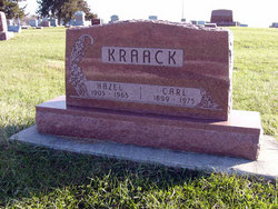
| Description | : | His full name was Johann (John) Frederick William Kraack Jr. B 9-23-1877 in Sterling, Whiteside County, Illinois D 3-12-1952 at his home in Redfield, Dallas County, Iowa. He was married to Amalia (Mollie) Fredrika Onken in 1898. They had two sons, Carl Kraack and Donald Harley Kraack. |
frequently asked questions (FAQ):
-
Where is Johann (John) Frederick William Kraack Jr.'s memorial?
Johann (John) Frederick William Kraack Jr.'s memorial is located at: Louth Cemetery, Louth, East Lindsey District, England.
-
When did Johann (John) Frederick William Kraack Jr. death?
Johann (John) Frederick William Kraack Jr. death on 12 Mar 1952 in Redfield, Dallas County, Iowa, USA
-
Where are the coordinates of the Johann (John) Frederick William Kraack Jr.'s memorial?
Latitude: 53.3604820
Longitude: -0.0038070
Family Members:
Spouse
Children
Flowers:


Nearby Cemetories:
1. Louth Cemetery
Louth, East Lindsey District, England
Coordinate: 53.3604820, -0.0038070
2. St. James Churchyard
Louth, East Lindsey District, England
Coordinate: 53.3666730, -0.0080358
3. Louth Abbey
Louth, East Lindsey District, England
Coordinate: 53.3666840, -0.0080750
4. Saint Mary's Old Cemetery
Louth, East Lindsey District, England
Coordinate: 53.3679040, -0.0100780
5. Priory Cottage, Eastgate
Louth, East Lindsey District, England
Coordinate: 53.3679743, 0.0029732
6. Holy Trinity Church Cemetery
Louth, East Lindsey District, England
Coordinate: 53.3691600, 0.0071900
7. St. Margaret Churchyard
Keddington, East Lindsey District, England
Coordinate: 53.3777150, 0.0203370
8. All Saints Churchyard
Legbourne, East Lindsey District, England
Coordinate: 53.3390478, -0.0525820
9. St. Helen's Churchyard
Little Cawthorpe, East Lindsey District, England
Coordinate: 53.3332700, 0.0363400
10. St Helen's Churchyard
Little Cawthorpe, East Lindsey District, England
Coordinate: 53.3332300, 0.0363000
11. St Edith's Churchyard
Little Grimsby, East Lindsey District, England
Coordinate: 53.4020500, -0.0062550
12. St. Mary Churchyard
Fotherby, East Lindsey District, England
Coordinate: 53.4057520, -0.0204600
13. All Saints Churchyard
Haugham, East Lindsey District, England
Coordinate: 53.3127100, 0.0033400
14. St Adelwold Churchyard
Alvingham, East Lindsey District, England
Coordinate: 53.4009600, 0.0560600
15. St Edith Churchyard
Grimoldby, East Lindsey District, England
Coordinate: 53.3700890, 0.0919330
16. St. Michael's Churchyard
Burwell, East Lindsey District, England
Coordinate: 53.2968800, 0.0325800
17. St. Mary’s Churchyard
Covenham St Mary, East Lindsey District, England
Coordinate: 53.4292484, 0.0147001
18. St Bartholomew Churchyard
Covenham St Bartholomew, East Lindsey District, England
Coordinate: 53.4307280, 0.0140490
19. St John the Baptist Churchyard
Great Carlton, East Lindsey District, England
Coordinate: 53.3481180, 0.1138540
20. St Faith Church
Kelstern, East Lindsey District, England
Coordinate: 53.3911200, -0.1196310
21. St. Peter's Churchyard
Gayton le Wold, East Lindsey District, England
Coordinate: 53.3562320, -0.1431270
22. St Marys Churchyard
Ludborough, East Lindsey District, England
Coordinate: 53.4405106, -0.0510651
23. St. Peter's Churchyard
Asterby, East Lindsey District, England
Coordinate: 53.2975600, -0.1050000
24. St Georges Churchyard
Gayton le Marsh, East Lindsey District, England
Coordinate: 53.3349200, 0.1386000