
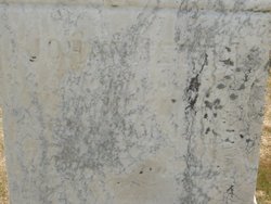

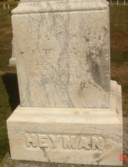
Johannetta Mohr Heyman
| Birth | : | 2 Jul 1833 Holzheim, Rhein-Lahn-Kreis, Rheinland-Pfalz, Germany |
| Death | : | 29 Mar 1875 Ohio, USA |
| Burial | : | Haycombe Cemetery and Crematorium, Bath, Bath and North East Somerset Unitary Authority, England |
| Coordinate | : | 51.3703430, -2.4014760 |
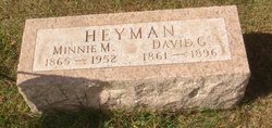
| Description | : | Johannetta was the daughter of Conrad and Marie Clara Henrietta (Scheid) Mohr. She emigrated with her parents to the United States in about 1851. They settled on a farm in Sherman Twp., Huron Co., Ohio On December 15, 1853, Johannetta and William Anton Heyman married. They first lived on a farm in Lyme Twp. and then moved to a larger farm in Sherman Twp. Together they had 15 children: Mary (b. 1854) Louisa (b. 1856) Emilie (b. 1857) Charles (b. 1858) Sarah (b. 1860) David (b. 1860) Adam (b. 1862) Benjamin F. (b. 1863) Isaac (b. 1865) Henry (b. 1866) William P. (b. 1867) Henry (b. 1868) Isaac (b. 1870) Jacob (b. 1871) Clara (b. 1873) Source:... Read More |
frequently asked questions (FAQ):
-
Where is Johannetta Mohr Heyman's memorial?
Johannetta Mohr Heyman's memorial is located at: Haycombe Cemetery and Crematorium, Bath, Bath and North East Somerset Unitary Authority, England.
-
When did Johannetta Mohr Heyman death?
Johannetta Mohr Heyman death on 29 Mar 1875 in Ohio, USA
-
Where are the coordinates of the Johannetta Mohr Heyman's memorial?
Latitude: 51.3703430
Longitude: -2.4014760
Family Members:
Parent
Spouse
Siblings

Children

Flowers:


Nearby Cemetories:
1. Haycombe Cemetery and Crematorium
Bath, Bath and North East Somerset Unitary Authority, England
Coordinate: 51.3703430, -2.4014760
2. St Peter Churchyard
Englishcombe, Bath and North East Somerset Unitary Authority, England
Coordinate: 51.3640600, -2.4088700
3. St Michael and All Angels Churchyard
Twerton, Bath and North East Somerset Unitary Authority, England
Coordinate: 51.3809000, -2.3981000
4. Twerton Cemetery
Twerton, Bath and North East Somerset Unitary Authority, England
Coordinate: 51.3802500, -2.3836220
5. Locksbrook Cemetery
Lower Weston, Bath and North East Somerset Unitary Authority, England
Coordinate: 51.3845180, -2.3850300
6. Locksbrook St Saviour's Cemetery
Bath and North East Somerset Unitary Authority, England
Coordinate: 51.3867880, -2.3863380
7. St. Michael's Cemetery
Bath, Bath and North East Somerset Unitary Authority, England
Coordinate: 51.3859700, -2.3814500
8. Bath Union Workhouse Burial Ground
Bath, Bath and North East Somerset Unitary Authority, England
Coordinate: 51.3570889, -2.3773370
9. St. James' Cemetery
Bath, Bath and North East Somerset Unitary Authority, England
Coordinate: 51.3802000, -2.3722200
10. Holy Trinity Churchyard
Newton St Loe, Bath and North East Somerset Unitary Authority, England
Coordinate: 51.3820470, -2.4311300
11. Bath Union Workhouse Graveyard
Bath, Bath and North East Somerset Unitary Authority, England
Coordinate: 51.3584160, -2.3711140
12. Moravian Burial Ground
Bath, Bath and North East Somerset Unitary Authority, England
Coordinate: 51.3894150, -2.3798150
13. St Mary Magdalen Chapel
Widcombe, Bath and North East Somerset Unitary Authority, England
Coordinate: 51.3760486, -2.3643405
14. St Mary's Chapel, Queens Square
Bath, Bath and North East Somerset Unitary Authority, England
Coordinate: 51.3827790, -2.3649790
15. All Saints Churchyard
Weston, Bath and North East Somerset Unitary Authority, England
Coordinate: 51.3956850, -2.3881320
16. St James Old Burial Ground
Bath, Bath and North East Somerset Unitary Authority, England
Coordinate: 51.3798600, -2.3610100
17. Countess of Huntingdon's Chapel
Walcot, Bath and North East Somerset Unitary Authority, England
Coordinate: 51.3967020, -2.3907434
18. Saint Mark's Churchyard
Widcombe, Bath and North East Somerset Unitary Authority, England
Coordinate: 51.3766660, -2.3588010
19. Bath General Hospital Burial Ground
Bath and North East Somerset Unitary Authority, England
Coordinate: 51.3824715, -2.3614742
20. St. Mary de Stall Churchyard (Defunct)
Bath, Bath and North East Somerset Unitary Authority, England
Coordinate: 51.3813350, -2.3600353
21. Quaker Meeting House
Bath, Bath and North East Somerset Unitary Authority, England
Coordinate: 51.3823280, -2.3604380
22. All Saints Churchyard
Corston, Bath and North East Somerset Unitary Authority, England
Coordinate: 51.3857350, -2.4400372
23. Old Orchard Street Catholic Burial Vault
Bath, Bath and North East Somerset Unitary Authority, England
Coordinate: 51.3800370, -2.3579910
24. Bath Abbey
Bath, Bath and North East Somerset Unitary Authority, England
Coordinate: 51.3815310, -2.3586640