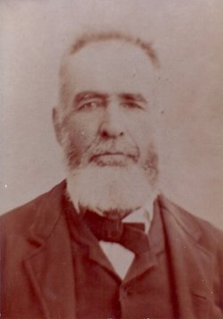
John Adams Monroe
| Birth | : | 1 Apr 1835 Shelby County, Indiana, USA |
| Death | : | 18 Feb 1928 Plattsmouth, Cass County, Nebraska, USA |
| Burial | : | St James The Great Churchyard, Fulbrook, West Oxfordshire District, England |
| Coordinate | : | 51.8153500, -1.6265430 |
| Plot | : | Section 1A; Lot 588; Grave 7. |
| Inscription | : | 12 MO Cavalry Co. C |
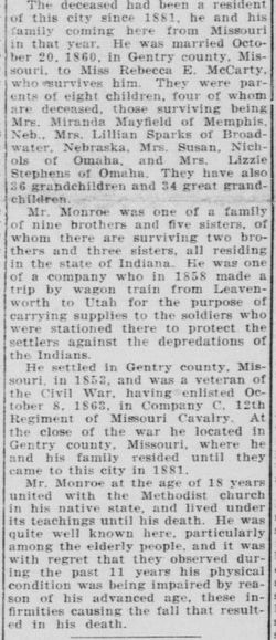
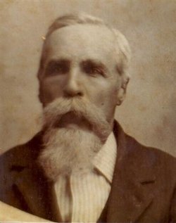
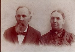
| Description | : | The Nebraska Teacher December 1920, page 172 Current Events John Adams Monroe of Plattsmouth is 86 years old and came to Nebraska in 1857. He is a member of an old New England family. There were nine sons in the family and they were named after the early presidents and other leading statesmen. There were Andrew Jackson Monroe, James Madison Monroe, Thomas Jefferson Monroe, and others. Mr. Monroe lives in the house where Peter A. Sarpy died and his collections of early Nebraska are among the most interesting. Contributor: Becky Martin (47418636) • ====================================================== The... Read More |
frequently asked questions (FAQ):
-
Where is John Adams Monroe's memorial?
John Adams Monroe's memorial is located at: St James The Great Churchyard, Fulbrook, West Oxfordshire District, England.
-
When did John Adams Monroe death?
John Adams Monroe death on 18 Feb 1928 in Plattsmouth, Cass County, Nebraska, USA
-
Where are the coordinates of the John Adams Monroe's memorial?
Latitude: 51.8153500
Longitude: -1.6265430
Family Members:
Parent
Spouse
Siblings
Children
Flowers:
Nearby Cemetories:
1. St James The Great Churchyard
Fulbrook, West Oxfordshire District, England
Coordinate: 51.8153500, -1.6265430
2. St. John the Baptist Churchyard
Burford, West Oxfordshire District, England
Coordinate: 51.8096490, -1.6341730
3. Baptist Burial Ground
Burford, West Oxfordshire District, England
Coordinate: 51.8070150, -1.6338030
4. Burford Cemetery
Burford, West Oxfordshire District, England
Coordinate: 51.8084000, -1.6489600
5. St Oswald's Churchyard
Widford, West Oxfordshire District, England
Coordinate: 51.8067780, -1.6047160
6. St Mary Churchyard
Swinbrook, West Oxfordshire District, England
Coordinate: 51.8072090, -1.5954540
7. St. John The Evangelist Churchyard
Taynton, West Oxfordshire District, England
Coordinate: 51.8216040, -1.6621950
8. St Nicholas Parish Church
Asthall, West Oxfordshire District, England
Coordinate: 51.8003600, -1.5850500
9. St. Mary's Churchyard
Westwell, West Oxfordshire District, England
Coordinate: 51.7886840, -1.6779678
10. Holy Rood Churchyard
Shilton, West Oxfordshire District, England
Coordinate: 51.7726519, -1.6142058
11. Holy Trinity Church
Witney, West Oxfordshire District, England
Coordinate: 51.7726500, -1.6142050
12. St. Peter's Churchyard
Little Barrington, Cotswold District, England
Coordinate: 51.8130930, -1.6983770
13. Saint Mary the Virgin Churchyard and Vaults
Shipton-under-Wychwood, West Oxfordshire District, England
Coordinate: 51.8597520, -1.5952810
14. Milton-under-Wychwood Friends Burial Ground
Milton-under-Wychwood, West Oxfordshire District, England
Coordinate: 51.8638040, -1.6109590
15. St. Simon-St. Jude
Milton-under-Wychwood, West Oxfordshire District, England
Coordinate: 51.8660230, -1.6170140
16. Milton-under-Wychwood Cemetery
Milton-under-Wychwood, West Oxfordshire District, England
Coordinate: 51.8684380, -1.6176370
17. Saint John the Baptist Church
Fifield, West Oxfordshire District, England
Coordinate: 51.8668460, -1.6536260
18. Saint Michaels and All Angels Churchyard
Leafield, West Oxfordshire District, England
Coordinate: 51.8355550, -1.5390810
19. Saint Kenelm's Churchyard
Minster Lovell, West Oxfordshire District, England
Coordinate: 51.8000620, -1.5314550
20. St. Britius Churchyard
Brize Norton, West Oxfordshire District, England
Coordinate: 51.7662000, -1.5667000
21. St. Britius Churchyard Extension
Brize Norton, West Oxfordshire District, England
Coordinate: 51.7660800, -1.5662600
22. Holy Trinity Churchyard
Ascott under Wychwood, West Oxfordshire District, England
Coordinate: 51.8660100, -1.5644700
23. St Nicholas Churchyard
Idbury, West Oxfordshire District, England
Coordinate: 51.8784370, -1.6584080
24. St. John the Baptist Churchyard
Great Rissington, Cotswold District, England
Coordinate: 51.8526130, -1.7180490

