
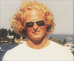
John Burlingame
| Birth | : | 19 Apr 1955 Manhattan, Riley County, Kansas, USA |
| Death | : | 19 Feb 2022 |
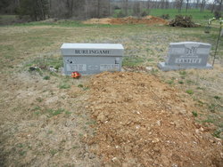
| Burial | : | Allen Cemetery, Olean, Miller County, USA |
| Coordinate | : | 38.4150009, -92.5008011 |
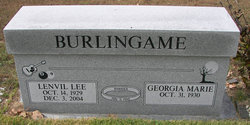
| Description | : | John Burlingame April 19, 1955 ~ February 19, 2022 John's soul left his body on this day, Saturday, February 19, 2022. He was born April 19, 1955 in Manhattan, Kansas, the son of the late Lenvil and Georgia (Procter) Burlingame. His life's journey began in high school (Hickman Class of 1973) when he started working for North American Van Lines. Fred, John's boss kept asking him when he was going to get "that license?" John replied, "soon Fred." John did get "that license" soon and Fred put John in a semi and... Read More |
frequently asked questions (FAQ):
-
Where is John Burlingame's memorial?
John Burlingame's memorial is located at: Allen Cemetery, Olean, Miller County, USA.
-
When did John Burlingame death?
John Burlingame death on 19 Feb 2022 in
-
Where are the coordinates of the John Burlingame's memorial?
Latitude: 38.4150009
Longitude: -92.5008011
Family Members:
Parent
Flowers:


Nearby Cemetories:
1. Allen Cemetery
Olean, Miller County, USA
Coordinate: 38.4150009, -92.5008011
2. Olean Cemetery
Olean, Miller County, USA
Coordinate: 38.4131012, -92.5413971
3. Farris Cemetery
Moniteau County, USA
Coordinate: 38.4369900, -92.5380000
4. Jackson Chapel Methodist Church Cemetery
California, Moniteau County, USA
Coordinate: 38.4447900, -92.5286500
5. Walker Cemetery
Moniteau County, USA
Coordinate: 38.4338989, -92.5522003
6. Etter-Walker Cemetery
Burris Fork, Moniteau County, USA
Coordinate: 38.4333700, -92.5525400
7. Green Ridge Baptist Church Cemetery
Eldon, Miller County, USA
Coordinate: 38.4116200, -92.5645700
8. Gray Cemetery
Moniteau County, USA
Coordinate: 38.4536018, -92.5456009
9. Bruce-Lewis-McGahan Cemetery
Enon, Moniteau County, USA
Coordinate: 38.4667500, -92.5172100
10. Rock Enon Cemetery
Miller County, USA
Coordinate: 38.4668400, -92.5170700
11. Mount Pleasant Cemetery
Eldon, Miller County, USA
Coordinate: 38.3667700, -92.5300800
12. Matheis Cemetery
Russellville, Cole County, USA
Coordinate: 38.4571800, -92.4491600
13. Mount Vernon Cemetery
Eldon, Miller County, USA
Coordinate: 38.3624992, -92.5606003
14. Salem Cemetery
Saline Township, Miller County, USA
Coordinate: 38.3691232, -92.5697260
15. Salem Cemetery
Eldon, Miller County, USA
Coordinate: 38.3697014, -92.5714035
16. Hite Cemetery
Miller County, USA
Coordinate: 38.4039001, -92.5935974
17. Spring Garden Cemetery
Spring Garden, Miller County, USA
Coordinate: 38.3922005, -92.4111023
18. Enon Cemetery
Russellville, Cole County, USA
Coordinate: 38.4888992, -92.4730988
19. Roark Cemetery
Russellville, Cole County, USA
Coordinate: 38.4696999, -92.4255981
20. Karnes-Carney-Henderson Cemetery
Burris Fork, Moniteau County, USA
Coordinate: 38.4992100, -92.5007510
21. Eldon Cemetery
Eldon, Miller County, USA
Coordinate: 38.3642006, -92.5868988
22. Belleville Cemetery
Russellville, Cole County, USA
Coordinate: 38.4970490, -92.4667150
23. Campbell Cemetery
Cole County, USA
Coordinate: 38.4810982, -92.4297028
24. Farmer Cemetery
Hickory Hill, Cole County, USA
Coordinate: 38.4143500, -92.3889790