
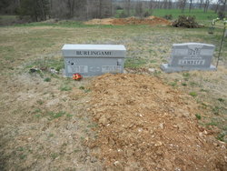
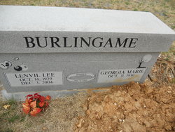
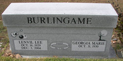
Georgia Marie Procter Burlingame
| Birth | : | 31 Oct 1930 |
| Death | : | 18 Mar 2013 Columbia, Boone County, Missouri, USA |
| Burial | : | Allen Cemetery, Olean, Miller County, USA |
| Coordinate | : | 38.4150009, -92.5008011 |
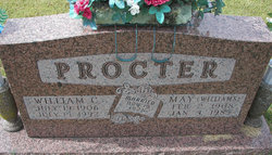
| Description | : | Mid-Missouri Newspaper, March, 2013 Georgia Burlingame, 82, of Columbia died Monday, March 13, 2013. Born October 31, 1930, to Bill and May Procter, she is survived by her four siblings, Bill Procter, Jim Procter, Barbara Jenkins and Frank Procter; her five children: Cheryl Burlingame, Rodney Burlingame, Janet Waldron, John Burlingame and Gina White; five grandchildren and five great-grandchildren. She was preceded in death by one grand-child. As a nurse, Mrs. Burlingame retired from Mid-Missouri Mental Health Center in 1990, after over 20 years of service. Visitation will be held at 1 p.m. followed by services at 2 p.m.... Read More |
frequently asked questions (FAQ):
-
Where is Georgia Marie Procter Burlingame's memorial?
Georgia Marie Procter Burlingame's memorial is located at: Allen Cemetery, Olean, Miller County, USA.
-
When did Georgia Marie Procter Burlingame death?
Georgia Marie Procter Burlingame death on 18 Mar 2013 in Columbia, Boone County, Missouri, USA
-
Where are the coordinates of the Georgia Marie Procter Burlingame's memorial?
Latitude: 38.4150009
Longitude: -92.5008011
Family Members:
Parent

Spouse
Siblings

Children

Flowers:


Nearby Cemetories:
1. Allen Cemetery
Olean, Miller County, USA
Coordinate: 38.4150009, -92.5008011
2. Olean Cemetery
Olean, Miller County, USA
Coordinate: 38.4131012, -92.5413971
3. Farris Cemetery
Moniteau County, USA
Coordinate: 38.4369900, -92.5380000
4. Jackson Chapel Methodist Church Cemetery
California, Moniteau County, USA
Coordinate: 38.4447900, -92.5286500
5. Walker Cemetery
Moniteau County, USA
Coordinate: 38.4338989, -92.5522003
6. Etter-Walker Cemetery
Burris Fork, Moniteau County, USA
Coordinate: 38.4333700, -92.5525400
7. Green Ridge Baptist Church Cemetery
Eldon, Miller County, USA
Coordinate: 38.4116200, -92.5645700
8. Gray Cemetery
Moniteau County, USA
Coordinate: 38.4536018, -92.5456009
9. Bruce-Lewis-McGahan Cemetery
Enon, Moniteau County, USA
Coordinate: 38.4667500, -92.5172100
10. Rock Enon Cemetery
Miller County, USA
Coordinate: 38.4668400, -92.5170700
11. Mount Pleasant Cemetery
Eldon, Miller County, USA
Coordinate: 38.3667700, -92.5300800
12. Matheis Cemetery
Russellville, Cole County, USA
Coordinate: 38.4571800, -92.4491600
13. Mount Vernon Cemetery
Eldon, Miller County, USA
Coordinate: 38.3624992, -92.5606003
14. Salem Cemetery
Saline Township, Miller County, USA
Coordinate: 38.3691232, -92.5697260
15. Salem Cemetery
Eldon, Miller County, USA
Coordinate: 38.3697014, -92.5714035
16. Hite Cemetery
Miller County, USA
Coordinate: 38.4039001, -92.5935974
17. Spring Garden Cemetery
Spring Garden, Miller County, USA
Coordinate: 38.3922005, -92.4111023
18. Enon Cemetery
Russellville, Cole County, USA
Coordinate: 38.4888992, -92.4730988
19. Roark Cemetery
Russellville, Cole County, USA
Coordinate: 38.4696999, -92.4255981
20. Karnes-Carney-Henderson Cemetery
Burris Fork, Moniteau County, USA
Coordinate: 38.4992100, -92.5007510
21. Eldon Cemetery
Eldon, Miller County, USA
Coordinate: 38.3642006, -92.5868988
22. Belleville Cemetery
Russellville, Cole County, USA
Coordinate: 38.4970490, -92.4667150
23. Campbell Cemetery
Cole County, USA
Coordinate: 38.4810982, -92.4297028
24. Farmer Cemetery
Hickory Hill, Cole County, USA
Coordinate: 38.4143500, -92.3889790