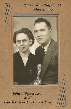
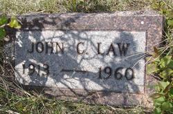
John Clifford Law
| Birth | : | 8 Jul 1913 Faith, Meade County, South Dakota, USA |
| Death | : | 17 Sep 1960 Sidney, Richland County, Montana, USA |
| Burial | : | White Earth Cemetery, White Earth, Mountrail County, USA |
| Coordinate | : | 48.3718987, -102.7639008 |
frequently asked questions (FAQ):
-
Where is John Clifford Law's memorial?
John Clifford Law's memorial is located at: White Earth Cemetery, White Earth, Mountrail County, USA.
-
When did John Clifford Law death?
John Clifford Law death on 17 Sep 1960 in Sidney, Richland County, Montana, USA
-
Where are the coordinates of the John Clifford Law's memorial?
Latitude: 48.3718987
Longitude: -102.7639008
Family Members:
Parent
Spouse
Siblings
Flowers:
Nearby Cemetories:
1. White Earth Cemetery
White Earth, Mountrail County, USA
Coordinate: 48.3718987, -102.7639008
2. Saint Francis Catholic Cemetery
White Earth, Mountrail County, USA
Coordinate: 48.3724213, -102.7795181
3. Kristiansand Cemetery
White Earth, Mountrail County, USA
Coordinate: 48.2839012, -102.8050003
4. Manitou Cemetery
Mountrail County, USA
Coordinate: 48.3278008, -102.6196976
5. Eastside Cemetery
Tioga, Williams County, USA
Coordinate: 48.3939018, -102.9235992
6. Bakken Cemetery
Tioga, Williams County, USA
Coordinate: 48.4160995, -102.9216995
7. United Cemetery
Tioga, Williams County, USA
Coordinate: 48.3885994, -102.9396973
8. Minton Cemetery
Williams County, USA
Coordinate: 48.3867760, -102.9412060
9. Zion Lutheran Cemetery
Tioga, Williams County, USA
Coordinate: 48.3911018, -102.9411011
10. Norman Lutheran Cemetery
White Earth, Mountrail County, USA
Coordinate: 48.4879417, -102.8506165
11. Beauty Valley Cemetery
Mountrail County, USA
Coordinate: 48.5024986, -102.8488998
12. Trinity Lutheran Cemetery
Tioga, Williams County, USA
Coordinate: 48.2980800, -102.9476700
13. Rosehill Cemetery
Ross, Mountrail County, USA
Coordinate: 48.3227997, -102.5417023
14. Betaini Lutheran Cemetery
Tioga, Williams County, USA
Coordinate: 48.2691994, -102.9558029
15. Lunds Valley Cemetery
Lunds Valley, Mountrail County, USA
Coordinate: 48.4880981, -102.5535965
16. Moslem Cemetery
Ross, Mountrail County, USA
Coordinate: 48.3057600, -102.5061700
17. Bethel Cemetery
Lunds Valley, Mountrail County, USA
Coordinate: 48.5458512, -102.6671137
18. Bethel Cemetery
Powers Lake, Burke County, USA
Coordinate: 48.5466995, -102.6675034
19. Lindahl Lutheran Cemetery
McGregor, Williams County, USA
Coordinate: 48.5226550, -102.9286890
20. Temple Cemetery
Temple, Williams County, USA
Coordinate: 48.3871994, -103.0475006
21. Emmanual Lutheran German Cemetery
Ray, Williams County, USA
Coordinate: 48.3278008, -103.0580978
22. Bethel Cemetery
Battleview, Burke County, USA
Coordinate: 48.5746994, -102.7797012
23. Bethel Lutheran Cemetery
Mountrail County, USA
Coordinate: 48.5458760, -102.5811050
24. Saint Olaf Cemetery
Temple, Williams County, USA
Coordinate: 48.5069008, -103.0160980


