
| Memorials | : | 1 |
| Location | : | Tioga, Williams County, USA |
| Coordinate | : | 48.2691994, -102.9558029 |
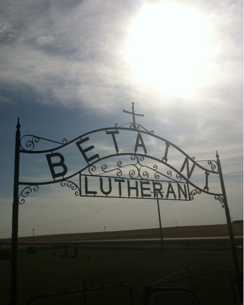
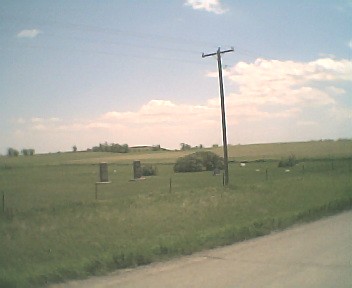
| Description | : | Township 156 - Range 95 - Section 7 of Dry Fork Township 34 miles East on Hwy #1804, 5 miles North on Cnty #21, on East corner of section road. The cemetery was near the church (which no longer stands) and is well maintained and burials are still being made there today. |
frequently asked questions (FAQ):
-
Where is Betaini Lutheran Cemetery?
Betaini Lutheran Cemetery is located at Tioga, Williams County ,North Dakota ,USA.
-
Betaini Lutheran Cemetery cemetery's updated grave count on graveviews.com?
1 memorials
-
Where are the coordinates of the Betaini Lutheran Cemetery?
Latitude: 48.2691994
Longitude: -102.9558029
Nearby Cemetories:
1. Trinity Lutheran Cemetery
Tioga, Williams County, USA
Coordinate: 48.2980800, -102.9476700
2. Emmanual Lutheran German Cemetery
Ray, Williams County, USA
Coordinate: 48.3278008, -103.0580978
3. Barstad Cemetery
Tioga, Williams County, USA
Coordinate: 48.1746560, -102.9990800
4. Kristiansand Cemetery
White Earth, Mountrail County, USA
Coordinate: 48.2839012, -102.8050003
5. Beaver Creek Cemetery
Tioga, Williams County, USA
Coordinate: 48.1751900, -103.0217650
6. Minton Cemetery
Williams County, USA
Coordinate: 48.3867760, -102.9412060
7. United Cemetery
Tioga, Williams County, USA
Coordinate: 48.3885994, -102.9396973
8. Zion Lutheran Cemetery
Tioga, Williams County, USA
Coordinate: 48.3911018, -102.9411011
9. Hilltop Cemetery
Wheelock, Williams County, USA
Coordinate: 48.2915560, -103.1414530
10. Eastside Cemetery
Tioga, Williams County, USA
Coordinate: 48.3939018, -102.9235992
11. Temple Cemetery
Temple, Williams County, USA
Coordinate: 48.3871994, -103.0475006
12. Bakken Cemetery
Tioga, Williams County, USA
Coordinate: 48.4160995, -102.9216995
13. Saint Francis Catholic Cemetery
White Earth, Mountrail County, USA
Coordinate: 48.3724213, -102.7795181
14. White Earth Cemetery
White Earth, Mountrail County, USA
Coordinate: 48.3718987, -102.7639008
15. Saint Michaels Cemetery
Ray, Williams County, USA
Coordinate: 48.3483009, -103.1781006
16. Soine Family Cemetery
Ray, Williams County, USA
Coordinate: 48.3349990, -103.1952670
17. Sunset Rest Cemetery
Ray, Williams County, USA
Coordinate: 48.3431015, -103.1905975
18. Dunkard Church Cemetery
Wheelock, Williams County, USA
Coordinate: 48.3431620, -103.2371250
19. Wheelock Cemetery
Wheelock, Williams County, USA
Coordinate: 48.2874985, -103.2596970
20. Norman Lutheran Cemetery
White Earth, Mountrail County, USA
Coordinate: 48.4879417, -102.8506165
21. Manitou Cemetery
Mountrail County, USA
Coordinate: 48.3278008, -102.6196976
22. Antelope Cemetery
McKenzie County, USA
Coordinate: 48.0518990, -102.8067017
23. Saint Olaf Cemetery
Temple, Williams County, USA
Coordinate: 48.5069008, -103.0160980
24. Garden Valley Cemetery
Watford City, McKenzie County, USA
Coordinate: 48.0633011, -103.1453018