
| Memorials | : | 5 |
| Location | : | Ray, Williams County, USA |
| Coordinate | : | 48.3278008, -103.0580978 |
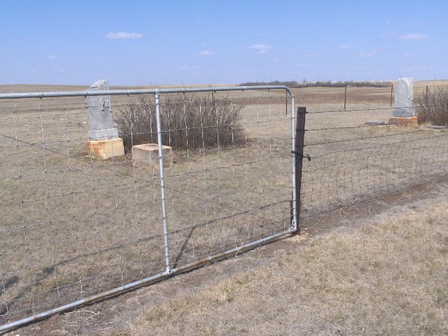
| Description | : | Township 156 - Range 96 - Section 17 of Westbank Township Located 4 miles East of Ray on Hwy #2, 1 mile South past a grove of trees, 1/2 mile East on old section road. This cemetery is located beside the old church (which is outside the fence, is leaning and has since fallen over). It is fenced in with a sturdy gate at the entrance, no sign and well maintained. The church was used on the upstairs floor and the pastor lived in a 3 room parsonage on the main floor. |
frequently asked questions (FAQ):
-
Where is Emmanual Lutheran German Cemetery?
Emmanual Lutheran German Cemetery is located at Ray, Williams County ,North Dakota ,USA.
-
Emmanual Lutheran German Cemetery cemetery's updated grave count on graveviews.com?
5 memorials
-
Where are the coordinates of the Emmanual Lutheran German Cemetery?
Latitude: 48.3278008
Longitude: -103.0580978
Nearby Cemetories:
1. Temple Cemetery
Temple, Williams County, USA
Coordinate: 48.3871994, -103.0475006
2. Hilltop Cemetery
Wheelock, Williams County, USA
Coordinate: 48.2915560, -103.1414530
3. Trinity Lutheran Cemetery
Tioga, Williams County, USA
Coordinate: 48.2980800, -102.9476700
4. Saint Michaels Cemetery
Ray, Williams County, USA
Coordinate: 48.3483009, -103.1781006
5. Sunset Rest Cemetery
Ray, Williams County, USA
Coordinate: 48.3431015, -103.1905975
6. Betaini Lutheran Cemetery
Tioga, Williams County, USA
Coordinate: 48.2691994, -102.9558029
7. Soine Family Cemetery
Ray, Williams County, USA
Coordinate: 48.3349990, -103.1952670
8. Minton Cemetery
Williams County, USA
Coordinate: 48.3867760, -102.9412060
9. United Cemetery
Tioga, Williams County, USA
Coordinate: 48.3885994, -102.9396973
10. Zion Lutheran Cemetery
Tioga, Williams County, USA
Coordinate: 48.3911018, -102.9411011
11. Eastside Cemetery
Tioga, Williams County, USA
Coordinate: 48.3939018, -102.9235992
12. Dunkard Church Cemetery
Wheelock, Williams County, USA
Coordinate: 48.3431620, -103.2371250
13. Bakken Cemetery
Tioga, Williams County, USA
Coordinate: 48.4160995, -102.9216995
14. Wheelock Cemetery
Wheelock, Williams County, USA
Coordinate: 48.2874985, -103.2596970
15. Beaver Creek Cemetery
Tioga, Williams County, USA
Coordinate: 48.1751900, -103.0217650
16. Barstad Cemetery
Tioga, Williams County, USA
Coordinate: 48.1746560, -102.9990800
17. Kristiansand Cemetery
White Earth, Mountrail County, USA
Coordinate: 48.2839012, -102.8050003
18. Saint Olaf Cemetery
Temple, Williams County, USA
Coordinate: 48.5069008, -103.0160980
19. Saint Francis Catholic Cemetery
White Earth, Mountrail County, USA
Coordinate: 48.3724213, -102.7795181
20. Rainbow Valley Lutheran Cemetery
Wildrose, Williams County, USA
Coordinate: 48.4802361, -103.2330551
21. White Earth Cemetery
White Earth, Mountrail County, USA
Coordinate: 48.3718987, -102.7639008
22. Saint Mary Catholic Cemetery
Epping, Williams County, USA
Coordinate: 48.2671380, -103.3453700
23. Epping Cemetery
Epping, Williams County, USA
Coordinate: 48.2602997, -103.3550034
24. Norman Lutheran Cemetery
White Earth, Mountrail County, USA
Coordinate: 48.4879417, -102.8506165