

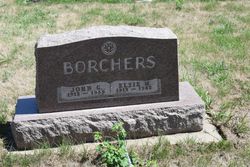
John Gerhard “Jack” Borchers
| Birth | : | 28 Dec 1912 Plymouth County, Iowa, USA |
| Death | : | 11 Dec 1969 Le Mars, Plymouth County, Iowa, USA |
| Burial | : | Corinth Church Cemetery, Darden, Henderson County, USA |
| Coordinate | : | 35.6585850, -88.2381060 |
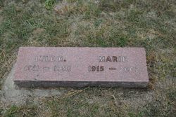
| Description | : | John (Jack) Gerhard Borchers, 56, route 3, Le Mars, and lifelong resident of Plymouth County died Thursday at Floyd Valley hospital after an extended illness. Funeral services were held at St. Peter Lutheran church, Brunsville, Saturday at 2:30 p.m. with Rev. Olaf Rossing officiating. Burial was in St. Peter Lutheran cemetery, Brunsville, under direction of Mauer Funeral Home. He was born December 28, 1912, in Preston township, a son of the late William and Margaret (Johnson) Borchers. He married Elsie Klemme in 1933 in Preston township. She died in 1962 and then in 1964 he married Eleanor DuBois... Read More |
frequently asked questions (FAQ):
-
Where is John Gerhard “Jack” Borchers's memorial?
John Gerhard “Jack” Borchers's memorial is located at: Corinth Church Cemetery, Darden, Henderson County, USA.
-
When did John Gerhard “Jack” Borchers death?
John Gerhard “Jack” Borchers death on 11 Dec 1969 in Le Mars, Plymouth County, Iowa, USA
-
Where are the coordinates of the John Gerhard “Jack” Borchers's memorial?
Latitude: 35.6585850
Longitude: -88.2381060
Family Members:
Parent

Spouse
Siblings
Children
Flowers:


Nearby Cemetories:
1. Corinth Church Cemetery
Darden, Henderson County, USA
Coordinate: 35.6585850, -88.2381060
2. Darden Cemetery
Darden, Henderson County, USA
Coordinate: 35.6388910, -88.2244260
3. Hayes Cemetery
Darden, Henderson County, USA
Coordinate: 35.6702050, -88.2136140
4. Duke Memorial Cemetery
Henderson County, USA
Coordinate: 35.6863590, -88.2364690
5. Union Church Cemetery
Chesterfield, Henderson County, USA
Coordinate: 35.6336500, -88.2573400
6. Derryberry Cemetery
Darden, Henderson County, USA
Coordinate: 35.6898520, -88.2218400
7. Central Grove Church Cemetery
Chesterfield, Henderson County, USA
Coordinate: 35.6705220, -88.2831450
8. Dukes Cemetery
Darden, Henderson County, USA
Coordinate: 35.6435210, -88.1928930
9. Evans Cemetery
Henderson County, USA
Coordinate: 35.6977997, -88.2172012
10. Mount Ararat Cemetery
Darden, Henderson County, USA
Coordinate: 35.6907997, -88.2031021
11. Bible Grove Cemetery
Henderson County, USA
Coordinate: 35.7001620, -88.2704020
12. McCall Cemetery
Lexington, Henderson County, USA
Coordinate: 35.6481018, -88.2981033
13. Keen Cemetery
Parsons, Decatur County, USA
Coordinate: 35.6459090, -88.1715020
14. Moore Cemetery
Darden, Henderson County, USA
Coordinate: 35.7159150, -88.2280760
15. Wallace Cemetery
Henderson County, USA
Coordinate: 35.6514015, -88.3094025
16. Myracle Family Cemetery
Parsons, Decatur County, USA
Coordinate: 35.6234610, -88.1776630
17. Stephen Roberson Gravesite
Darden, Henderson County, USA
Coordinate: 35.7097750, -88.1919380
18. Crowell Chapel Cemetery
Henderson County, USA
Coordinate: 35.5952860, -88.2318640
19. Presley Cemetery
Darden, Henderson County, USA
Coordinate: 35.5928120, -88.2259270
20. Jowers Cemetery
Lexington, Henderson County, USA
Coordinate: 35.6892780, -88.3114600
21. Judson Cemetery
Middleburg, Henderson County, USA
Coordinate: 35.5947350, -88.2641960
22. Lewis-Altom Cemetery
Wildersville, Henderson County, USA
Coordinate: 35.7240750, -88.2576840
23. Oak Grove Methodist Church Cemetery
Middleburg, Henderson County, USA
Coordinate: 35.5922290, -88.2527470
24. Newsom Family Cemetery
Henderson County, USA
Coordinate: 35.5948410, -88.2104270