
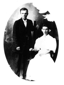
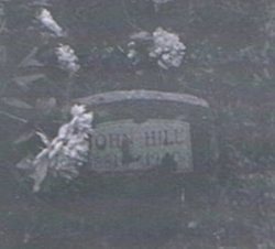
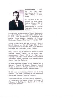

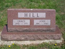
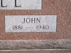
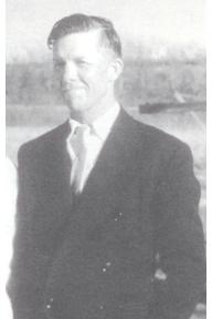
John Hill
| Birth | : | 13 Jun 1881 Dragoon Township, Osage County, Kansas, USA |
| Death | : | 31 Jan 1940 Dragoon Township, Osage County, Kansas, USA |
| Burial | : | Fort Jackson National Cemetery, Columbia, Richland County, USA |
| Coordinate | : | 34.0900560, -80.8490750 |
| Plot | : | Sect 238, Plot 9 |
| Description | : | John was born in Dragoon township (just 200 yards east of the present-day intersectin of 181st & Crawford Rd - West 1/2, NW Qtr, Sect 24, Dragoon Township 15, Range 13), which is about 5 miles West/Southwest of Burlingame, Kansas He moved from Kansas to Woodnorth, Manitoba in the fall of 1895 with his family, then returned to Dragoon Township in 1907 (and settled just a 1/2 miles southwest of his original birthplace on the Thomas Masters place). |
frequently asked questions (FAQ):
-
Where is John Hill's memorial?
John Hill's memorial is located at: Fort Jackson National Cemetery, Columbia, Richland County, USA.
-
When did John Hill death?
John Hill death on 31 Jan 1940 in Dragoon Township, Osage County, Kansas, USA
-
Where are the coordinates of the John Hill's memorial?
Latitude: 34.0900560
Longitude: -80.8490750
Family Members:
Parent

Spouse

Siblings
Children
Flowers:


Nearby Cemetories:
1. Fort Jackson National Cemetery
Columbia, Richland County, USA
Coordinate: 34.0900560, -80.8490750
2. Ford Family Graves
Columbia, Richland County, USA
Coordinate: 34.0919930, -80.8771630
3. Spears Creek Baptist Church Cemetery
Pontiac, Richland County, USA
Coordinate: 34.1042140, -80.8249520
4. Salem Methodist Church Cemetery
Richland County, USA
Coordinate: 34.0886002, -80.8116989
5. Spring Valley Presbyterian Memorial Gardens
Spring Valley, Richland County, USA
Coordinate: 34.1124482, -80.8804385
6. Enon Cemetery
Columbia, Richland County, USA
Coordinate: 34.0661011, -80.8788986
7. Royal Pines Independent Holiness Church Cemetery
Pontiac, Richland County, USA
Coordinate: 34.1211310, -80.8694600
8. Richland County Cemetery
Pontiac, Richland County, USA
Coordinate: 34.1223570, -80.8677770
9. Northeast Presbyterian Church Cemetery
Columbia, Richland County, USA
Coordinate: 34.0961690, -80.8919480
10. Saint Davids Episcopal Church Cemetery
Columbia, Richland County, USA
Coordinate: 34.0961790, -80.8929210
11. Saint John Neumann Catholic Church Cemetery
Columbia, Richland County, USA
Coordinate: 34.1033800, -80.8967150
12. Midway Methodist Church Cemetery
Columbia, Richland County, USA
Coordinate: 34.0756080, -80.8983890
13. Spring Valley Pentecostal Holiness Church Cemetery
Pontiac, Richland County, USA
Coordinate: 34.1100630, -80.8961530
14. Mount Pleasant Baptist Church Cemetery
Richland County, USA
Coordinate: 34.0514000, -80.8178000
15. Oak Grove Baptist Church
Elgin, Kershaw County, USA
Coordinate: 34.1368770, -80.8513150
16. Macedonia Cemetery
Richland County, USA
Coordinate: 34.0483017, -80.8846970
17. Corley Chapel Cemetery
Columbia, Richland County, USA
Coordinate: 34.0749454, -80.9081729
18. Alpine Baptist Church Cemetery
Columbia, Richland County, USA
Coordinate: 34.0650500, -80.9053840
19. Old Macedonia Cemetery
Columbia, Richland County, USA
Coordinate: 34.0664260, -80.9073220
20. Sandy Run Protestant Methodist Church Cemetery
Pontiac, Richland County, USA
Coordinate: 34.1475990, -80.8548260
21. Greenhaven Memorial Gardens
Richland County, USA
Coordinate: 34.1479590, -80.8245330
22. Jacobs Mission A.M.E. Church Cemetery
Richland County, USA
Coordinate: 34.1548030, -80.8506160
23. Enon Southern Methodist Church Cemetery
Columbia, Richland County, USA
Coordinate: 34.0569680, -80.9173300
24. Northeast Wesleyan Church Cemetery
Columbia, Richland County, USA
Coordinate: 34.1171350, -80.9236410