
John Hisel
| Birth | : | 2 Feb 1840 Belgium |
| Death | : | 19 Mar 1899 Jefferson County, Iowa, USA |
| Burial | : | Shady Grove Union Cemetery, Brandonville, Preston County, USA |
| Coordinate | : | 39.6739006, -79.5960999 |
| Plot | : | Old.P.264 |
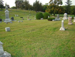
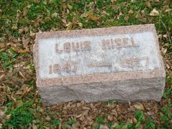
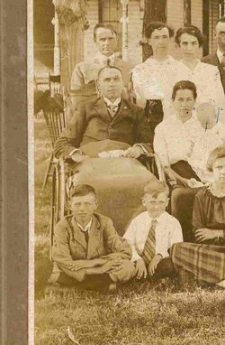
| Description | : | Son of Anthony (sp. varies) Heisel and Mary Susanne Jubert Heisel. Adopted the Hisel spelling of the surname. Married Susanna Welch on September 12, 1870. Children: Percy Chase, Alice Maud, Edna, Clara May, John J. and Walter Welch Hisel. Note: believed to have been originally buried elsewhere in the cemetery, then he was taken to the Fairfield Abbey mausoleum. In 1962 the Fairfield Abbey was pending closure due to structural problems; this Hisel family was re-interred in Old.P. 264 in 1962. Note: photo shown on this memorial is of the approximate unmarked graves of this Hisel family. Roughly in the center of the... Read More |
frequently asked questions (FAQ):
-
Where is John Hisel's memorial?
John Hisel's memorial is located at: Shady Grove Union Cemetery, Brandonville, Preston County, USA.
-
When did John Hisel death?
John Hisel death on 19 Mar 1899 in Jefferson County, Iowa, USA
-
Where are the coordinates of the John Hisel's memorial?
Latitude: 39.6739006
Longitude: -79.5960999
Family Members:
Parent


Spouse

Siblings

Children


Flowers:


Nearby Cemetories:
1. Shady Grove Union Cemetery
Brandonville, Preston County, USA
Coordinate: 39.6739006, -79.5960999
2. Brandonville Cemetery
Brandonville, Preston County, USA
Coordinate: 39.6667400, -79.6193100
3. Frankhouser Cemetery
Brandonville, Preston County, USA
Coordinate: 39.6545000, -79.5753000
4. Salem-Thomas Cemetery
Clifton Mills, Preston County, USA
Coordinate: 39.6972970, -79.5787720
5. Reverend John Boger Cemetery
Brandonville, Preston County, USA
Coordinate: 39.6623310, -79.5577120
6. Pleasant Grove Cemetery
Brandonville, Preston County, USA
Coordinate: 39.6941986, -79.5614014
7. Glover Cemetery
Glade Farms, Preston County, USA
Coordinate: 39.6943390, -79.5606420
8. Bruceton Mills Cemetery
Bruceton Mills, Preston County, USA
Coordinate: 39.6666100, -79.6402150
9. Sugar Valley Cemetery
Bruceton Mills, Preston County, USA
Coordinate: 39.6665993, -79.6404037
10. Mitchell Cemetery
Glade Farms, Preston County, USA
Coordinate: 39.6925470, -79.5294020
11. Jeffreys Cemetery
Hazelton, Preston County, USA
Coordinate: 39.6446160, -79.5351210
12. Ringer Cemetery
Bruceton Mills, Preston County, USA
Coordinate: 39.6175680, -79.6206020
13. Saint Peters Lutheran Cemetery
Clifton Mills, Preston County, USA
Coordinate: 39.7035860, -79.6691010
14. Cuppett - Teets Cemetery
Glade Farms, Preston County, USA
Coordinate: 39.7101700, -79.5225000
15. Danks Cemetery
Bruceton Mills, Preston County, USA
Coordinate: 39.6256110, -79.5290560
16. Centenary Cemetery
Cuzzart, Preston County, USA
Coordinate: 39.6000920, -79.6036560
17. Carroll Family Cemetery
Fayette County, USA
Coordinate: 39.7398300, -79.5435100
18. Maust Cemetery
Clifton Mills, Preston County, USA
Coordinate: 39.7202600, -79.6769710
19. Parnell Cemetery
Cuzzart, Preston County, USA
Coordinate: 39.5991900, -79.5687000
20. Webb Chapel Cemetery
Hazelton, Preston County, USA
Coordinate: 39.6648210, -79.4915600
21. Mountain Grove Church of the Brethren Cemetery
Laurel Run, Preston County, USA
Coordinate: 39.7003564, -79.6989387
22. Everly Cemetery
Laurel Run, Preston County, USA
Coordinate: 39.6725722, -79.7048876
23. Savage Cemetery
Hazelton, Preston County, USA
Coordinate: 39.6323470, -79.5003360
24. VanSickle Cemetery
Hazelton, Preston County, USA
Coordinate: 39.6800840, -79.4850690