
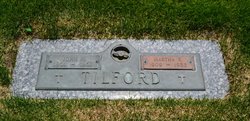
John Hugh Tilford Jr.
| Birth | : | 27 May 1901 Lincoln County, Nebraska, USA |
| Death | : | 13 Feb 1963 North Platte, Lincoln County, Nebraska, USA |
| Burial | : | Holy Rood Churchyard, Shilton, West Oxfordshire District, England |
| Coordinate | : | 51.7726519, -1.6142058 |
frequently asked questions (FAQ):
-
Where is John Hugh Tilford Jr.'s memorial?
John Hugh Tilford Jr.'s memorial is located at: Holy Rood Churchyard, Shilton, West Oxfordshire District, England.
-
When did John Hugh Tilford Jr. death?
John Hugh Tilford Jr. death on 13 Feb 1963 in North Platte, Lincoln County, Nebraska, USA
-
Where are the coordinates of the John Hugh Tilford Jr.'s memorial?
Latitude: 51.7726519
Longitude: -1.6142058
Family Members:
Parent
Spouse

Siblings

Flowers:


Nearby Cemetories:
1. Holy Rood Churchyard
Shilton, West Oxfordshire District, England
Coordinate: 51.7726519, -1.6142058
2. Holy Trinity Church
Witney, West Oxfordshire District, England
Coordinate: 51.7726500, -1.6142050
3. St. Britius Churchyard
Brize Norton, West Oxfordshire District, England
Coordinate: 51.7662000, -1.5667000
4. St. Britius Churchyard Extension
Brize Norton, West Oxfordshire District, England
Coordinate: 51.7660800, -1.5662600
5. St Nicholas Parish Church
Asthall, West Oxfordshire District, England
Coordinate: 51.8003600, -1.5850500
6. St. Peter's Churchyard
Alvescot, West Oxfordshire District, England
Coordinate: 51.7392910, -1.6046704
7. St Georges Churchyard
Kencot, West Oxfordshire District, England
Coordinate: 51.7407160, -1.6330900
8. St Oswald's Churchyard
Widford, West Oxfordshire District, England
Coordinate: 51.8067780, -1.6047160
9. Baptist Burial Ground
Burford, West Oxfordshire District, England
Coordinate: 51.8070150, -1.6338030
10. St Mary Churchyard
Swinbrook, West Oxfordshire District, England
Coordinate: 51.8072090, -1.5954540
11. St. John the Baptist Churchyard
Burford, West Oxfordshire District, England
Coordinate: 51.8096490, -1.6341730
12. Saint Mary's Churchyard
Black Bourton, West Oxfordshire District, England
Coordinate: 51.7360520, -1.5864600
13. Burford Cemetery
Burford, West Oxfordshire District, England
Coordinate: 51.8084000, -1.6489600
14. St. Mary's Churchyard
Westwell, West Oxfordshire District, England
Coordinate: 51.7886840, -1.6779678
15. St James The Great Churchyard
Fulbrook, West Oxfordshire District, England
Coordinate: 51.8153500, -1.6265430
16. St Peter's Churchyard
Filkins, West Oxfordshire District, England
Coordinate: 51.7358700, -1.6578250
17. Saint Matthew's Churchyard
Langford, West Oxfordshire District, England
Coordinate: 51.7209390, -1.6405280
18. St. Stephen's Churchyard
Clanfield, West Oxfordshire District, England
Coordinate: 51.7174060, -1.5911740
19. St. John The Evangelist Churchyard
Taynton, West Oxfordshire District, England
Coordinate: 51.8216040, -1.6621950
20. Saint Kenelm's Churchyard
Minster Lovell, West Oxfordshire District, England
Coordinate: 51.8000620, -1.5314550
21. St John The Baptist
Curbridge, West Oxfordshire District, England
Coordinate: 51.7764570, -1.5203140
22. Bampton Cemetery
Bampton, West Oxfordshire District, England
Coordinate: 51.7296400, -1.5490200
23. St. Mary the Virgin Churchyard
Bampton, West Oxfordshire District, England
Coordinate: 51.7278250, -1.5487270
24. St. Andrew's Churchyard
Eastleach, Cotswold District, England
Coordinate: 51.7465120, -1.7087670