
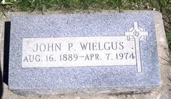
John P. Wielgus
| Birth | : | 16 Aug 1889 Poland |
| Death | : | 7 Apr 1974 USA |
| Burial | : | Lancaster Priory, Lancaster, City of Lancaster, England |
| Coordinate | : | 54.0507360, -2.8057850 |
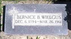
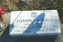
| Description | : | Son of Thomas & Mary (Tutaz) Wielgus. Married to Bernice P. Brezenski. One of his sons died in WW II. Memorial #10277099. From the web page: http://www.usgennet.org/usa/ne/topic/resources/OLLibrary/Platte/pages/heros/hpcn0185.htm Staff Sergeant John J. Wielgus was born at Fullerton, Nebraska, in Nance County, on October 27, 1914, and was killed in action in France on July 14, 1944. He was the son of Mr. and Mrs. John Wielgus of Columbus, Nebraska. His brothers and sisters were: Stephen Wielgus of Columbus, who was in the United States Navy and served as an electrician's mate, third class, during World War II; Louis Wielgus, serving with the United States Army Air Corps... Read More |
frequently asked questions (FAQ):
-
Where is John P. Wielgus's memorial?
John P. Wielgus's memorial is located at: Lancaster Priory, Lancaster, City of Lancaster, England.
-
When did John P. Wielgus death?
John P. Wielgus death on 7 Apr 1974 in USA
-
Where are the coordinates of the John P. Wielgus's memorial?
Latitude: 54.0507360
Longitude: -2.8057850
Family Members:
Spouse
Children
Flowers:


Nearby Cemetories:
1. Lancaster Priory
Lancaster, City of Lancaster, England
Coordinate: 54.0507360, -2.8057850
2. Lancaster Castle Cemetery
Lancaster, City of Lancaster, England
Coordinate: 54.0494330, -2.8047890
3. Friends Meeting House Burial Ground
Lancaster, City of Lancaster, England
Coordinate: 54.0482500, -2.8058025
4. St. John the Evangelist Churchyard
Lancaster, City of Lancaster, England
Coordinate: 54.0504000, -2.7990000
5. Mount Street Congregational Chapel
Lancaster, City of Lancaster, England
Coordinate: 54.0468260, -2.8027430
6. St. Nicholas Street Chapel Churchyard
Lancaster, City of Lancaster, England
Coordinate: 54.0486900, -2.7987900
7. Saint Luke's Parish Churchyard
Skerton, City of Lancaster, England
Coordinate: 54.0564700, -2.7982600
8. Cathedral Cemetery of Lancaster
Lancaster, City of Lancaster, England
Coordinate: 54.0471170, -2.7942920
9. Skerton Cemetery
Lancaster, City of Lancaster, England
Coordinate: 54.0651430, -2.7951140
10. Lancaster and Morecambe Crematorium
Lancaster, City of Lancaster, England
Coordinate: 54.0650890, -2.8198420
11. Lancaster Cemetery
Lancaster, City of Lancaster, England
Coordinate: 54.0504210, -2.7768760
12. Scotforth Cemetery
Scotforth, City of Lancaster, England
Coordinate: 54.0282250, -2.8007170
13. Torrisholme Cemetery
Morecambe, City of Lancaster, England
Coordinate: 54.0638980, -2.8409800
14. St Wilfrid's Churchyard
Halton, City of Lancaster, England
Coordinate: 54.0759400, -2.7672600
15. Slyne Cemetery
Slyne, City of Lancaster, England
Coordinate: 54.0868185, -2.7969423
16. Holy Trinity Church Poulton-le-Sands
Morecambe, City of Lancaster, England
Coordinate: 54.0744769, -2.8569331
17. Morecambe Cemetery
Morecambe, City of Lancaster, England
Coordinate: 54.0759090, -2.8572610
18. St Peter's Churchyard
Quernmore, City of Lancaster, England
Coordinate: 54.0367200, -2.7375400
19. Hale Carr Lane Cemetery
Morecambe, City of Lancaster, England
Coordinate: 54.0520500, -2.8833940
20. Quernmore Methodist Churchyard
Quernmore, City of Lancaster, England
Coordinate: 54.0259440, -2.7361400
21. St. Helen's Churchyard
Overton, City of Lancaster, England
Coordinate: 54.0111620, -2.8552950
22. Christ Church United Reform Church
Bolton-le-Sands, City of Lancaster, England
Coordinate: 54.1015860, -2.7929000
23. Holy Trinity Churchyard
Bolton-le-Sands, City of Lancaster, England
Coordinate: 54.1027700, -2.7911700
24. St John’s Church Graveyard
Ellel, City of Lancaster, England
Coordinate: 53.9990010, -2.7846660