
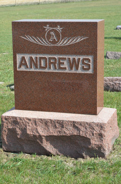

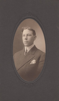
John Paul Andrews
| Birth | : | 21 Jan 1861 Buffalo, Erie County, New York, USA |
| Death | : | 31 Aug 1920 Stratford, Hamilton County, Iowa, USA |
| Burial | : | South Marion Cemetery, Stratford, Hamilton County, USA |
| Coordinate | : | 42.2327995, -93.8735962 |
| Description | : | Stratford Courier August 26, 1920 STRICKEN WITH PARALYSIS John Andrews, a prominent farmer living southeast of Stratford, was stricken with paralysis Tuesday night. He had gone to the barn to milk and was later found lying there unable to move or talk. His condition is considered serious. He had been in poor health for some time and expected to start for the west yesterday morning for the benefit of his health. The many friends of the family trust his trouble will be only temporary and that he will soon be able to be about again. ******* Stratford Courier September 9, 1920 OBITUARY Andrews John Paul Andrews was born Jan.... Read More |
frequently asked questions (FAQ):
-
Where is John Paul Andrews's memorial?
John Paul Andrews's memorial is located at: South Marion Cemetery, Stratford, Hamilton County, USA.
-
When did John Paul Andrews death?
John Paul Andrews death on 31 Aug 1920 in Stratford, Hamilton County, Iowa, USA
-
Where are the coordinates of the John Paul Andrews's memorial?
Latitude: 42.2327995
Longitude: -93.8735962
Family Members:
Parent

Spouse

Siblings

Children

Flowers:


Nearby Cemetories:
1. South Marion Cemetery
Stratford, Hamilton County, USA
Coordinate: 42.2327995, -93.8735962
2. Oakwood Cemetery
Stratford, Hamilton County, USA
Coordinate: 42.2942009, -93.9182968
3. Mineral Ridge Cemetery
Ridgeport, Boone County, USA
Coordinate: 42.1749992, -93.9266968
4. Hooks Point Cemetery
Hamilton County, USA
Coordinate: 42.2944530, -93.9199090
5. Hardin Township Cemetery
Hardin Township, Webster County, USA
Coordinate: 42.2411003, -93.9708023
6. Saint Paul Lutheran Cemetery
Boone, Boone County, USA
Coordinate: 42.1700000, -93.8070000
7. Boone County Poor Farm Cemetery
Boone County, USA
Coordinate: 42.1591100, -93.9159000
8. White Cemetery
Boone County, USA
Coordinate: 42.1777992, -93.9636002
9. Lake Center Cemetery
Stanhope, Hamilton County, USA
Coordinate: 42.2482986, -93.7568970
10. Leininger Cemetery
Boone County, USA
Coordinate: 42.1492004, -93.8356018
11. Lawn Hill Cemetery
Stanhope, Hamilton County, USA
Coordinate: 42.2677994, -93.7611008
12. Nesse Cemetery
Hamilton County, USA
Coordinate: 42.3250008, -93.8933029
13. Neese Cemetery
Homer, Hamilton County, USA
Coordinate: 42.3250000, -93.8935000
14. Linn Cemetery
Pilot Mound, Boone County, USA
Coordinate: 42.2045330, -93.9970230
15. Vegors Cemetery
Webster County, USA
Coordinate: 42.3177986, -93.9421997
16. Mackey Cemetery
Boone County, USA
Coordinate: 42.1675000, -93.7565000
17. Runyan Cemetery
Pilot Mound, Boone County, USA
Coordinate: 42.1749992, -94.0015030
18. Saint Pauls Church Cemetery
Jewell, Hamilton County, USA
Coordinate: 42.2490100, -93.7173400
19. Schlicht Cemetery
Fraser, Boone County, USA
Coordinate: 42.1444200, -93.9780100
20. Bass Cemetery
Dayton, Webster County, USA
Coordinate: 42.2966995, -94.0149994
21. Saratoga Cemetery
Stanhope, Hamilton County, USA
Coordinate: 42.3539009, -93.8167038
22. Pilot Mound Cemetery
Pilot Mound, Boone County, USA
Coordinate: 42.1636200, -94.0282600
23. Ellsworth Clear Lake Cemetery
Randall, Hamilton County, USA
Coordinate: 42.2268930, -93.6926200
24. Bass Point Cemetery
Boone, Boone County, USA
Coordinate: 42.0992012, -93.8957977