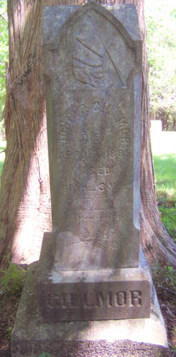
John Pratt Gillmor
| Birth | : | 29 Jan 1844 Washington County, Ohio, USA |
| Death | : | 19 Apr 1885 Nemaha County, Kansas, USA |
| Burial | : | Pleasant Valley Cemetery, Pawnee County, USA |
| Coordinate | : | 40.0299988, -96.1554794 |
| Plot | : | Lot 18 Grave 2 1/2 |
| Description | : | Married Rosina M. Howe on October 3, 1864 in Kankakee Co., Illinois. Father to Emery, Dora, Delinda, George, Charles, Edward and John Peter Gillmor. Private, Co. A., 59th Illinois Infantry. |
frequently asked questions (FAQ):
-
Where is John Pratt Gillmor's memorial?
John Pratt Gillmor's memorial is located at: Pleasant Valley Cemetery, Pawnee County, USA.
-
When did John Pratt Gillmor death?
John Pratt Gillmor death on 19 Apr 1885 in Nemaha County, Kansas, USA
-
Where are the coordinates of the John Pratt Gillmor's memorial?
Latitude: 40.0299988
Longitude: -96.1554794
Family Members:
Flowers:
Nearby Cemetories:
1. Pleasant Valley Cemetery
Pawnee County, USA
Coordinate: 40.0299988, -96.1554794
2. Pleasant Ridge Cemetery
Du Bois, Pawnee County, USA
Coordinate: 40.0156000, -96.1494000
3. Evergreen Cemetery
Pawnee County, USA
Coordinate: 40.0485992, -96.1417007
4. Prairie Star Pioneer Cemetery
Du Bois, Pawnee County, USA
Coordinate: 40.0293000, -96.1041000
5. Saint Peters Evangelican Cemetery
Du Bois, Pawnee County, USA
Coordinate: 40.0010000, -96.1095000
6. McCaffrey Cemetery
Nemaha County, USA
Coordinate: 39.9827100, -96.1474500
7. Johnson Creek Cemetery
Pawnee City, Pawnee County, USA
Coordinate: 40.0270000, -96.2465000
8. Brewer Cemetery
Baileyville, Nemaha County, USA
Coordinate: 39.9556900, -96.1736500
9. Pawnee City Cemetery
Pawnee City, Pawnee County, USA
Coordinate: 40.1109009, -96.1608810
10. DuBois Cemetery
Du Bois, Pawnee County, USA
Coordinate: 40.0231018, -96.0488968
11. Madden Cemetery
Axtell, Marshall County, USA
Coordinate: 39.9866800, -96.2490300
12. Friedens United Church of Christ Cemetery
Bern, Nemaha County, USA
Coordinate: 39.9929008, -96.0529480
13. Scotch Valley Cemetery
Nemaha County, USA
Coordinate: 39.9578018, -96.0699997
14. Cincinnati Cemetery
Du Bois, Pawnee County, USA
Coordinate: 40.0042000, -96.0274963
15. Coal City Cemetery
Seneca, Nemaha County, USA
Coordinate: 39.9498500, -96.0689600
16. West Branch Cemetery
Pawnee County, USA
Coordinate: 40.0787940, -96.2797160
17. Saint Bridget Cemetery
Axtell, Marshall County, USA
Coordinate: 39.9572000, -96.2578000
18. German Lutheran Cemetery
Bern, Nemaha County, USA
Coordinate: 39.9794500, -96.0234300
19. East Amish Cemetery
Table Rock, Pawnee County, USA
Coordinate: 40.1310000, -96.0854000
20. Athens Cemetery
Richardson County, USA
Coordinate: 40.0449982, -95.9852982
21. Ash Point Cemetery
Baileyville, Nemaha County, USA
Coordinate: 39.8962380, -96.2051080
22. Saint John Lutheran Cemetery
Bern, Nemaha County, USA
Coordinate: 39.9538900, -95.9977700
23. Shockleys Fairland Cemetery
Marshall County, USA
Coordinate: 39.9284500, -96.2866500
24. Holy Family Cemetery
Summerfield, Marshall County, USA
Coordinate: 39.9994011, -96.3414001


