
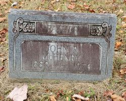
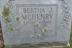
John Randolph McHenry
| Birth | : | 16 Dec 1889 West Virginia, USA |
| Death | : | 15 Feb 1976 Weston, Lewis County, West Virginia, USA |
| Burial | : | Messenger Cemetery, Gilmer County, USA |
| Coordinate | : | 38.9714012, -80.7572021 |
| Description | : | Parents:Samuel and Frances Messenger McHenry |
frequently asked questions (FAQ):
-
Where is John Randolph McHenry's memorial?
John Randolph McHenry's memorial is located at: Messenger Cemetery, Gilmer County, USA.
-
When did John Randolph McHenry death?
John Randolph McHenry death on 15 Feb 1976 in Weston, Lewis County, West Virginia, USA
-
Where are the coordinates of the John Randolph McHenry's memorial?
Latitude: 38.9714012
Longitude: -80.7572021
Family Members:
Spouse
Children
Flowers:


Nearby Cemetories:
1. Messenger Cemetery
Gilmer County, USA
Coordinate: 38.9714012, -80.7572021
2. Hiney Hill Cemetery
Linn, Gilmer County, USA
Coordinate: 38.9676950, -80.7405600
3. Snyder Cemetery Stewarts Creek
Glenville, Gilmer County, USA
Coordinate: 38.9577800, -80.7836100
4. Pickerel Cemetery
Baldwin, Gilmer County, USA
Coordinate: 38.9891200, -80.7289800
5. Conrad Cemetery
Sand Fork, Gilmer County, USA
Coordinate: 38.9364014, -80.7296982
6. Keith Cemetery
Gilmer County, USA
Coordinate: 38.9561005, -80.6986008
7. McHenry Cemetery #1
Sand Fork, Gilmer County, USA
Coordinate: 38.9353310, -80.7162630
8. Farnsworth Cemetery
Linn, Gilmer County, USA
Coordinate: 39.0177994, -80.7378006
9. Otterbein Cemetery
Glenville, Gilmer County, USA
Coordinate: 38.9298550, -80.7916820
10. McHenry Cemetery
Gilmer County, USA
Coordinate: 38.9341870, -80.7130200
11. Dyer Cemetery
Gilmer County, USA
Coordinate: 38.9319000, -80.7110977
12. Varner Cemetery
Sand Fork, Gilmer County, USA
Coordinate: 38.9254709, -80.7212012
13. Leading Creek Baptist Church Cemetery
Alice, Gilmer County, USA
Coordinate: 38.9969000, -80.8183700
14. Hays Cemetery
Truebada, Gilmer County, USA
Coordinate: 38.9294400, -80.8026800
15. Sand Fork Cemetery
Gilmer County, USA
Coordinate: 38.9158890, -80.7480520
16. Troy IOOF Community Cemetery
Troy, Gilmer County, USA
Coordinate: 39.0281170, -80.7679560
17. Rogers Cemetery
Gilmer County, USA
Coordinate: 38.9406013, -80.6936035
18. Rock Grove Cemetery
Latonia, Gilmer County, USA
Coordinate: 39.0125008, -80.7018967
19. Killingsworth Cemetery
Sand Fork, Gilmer County, USA
Coordinate: 38.9169640, -80.7249834
20. Schoonover-Dawson Cemetery
Donlan, Gilmer County, USA
Coordinate: 38.9461770, -80.6854790
21. Old Field Fork Cemetery
Lewis County, USA
Coordinate: 38.9827995, -80.6710968
22. Old Glenville Cemetery
Glenville, Gilmer County, USA
Coordinate: 38.9355000, -80.8322000
23. Boilon Cemetery
Gilmer County, USA
Coordinate: 38.9519005, -80.6718979
24. Weese Family Cemeter
Gilmer County, USA
Coordinate: 38.9208120, -80.8259930