
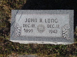
John Rawson Long
| Birth | : | 18 Dec 1899 Loup City, Sherman County, Nebraska, USA |
| Death | : | 17 Dec 1942 Loup City, Sherman County, Nebraska, USA |
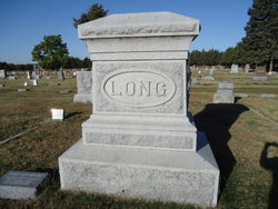
| Burial | : | Evergreen Cemetery, Loup City, Sherman County, USA |
| Coordinate | : | 41.2997017, -98.9852982 |
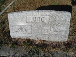
| Description | : | Funeral Services Held Saturday For John R. Long Heart Attack Suffered Last Wednesday Proves Fatal; Rites Saturday. A heart attack suffered early last Wednesday morning proved fatal to John R. Long, one of Loup City's prominent business men and public leaders. Death occurred just before noon on Thursday. Funeral services were held in the Presbyterian church in charge of Rev. W. P. Thompson and burial was in Evergreen cemetery. Pall bearers were: Milo Dailey, A. R. Outhouse, A. L. Brown, E. W. Moehnert, Glen Fletcher and Arnold Lorentz. John Rawson Long, son of John W. and Zella Rawson Long,... Read More |
frequently asked questions (FAQ):
-
Where is John Rawson Long's memorial?
John Rawson Long's memorial is located at: Evergreen Cemetery, Loup City, Sherman County, USA.
-
When did John Rawson Long death?
John Rawson Long death on 17 Dec 1942 in Loup City, Sherman County, Nebraska, USA
-
Where are the coordinates of the John Rawson Long's memorial?
Latitude: 41.2997017
Longitude: -98.9852982
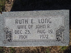
Family Members:
Parent

Spouse
Siblings
Children
Flowers:


Nearby Cemetories:
1. Evergreen Cemetery
Loup City, Sherman County, USA
Coordinate: 41.2997017, -98.9852982
2. Saint Josaphats Cemetery
Loup City, Sherman County, USA
Coordinate: 41.3022003, -98.9847031
3. Sunny Slope Cemetery
Loup City, Sherman County, USA
Coordinate: 41.2906000, -99.0267000
4. Cleoria Cemetery
Loup City, Sherman County, USA
Coordinate: 41.2779000, -99.0893500
5. Balsora Cemetery
Sherman County, USA
Coordinate: 41.3782997, -99.0975037
6. Austin Cemetery
Rockville, Sherman County, USA
Coordinate: 41.1880989, -98.8981018
7. Verdurette Cemetery
Sherman County, USA
Coordinate: 41.1697006, -98.9757996
8. Davis Creek Cemetery
Valley County, USA
Coordinate: 41.4219017, -98.9052963
9. Saint Francis Cemetery
Ashton, Sherman County, USA
Coordinate: 41.2438000, -98.7994000
10. Lone Elm Cemetery
Loup City, Sherman County, USA
Coordinate: 41.2921982, -99.1864014
11. Immanuel Lutheran Cemetery
Ashton, Sherman County, USA
Coordinate: 41.2140000, -98.8142000
12. Gray Cemetery
Sherman County, USA
Coordinate: 41.2099991, -99.1567001
13. Arcadia Cemetery
Arcadia, Valley County, USA
Coordinate: 41.4237000, -99.1167000
14. Pleasant Hill Friends Cemetery
Valley County, USA
Coordinate: 41.4230800, -98.8377700
15. Dunkard Cemetery
Arcadia, Valley County, USA
Coordinate: 41.4522000, -99.0769000
16. Union Cemetery
Ashton, Sherman County, USA
Coordinate: 41.2214012, -98.7855988
17. Litchfield Cemetery
Litchfield, Sherman County, USA
Coordinate: 41.1543999, -99.1283035
18. Mount Carmel Cemetery
Howard County, USA
Coordinate: 41.2797012, -98.7328033
19. Salem Evangelical Church Cemetery
Ord, Valley County, USA
Coordinate: 41.4902992, -98.9244003
20. Lewis Burial Plat
Litchfield, Sherman County, USA
Coordinate: 41.1383000, -99.1484000
21. Trinity Lutheran Church Cemetery
Hazard, Sherman County, USA
Coordinate: 41.0913000, -99.0052000
22. Lee Park Cemetery
Custer County, USA
Coordinate: 41.4025002, -99.2307968
23. Lee Park Catholic Cemetery
Westerville, Custer County, USA
Coordinate: 41.4091988, -99.2311020
24. Saint Marys Cemetery
Rockville, Sherman County, USA
Coordinate: 41.1202000, -98.8255000