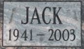
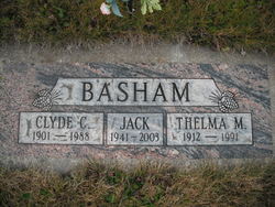
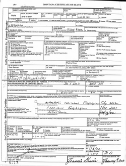
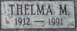
John S “Jack” Basham
| Birth | : | 30 Jul 1941 Sandpoint, Bonner County, Idaho, USA |
| Death | : | 1 Jan 2003 Libby, Lincoln County, Montana, USA |
| Burial | : | Saters Baptist Historical Church Cemetery, Timonium, Baltimore County, USA |
| Coordinate | : | 39.4362920, -76.6870810 |
| Description | : | Jack S. Basham LIBBY - Jack S. Basham, 61, of Libby, died Wednesday, Jan. 1, 2003, at his home from cancer. He was born July 30, 1941, in Sandpoint, Idaho, to Clyde and Thelma Vinion Basham. He moved to Libby in 1946. He married Dixie Griffey on Oct. 9, 1961. Survivors include his wife of 41 years, Dixie Basham of Libby; sons John Basham of Libby and Scott Basham of Phoenix; daughter Becky Halcumb of Gold Beach, Ore.; four grandchildren, Angela Marshall, Kira Basham, Jess Troyer and Eric Vinson; five great-grandchildren; sister Donna Bache of Libby; brother... Read More |
frequently asked questions (FAQ):
-
Where is John S “Jack” Basham's memorial?
John S “Jack” Basham's memorial is located at: Saters Baptist Historical Church Cemetery, Timonium, Baltimore County, USA.
-
When did John S “Jack” Basham death?
John S “Jack” Basham death on 1 Jan 2003 in Libby, Lincoln County, Montana, USA
-
Where are the coordinates of the John S “Jack” Basham's memorial?
Latitude: 39.4362920
Longitude: -76.6870810
Family Members:
Parent
Siblings
Nearby Cemetories:
1. Cockey-Reed Cemetery
Greenspring, Baltimore County, USA
Coordinate: 39.4196400, -76.6671300
2. Mays Chapel Cemetery
Timonium, Baltimore County, USA
Coordinate: 39.4503000, -76.6618300
3. Carrolls-Gills United Methodist Church Cemetery
Lutherville, Baltimore County, USA
Coordinate: 39.4465300, -76.7185900
4. Baltimore County Graveyard #86
Sparks, Baltimore County, USA
Coordinate: 39.4606500, -76.7146800
5. Saint Paul's Evangelical Lutheran Church Cemetery
Shawan, Baltimore County, USA
Coordinate: 39.4716830, -76.7174190
6. Cockey Family Cemetery
Cockeysville, Baltimore County, USA
Coordinate: 39.4635010, -76.6426010
7. Grace Falls Road United Methodist Church Cemetery
Reisterstown, Baltimore County, USA
Coordinate: 39.4771300, -76.7081700
8. Saint Joseph Cemetery
Cockeysville, Baltimore County, USA
Coordinate: 39.4622700, -76.6388100
9. Croxall Family Cemetery
Baltimore County, USA
Coordinate: 39.3968735, -76.7207870
10. Church of the Good Shepherd Memorial Garden
Ruxton, Baltimore County, USA
Coordinate: 39.4024300, -76.6416600
11. Holy Trinity Monastery Cemetery
Pikesville, Baltimore County, USA
Coordinate: 39.3971991, -76.7277734
12. Hook Family Cemetery
Bare Hills, Baltimore County, USA
Coordinate: 39.3886600, -76.6653300
13. Almshouse Cemetery
Cockeysville, Baltimore County, USA
Coordinate: 39.4596200, -76.6278900
14. Nisbet Cemetery
Cockeysville, Baltimore County, USA
Coordinate: 39.4627160, -76.6282660
15. Saint Johns AME Chapel Cemetery
Ruxton, Baltimore County, USA
Coordinate: 39.3944300, -76.6458400
16. Convent of the Mission Helpers of the Sacred Heart
Towson, Baltimore County, USA
Coordinate: 39.4091500, -76.6267530
17. Howard Graveyard at Grayrock
Pikesville, Baltimore County, USA
Coordinate: 39.3954560, -76.7367020
18. Sherwood Episcopal Church Cemetery
Cockeysville, Baltimore County, USA
Coordinate: 39.4828600, -76.6438100
19. Old Gunpowder Friends' Burying Ground
Cockeysville, Baltimore County, USA
Coordinate: 39.4824917, -76.6426611
20. Dulaney Valley Memorial Gardens
Timonium, Baltimore County, USA
Coordinate: 39.4562300, -76.6160700
21. Rosewood State Hospital Cemetery
Owings Mills, Baltimore County, USA
Coordinate: 39.4215500, -76.7619000
22. Saint Thomas Episcopal Church Cemetery
Owings Mills, Baltimore County, USA
Coordinate: 39.4215500, -76.7619000
23. Stone Chapel United Methodist Church Cemetery
Pikesville, Baltimore County, USA
Coordinate: 39.3934000, -76.7407500
24. Price Family Cemetery
Oregon, Baltimore County, USA
Coordinate: 39.4968583, -76.6840278


