
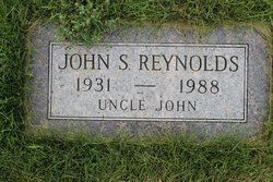
John Stephen Reynolds
| Birth | : | 13 Sep 1931 Havre, Hill County, Montana, USA |
| Death | : | 25 Nov 1988 Great Falls, Cascade County, Montana, USA |
| Burial | : | Highland Cemetery, Havre, Hill County, USA |
| Coordinate | : | 48.5463982, -109.6900024 |
| Plot | : | Space 479 Block 33 |
| Inscription | : | UNCLE JOHN |
| Description | : | 5/5/2022: Suggested edit: Great Falls Tribune (MT), 27 Nov 1988 John S. Reynolds Havre--John S. Reynolds, 57, lifetime farmer, died of cancer Friday at his sister's Great Falls home. His funeral will be at 11 a.m. Tuesday at the Holland and Bonine Funeral Chapel, with burial in Highland Cemetery, Havre. Born in Havre, he took over his father's farm in Kremlin. He graduated from Kremlin High School in 1949. Survivors: sisters, Georgia Birch of Kalispell, Phyllis Curtis of Great Falls, Helen Baggerly of Beaverton, Ore., and Corrine Jones of Missoula; brother, Norman of Kremlin. Contributor: cara (47072115) who added... Read More |
frequently asked questions (FAQ):
-
Where is John Stephen Reynolds's memorial?
John Stephen Reynolds's memorial is located at: Highland Cemetery, Havre, Hill County, USA.
-
When did John Stephen Reynolds death?
John Stephen Reynolds death on 25 Nov 1988 in Great Falls, Cascade County, Montana, USA
-
Where are the coordinates of the John Stephen Reynolds's memorial?
Latitude: 48.5463982
Longitude: -109.6900024
Family Members:
Parent

Siblings
Flowers:


Nearby Cemetories:
1. Highland Cemetery
Havre, Hill County, USA
Coordinate: 48.5463982, -109.6900024
2. Calvary Cemetery
Havre, Hill County, USA
Coordinate: 48.5457000, -109.6883000
3. Mount Hope Cemetery
Havre, Hill County, USA
Coordinate: 48.5540000, -109.7050000
4. Sunset Garden Park
Havre, Hill County, USA
Coordinate: 48.5531006, -109.8019028
5. North Havre Lutheran Church Graveyard (Defunct)
Havre, Hill County, USA
Coordinate: 48.6538903, -109.6815870
6. Grainbelt Cemetery
Hill County, USA
Coordinate: 48.6828003, -109.8657990
7. Andrew S. Lohman Grave Site
Lohman, Blaine County, USA
Coordinate: 48.5903520, -109.4073350
8. East End Colony Cemetery
East End Colony, Hill County, USA
Coordinate: 48.7485000, -109.5474000
9. Hilldale Hutterite Colony Cemetery
Hilldale Colony, Hill County, USA
Coordinate: 48.7997000, -109.7872000
10. Saint Johns Catholic Cemetery
Havre, Hill County, USA
Coordinate: 48.7625008, -109.9638977
11. Saint Gabriel Cemetery
Chinook, Blaine County, USA
Coordinate: 48.6065200, -109.2531200
12. Kuper Memorial Cemetery
Chinook, Blaine County, USA
Coordinate: 48.6083100, -109.2531200
13. Rocky Boy Cemetery
Rocky Boy, Hill County, USA
Coordinate: 48.2572410, -109.7923690
14. Box Elder Cemetery
Box Elder, Hill County, USA
Coordinate: 48.3274000, -110.0095000
15. Rocky Boy Gravel Cemetery
Rocky Boy, Hill County, USA
Coordinate: 48.2427720, -109.7596500
16. Cottonwood Lutheran Church Cemetery
Havre, Hill County, USA
Coordinate: 48.4545000, -110.1748000
17. Bear Paw Battlefield
Chinook, Blaine County, USA
Coordinate: 48.3780070, -109.2121290
18. Hungry Hollow Cemetery
Blaine County, USA
Coordinate: 48.2103004, -109.4677963
19. Milk River Valley Church Graveyard
Hill County, USA
Coordinate: 48.6787180, -110.2261080
20. Hollandville Cemetery
Chinook, Blaine County, USA
Coordinate: 48.6960310, -109.1557200
21. Gildford Hill County Cemetery
Gildford, Hill County, USA
Coordinate: 48.5778008, -110.2957993
22. Prairie Chapel United Brethren Cemetery
Chinook, Blaine County, USA
Coordinate: 48.8860000, -109.3414000
23. Mennonite Brethren Cemetery
Chinook, Blaine County, USA
Coordinate: 48.8012560, -109.1980620
24. Bethel Bruderthaler Mennonite Church Cemetery
Chinook, Blaine County, USA
Coordinate: 48.7552000, -109.1345000