
| Birth | : | 5 Sep 1873 Cedar Falls, Black Hawk County, Iowa, USA |
| Death | : | 11 Dec 1962 Hiawatha, Brown County, Kansas, USA |
| Burial | : | Hiawatha Cemetery, Hiawatha, Brown County, USA |
| Coordinate | : | 39.8601799, -95.5265198 |
| Plot | : | Lot 16 Block 50 |
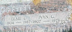
| Description | : | John W. was the son of Christian and Anna Winkler Pfister. He was a farmer. He married Flora May Lewis on February 24, 1898 and they made their home on one of the eighty acres his dad had homesteaded in southwest Brown County. |
frequently asked questions (FAQ):
-
Where is John W Pfister's memorial?
John W Pfister's memorial is located at: Hiawatha Cemetery, Hiawatha, Brown County, USA.
-
When did John W Pfister death?
John W Pfister death on 11 Dec 1962 in Hiawatha, Brown County, Kansas, USA
-
Where are the coordinates of the John W Pfister's memorial?
Latitude: 39.8601799
Longitude: -95.5265198
Family Members:
Parent

Spouse
Siblings
Children

Flowers:


Nearby Cemetories:
1. Hiawatha Cemetery
Hiawatha, Brown County, USA
Coordinate: 39.8601799, -95.5265198
2. Mount Hope Cemetery
Hiawatha, Brown County, USA
Coordinate: 39.8497009, -95.5156021
3. Bemis Cemetery
Hiawatha, Brown County, USA
Coordinate: 39.8194900, -95.5668300
4. Niles Cemetery
Hiawatha, Brown County, USA
Coordinate: 39.8730900, -95.6126300
5. Oakland Cemetery
Padonia, Brown County, USA
Coordinate: 39.9273900, -95.5610900
6. Claytonville Cemetery
Horton, Brown County, USA
Coordinate: 39.7766991, -95.5046997
7. Ununda Cemetery
Robinson, Brown County, USA
Coordinate: 39.8582993, -95.4143982
8. Shelton Cemetery
Hamlin, Brown County, USA
Coordinate: 39.8852997, -95.6393967
9. Hart Cemetery
Reserve, Brown County, USA
Coordinate: 39.9519005, -95.5366974
10. Carson Cemetery
Hamlin, Brown County, USA
Coordinate: 39.8810200, -95.6483100
11. Hamlin Cemetery
Hamlin, Brown County, USA
Coordinate: 39.9206009, -95.6292877
12. Rose Hill Cemetery
Robinson, Brown County, USA
Coordinate: 39.8097000, -95.4139023
13. Pleasant Hill Cemetery
Irving Township, Brown County, USA
Coordinate: 39.9435997, -95.4328232
14. Kenyon Cemetery
Robinson, Brown County, USA
Coordinate: 39.9122000, -95.3964600
15. Pleasant Hill Cemetery
Fairview, Brown County, USA
Coordinate: 39.8411800, -95.6716400
16. Saint Paul Lutheran Cemetery
Fairview, Brown County, USA
Coordinate: 39.8559700, -95.6779700
17. Cornelison Cemetery
Reserve, Brown County, USA
Coordinate: 39.9754105, -95.5485687
18. Madison Cemetery
Robinson, Brown County, USA
Coordinate: 39.7717700, -95.4201700
19. Powhattan Cemetery
Powhattan, Brown County, USA
Coordinate: 39.7681007, -95.6288986
20. Immanuel Lutheran Cemetery
Fairview, Brown County, USA
Coordinate: 39.8559700, -95.6858500
21. Laus Creek Cemetery
Reserve, Brown County, USA
Coordinate: 39.9754105, -95.4699936
22. Pleasant Hill Cemetery
Hamlin, Brown County, USA
Coordinate: 39.9430428, -95.6484299
23. Sun Springs Cemetery
Morrill, Brown County, USA
Coordinate: 39.8993988, -95.6836014
24. Old Fairview Cemetery
Fairview, Brown County, USA
Coordinate: 39.8550491, -95.6948700