
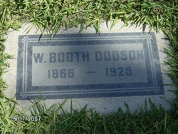
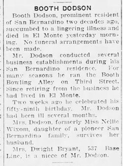
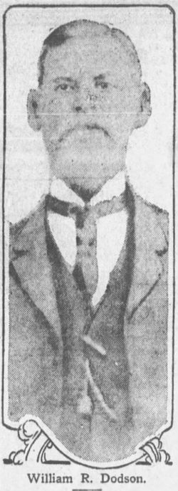
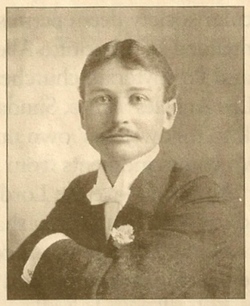
John Wilkes Booth Dodson
| Birth | : | Oct 1866 San Bernardino, San Bernardino County, California, USA |
| Death | : | 7 Nov 1925 El Monte, Los Angeles County, California, USA |
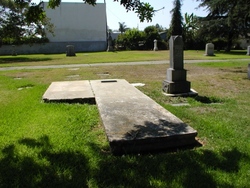
| Burial | : | Dysart Cemetery, Dysart, Tama County, USA |
| Coordinate | : | 42.1608009, -92.3193970 |
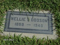
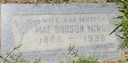
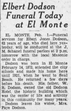
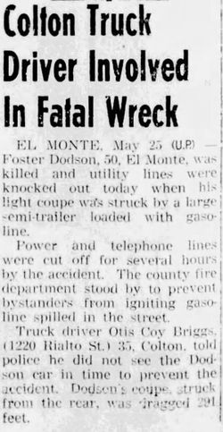
| Description | : | John's parents were: William Riley Dodson, b. Sep. 30, 1839 in Van Buren, Crawford county, Arkansas and d. Mar. 21, 1921 in El Monte, Los Angeles County, CA. & Claramond "Carrie" Jones, b. Feb. 16, 1848 and d. Jun. 29, 1902 in El Monte, Los Angeles County, CA. William & Claramond 'Carrie' Dodson's children were: 1. John Wilkes Booth Dodson, b. Oct. 1866in San Bernardino, San Bernardino county, CA. and d. Nov. 7, 1925 in ElMonte, Los Angeles county, CA. Booth marr. Nellie Isabel Wixom in 1889. 2. Mae Dodson, b. Oct. 1869 in CA. and... Read More |
frequently asked questions (FAQ):
-
Where is John Wilkes Booth Dodson's memorial?
John Wilkes Booth Dodson's memorial is located at: Dysart Cemetery, Dysart, Tama County, USA.
-
When did John Wilkes Booth Dodson death?
John Wilkes Booth Dodson death on 7 Nov 1925 in El Monte, Los Angeles County, California, USA
-
Where are the coordinates of the John Wilkes Booth Dodson's memorial?
Latitude: 42.1608009
Longitude: -92.3193970
Family Members:
Parent
Spouse
Siblings
Children
Flowers:


Nearby Cemetories:
1. Saint Josephs Catholic Cemetery
Benton County, USA
Coordinate: 42.1719017, -92.2981033
2. Rampton Cemetery
Monroe Township, Benton County, USA
Coordinate: 42.1866989, -92.2605972
3. Houghton Cemetery
Benton County, USA
Coordinate: 42.1088982, -92.2794037
4. Gnagy Cemetery
Benton County, USA
Coordinate: 42.1418991, -92.2416992
5. Brown Bruce Township Cemetery
Benton County, USA
Coordinate: 42.2163430, -92.2799680
6. Urmy Cemetery
Benton County, USA
Coordinate: 42.1719017, -92.2281036
7. Lone Pine Cemetery
Tama County, USA
Coordinate: 42.0797005, -92.3082962
8. Oneida Cemetery
Clutier, Tama County, USA
Coordinate: 42.1007996, -92.3966980
9. Hill Cemetery
Tama County, USA
Coordinate: 42.2542000, -92.3075027
10. Clutier Cemetery
Clutier, Tama County, USA
Coordinate: 42.0792007, -92.3858032
11. West Union Cemetery
Traer, Tama County, USA
Coordinate: 42.1817017, -92.4449997
12. Spencer Cemetery
Dysart, Tama County, USA
Coordinate: 42.2592120, -92.3353840
13. Fairview Cemetery
Benton County, USA
Coordinate: 42.2141991, -92.2007980
14. Roadside Cemetery
Clutier, Tama County, USA
Coordinate: 42.0574800, -92.3548800
15. Saint Pauls Catholic Cemetery
Traer, Tama County, USA
Coordinate: 42.1832000, -92.4688000
16. Twogood Cemetery
Benton County, USA
Coordinate: 42.0499992, -92.2799988
17. Geneseo Cemetery
Buckingham, Tama County, USA
Coordinate: 42.2764370, -92.3523950
18. Saint Wenceslaus Cemetery
Clutier, Tama County, USA
Coordinate: 42.0870000, -92.4460000
19. Kirchner Cemetery
Benton County, USA
Coordinate: 42.0727300, -92.2027400
20. Buckingham Cemetery
Traer, Tama County, USA
Coordinate: 42.2069016, -92.4741974
21. Waltham Cemetery
Elberon, Tama County, USA
Coordinate: 42.0355988, -92.3328018
22. Big Grove-Homer Cemetery
Benton County, USA
Coordinate: 42.0867004, -92.1821976
23. Garrison Cemetery
Garrison, Benton County, USA
Coordinate: 42.1369019, -92.1483002
24. Carlisle Grove Cemetery
Garrison, Benton County, USA
Coordinate: 42.1730995, -92.1386032