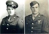
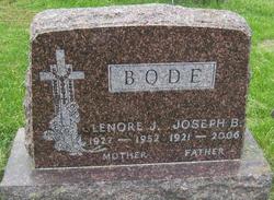
Joseph Benjamin Bode
| Birth | : | 1 Nov 1921 Raeville, Boone County, Nebraska, USA |
| Death | : | 10 Jan 2006 Raeville, Boone County, Nebraska, USA |
| Burial | : | Union Prospect Baptist Church Cemetery, Cologne, King and Queen County, USA |
| Coordinate | : | 37.5139950, -76.6929080 |
| Description | : | Son of Anton F. & Theresa (Pelster) Bode. Married to: 1. Lenore Chavanu on 6-21-1949. 2. Marjorie Kennedy on 3-6-1971. WW II Veteran - US Army Air Corps - Sgt. - July 1942/Feb. 1946 RAEVILLE - Joseph Benjamin Bode, 84, died Tuesday, Jan. 10, 2006, at the Boone County Health Center in Albion. Services will be held at 10:30 a.m. on Saturday at St. Bonaventure Catholic Church in Raeville, with the Rev. Daniel Andrews officiating. Burial is at St. Bonaventure Cemetery, with military rites by American Legion... Read More |
frequently asked questions (FAQ):
-
Where is Joseph Benjamin Bode's memorial?
Joseph Benjamin Bode's memorial is located at: Union Prospect Baptist Church Cemetery, Cologne, King and Queen County, USA.
-
When did Joseph Benjamin Bode death?
Joseph Benjamin Bode death on 10 Jan 2006 in Raeville, Boone County, Nebraska, USA
-
Where are the coordinates of the Joseph Benjamin Bode's memorial?
Latitude: 37.5139950
Longitude: -76.6929080
Family Members:
Flowers:
Nearby Cemetories:
1. Union Prospect Baptist Church Cemetery
Cologne, King and Queen County, USA
Coordinate: 37.5139950, -76.6929080
2. Old Poroporone Cemetery
Cologne, King and Queen County, USA
Coordinate: 37.5228752, -76.6955547
3. Shackelfords Chapel Cemetery
Plain View, King and Queen County, USA
Coordinate: 37.4984000, -76.6741000
4. Beulah Wesleyan Church Cemetery
Cologne, King and Queen County, USA
Coordinate: 37.5471970, -76.6840390
5. First Baptist Church Cemetery
Shacklefords, King and Queen County, USA
Coordinate: 37.5072460, -76.7377920
6. Poroporone Baptist Church Cemetery
Shacklefords, King and Queen County, USA
Coordinate: 37.5514890, -76.7337300
7. New Hope United Methodist Church Cemetery
Gloucester County, USA
Coordinate: 37.5592800, -76.6606130
8. Unnamed Colonial Era Farm Cemetery
Owl Trap, Gloucester County, USA
Coordinate: 37.5239449, -76.6276016
9. Church of God Cemetery
Gloucester, Gloucester County, USA
Coordinate: 37.4736830, -76.6359110
10. New Hope Memorial Baptist Church Cemetery
Shacklefords, King and Queen County, USA
Coordinate: 37.5790900, -76.6766100
11. Morning Glory Baptist Church Cemetery
Gloucester, Gloucester County, USA
Coordinate: 37.4600580, -76.6358830
12. Saint Andrew Cemetery
Gloucester County, USA
Coordinate: 37.5556960, -76.6166210
13. New Mount Zion Baptist Church Cemetery
Gloucester County, USA
Coordinate: 37.5112070, -76.5924850
14. Salem United Methodist Church Cemetery
Gloucester, Gloucester County, USA
Coordinate: 37.5283210, -76.5938500
15. Pamunkey Neck Chapel Cemetery
West Point, King William County, USA
Coordinate: 37.5300962, -76.7955810
16. Marlfield Plantation Cemetery
Marlfield, Gloucester County, USA
Coordinate: 37.4492760, -76.6223860
17. Escobrook Baptist Church Cemetery
Mattaponi, King and Queen County, USA
Coordinate: 37.5947980, -76.7298300
18. Mount Olive Baptist Church Cemetery
Barhamsville, New Kent County, USA
Coordinate: 37.4770830, -76.7909470
19. Petsworth Parish Episcopal Church Cemetery
Gloucester County, USA
Coordinate: 37.4637186, -76.6046384
20. Dixon Cemetery
Mattaponi, King and Queen County, USA
Coordinate: 37.5801570, -76.7693140
21. Oliver Russell Cemetery
Eltham, New Kent County, USA
Coordinate: 37.4993100, -76.8087500
22. Saint Theresas Cemetery
West Point, King William County, USA
Coordinate: 37.5466995, -76.8032990
23. Sunny Slope Cemetery
West Point, King William County, USA
Coordinate: 37.5477982, -76.8031006
24. Burton Cemetery
Mascot, King and Queen County, USA
Coordinate: 37.6084490, -76.7299050


