
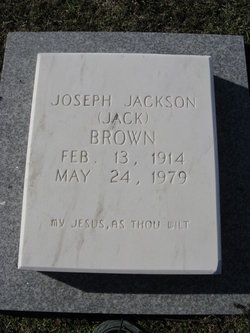
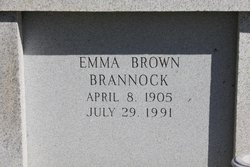
Joseph Jackson “Jack” Brown
| Birth | : | 13 Feb 1914 Patrick County, Virginia, USA |
| Death | : | 24 May 1979 Winston-Salem, Forsyth County, North Carolina, USA |
| Burial | : | All Saint's Churchyard, Ashcott, Sedgemoor District, England |
| Coordinate | : | 51.1309220, -2.8058870 |
| Inscription | : | My Jesus, As Thou Wilt |
frequently asked questions (FAQ):
-
Where is Joseph Jackson “Jack” Brown's memorial?
Joseph Jackson “Jack” Brown's memorial is located at: All Saint's Churchyard, Ashcott, Sedgemoor District, England.
-
When did Joseph Jackson “Jack” Brown death?
Joseph Jackson “Jack” Brown death on 24 May 1979 in Winston-Salem, Forsyth County, North Carolina, USA
-
Where are the coordinates of the Joseph Jackson “Jack” Brown's memorial?
Latitude: 51.1309220
Longitude: -2.8058870
Family Members:
Parent
Spouse
Siblings
Flowers:


Nearby Cemetories:
1. All Saint's Churchyard
Ashcott, Sedgemoor District, England
Coordinate: 51.1309220, -2.8058870
2. Blessed Virgin Mary Churchyard
Shapwick, Sedgemoor District, England
Coordinate: 51.1405090, -2.8336100
3. St. Michael and All Angels Churchyard
Greinton, Sedgemoor District, England
Coordinate: 51.1240140, -2.8408590
4. Holy Trinity Churchyard
Walton, Mendip District, England
Coordinate: 51.1236200, -2.7709580
5. Holy Trinity Churchyard Extension
Walton, Mendip District, England
Coordinate: 51.1234150, -2.7695832
6. Street Cemetery
Street, Mendip District, England
Coordinate: 51.1302840, -2.7508240
7. Blessed Virgin Mary Churchyard
Moorlinch, Sedgemoor District, England
Coordinate: 51.1280000, -2.8616000
8. Saint Peter Churchyard
Catcott, Sedgemoor District, England
Coordinate: 51.1494920, -2.8671220
9. Religious Society of Friends Quaker Cemetery
Street, Mendip District, England
Coordinate: 51.1294100, -2.7375630
10. St. Mary & All Saints Churchyard
Meare, Mendip District, England
Coordinate: 51.1715900, -2.7804100
11. Holy Trinity Churchyard
Street, Mendip District, England
Coordinate: 51.1310100, -2.7330800
12. Saint George Churchyard
Edington, Sedgemoor District, England
Coordinate: 51.1540010, -2.8778350
13. St. Andrew's Churchyard
High Ham, South Somerset District, England
Coordinate: 51.0760320, -2.8218400
14. St Benedict Churchyard
Glastonbury, Mendip District, England
Coordinate: 51.1465970, -2.7196900
15. Saint Andrew Churchyard
Compton Dundon, South Somerset District, England
Coordinate: 51.0897330, -2.7442800
16. Sutton Mallet Churchyard
Sutton Mallet, Sedgemoor District, England
Coordinate: 51.1282540, -2.8974536
17. High Ham Cemetery
High Ham, South Somerset District, England
Coordinate: 51.0739931, -2.8216351
18. Saint John the Baptist Churchyard
Glastonbury, Mendip District, England
Coordinate: 51.1481520, -2.7161400
19. Glastonbury Abbey
Glastonbury, Mendip District, England
Coordinate: 51.1464996, -2.7151000
20. St Edwards Churchyard
Chilton Polden, Sedgemoor District, England
Coordinate: 51.1554490, -2.8972091
21. St. Francis Churchyard
Stawell, Sedgemoor District, England
Coordinate: 51.1404200, -2.9046660
22. Glastonbury Cemetery
Glastonbury, Mendip District, England
Coordinate: 51.1565160, -2.7132380
23. Holy Trinity Church
Godney, Mendip District, England
Coordinate: 51.1793400, -2.7377400
24. St. Philip and St. James Churchyard
Burtle, Sedgemoor District, England
Coordinate: 51.1856232, -2.8665409