
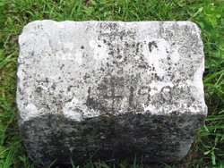
Joseph Winfield Purdy
| Birth | : | 27 Jul 1851 Clayton County, Iowa, USA |
| Death | : | 6 Nov 1905 Spring Creek Township, Black Hawk County, Iowa, USA |
| Burial | : | Colored Asylum Cemetery, Columbia, Richland County, USA |
| Coordinate | : | 34.0244050, -81.0220490 |
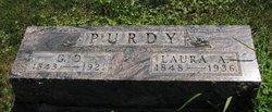
| Description | : | He was married to Esther Wright on December 4, 1892 in Black Hawk County, Iowa. https://waterloo.newspaperarchive.com/waterloo-times-tribune/1905-11-07/ THE DAILY TIMES-TRIBUNE WATERLOO, IOWA TUESDAY MORNING, NOVEMBER 7, 1905 VOLUME 1.NUMBER 31 JOS. W. PURDY IS DEAD Prominent Spring Creek Township Farmer Died Yesterday Afternoon. Special to Daily Times-Tribune Laporte, Nov, 6.—Joseph Winfield Purdy, a prominent resident of Spring Creek township, died at his home, on the old Scroggin farm, at 3 p. m., this afternoon, from consumption. Deceased was born in Clayton county, la., July 27, 1851. In his boyhood, here moved, with his parents, to the western... Read More |
frequently asked questions (FAQ):
-
Where is Joseph Winfield Purdy's memorial?
Joseph Winfield Purdy's memorial is located at: Colored Asylum Cemetery, Columbia, Richland County, USA.
-
When did Joseph Winfield Purdy death?
Joseph Winfield Purdy death on 6 Nov 1905 in Spring Creek Township, Black Hawk County, Iowa, USA
-
Where are the coordinates of the Joseph Winfield Purdy's memorial?
Latitude: 34.0244050
Longitude: -81.0220490
Family Members:
Parent

Spouse
Siblings
Children
Flowers:


Nearby Cemetories:
1. Colored Asylum Cemetery
Columbia, Richland County, USA
Coordinate: 34.0244050, -81.0220490
2. Barhamville Cemetery
Columbia, Richland County, USA
Coordinate: 34.0236870, -81.0107570
3. Crescent Hill Memorial Gardens and Mausoleum
Columbia, Richland County, USA
Coordinate: 34.0297012, -81.0089035
4. Geiger Avenue Cemetery
Columbia, Richland County, USA
Coordinate: 34.0228050, -81.0394590
5. Lincoln Cemetery
Columbia, Richland County, USA
Coordinate: 34.0400009, -81.0214005
6. Miller Cemetery
Columbia, Richland County, USA
Coordinate: 34.0321999, -81.0391998
7. Saint Lukes Episcopal Church Memorial Garden
Columbia, Richland County, USA
Coordinate: 34.0082060, -81.0180940
8. Church of the Good Shepherd Memorial Gardens
Columbia, Richland County, USA
Coordinate: 34.0096610, -81.0316160
9. Ebenezer Lutheran Church Cemetery
Columbia, Richland County, USA
Coordinate: 34.0113680, -81.0361220
10. Mount Pleasant United Methodist Church Cemetery
Columbia, Richland County, USA
Coordinate: 34.0101996, -81.0350037
11. First Baptist Church Cemetery
Columbia, Richland County, USA
Coordinate: 34.0062460, -81.0321850
12. First Presbyterian Churchyard
Columbia, Richland County, USA
Coordinate: 34.0041110, -81.0293900
13. Gunter's Chapel Baptist Church Cemetery
Columbia, Richland County, USA
Coordinate: 34.0394590, -81.0028790
14. Saint Peter's Catholic Church Cemetery
Columbia, Richland County, USA
Coordinate: 34.0052900, -81.0384100
15. Douglass Cemetery
Columbia, Richland County, USA
Coordinate: 34.0180340, -81.0492810
16. Saint Peter's Cemetery
Columbia, Richland County, USA
Coordinate: 34.0119200, -81.0488700
17. Hebrew Benevolent Society Cemetery
Columbia, Richland County, USA
Coordinate: 34.0049780, -81.0435680
18. Elmwood Memorial Gardens
Columbia, Richland County, USA
Coordinate: 34.0121000, -81.0523200
19. Promised Land Cemetery
Columbia, Richland County, USA
Coordinate: 34.0423830, -80.9960170
20. Eastminster Presbyterian Church Columbarium
Columbia, Richland County, USA
Coordinate: 34.0079530, -80.9942360
21. Palmetto Cemetery
Columbia, Richland County, USA
Coordinate: 34.0521785, -81.0290293
22. Antioch Baptist Church Cemetery
Columbia, Richland County, USA
Coordinate: 34.0525790, -81.0114780
23. Randolph Cemetery
Columbia, Richland County, USA
Coordinate: 34.0093500, -81.0540800
24. Pine Ridge Cemetery
Columbia, Richland County, USA
Coordinate: 34.0539017, -81.0124969