
| Birth | : | 20 Jan 1831 Norridgewock, Somerset County, Maine, USA |
| Death | : | 9 Feb 1917 Los Angeles, Los Angeles County, California, USA |
| Burial | : | Portsmouth Naval Memorial, Portsmouth, Portsmouth Unitary Authority, England |
| Coordinate | : | 50.7824440, -1.0957720 |
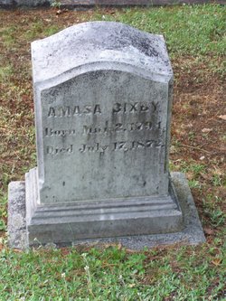
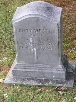
| Description | : | "Father of the City of Long Beach" ____________________________ Father: Amasa Bixby Mother: Fanny Weston Spouse: Margaret Hathaway ____________________________ Jotham Bixby started buying land on the Palos Verdes Peninsula in the 1870s. On September 25, 1882, Jotham acquired over 17,000 acres of Rancho Los Palos Verdes, which was half of the original land grant given to Jose Delores Sepulveda. This land was awarded to Bixby as a result of a Superior Court Decree order ordering the foreclosure of the property owned by the Sepulveda heirs. Bixby used the rolling hills of this acreage to graze his cattle. It was 1885, when Jotham and his family... Read More |
frequently asked questions (FAQ):
-
Where is Jotham Bixby's memorial?
Jotham Bixby's memorial is located at: Portsmouth Naval Memorial, Portsmouth, Portsmouth Unitary Authority, England.
-
When did Jotham Bixby death?
Jotham Bixby death on 9 Feb 1917 in Los Angeles, Los Angeles County, California, USA
-
Where are the coordinates of the Jotham Bixby's memorial?
Latitude: 50.7824440
Longitude: -1.0957720
Family Members:
Parent
Spouse

Siblings
Children
Flowers:


Nearby Cemetories:
1. Portsmouth Naval Memorial
Portsmouth, Portsmouth Unitary Authority, England
Coordinate: 50.7824440, -1.0957720
2. Royal Garrison Church Churchyard
Plymouth, Plymouth Unitary Authority, England
Coordinate: 50.7889690, -1.1039650
3. Royal Garrison Churchyard
Portsmouth, Portsmouth Unitary Authority, England
Coordinate: 50.7890180, -1.1040520
4. Portsmouth Cathedral Churchyard
Portsmouth, Portsmouth Unitary Authority, England
Coordinate: 50.7904650, -1.1043720
5. Portsmouth Unitarian Church
Portsmouth, Portsmouth Unitary Authority, England
Coordinate: 50.7915640, -1.1011840
6. Old Jewish Cemetery
Portsmouth, Portsmouth Unitary Authority, England
Coordinate: 50.7887000, -1.0738800
7. HMS Victoria Monument
Portsmouth, Portsmouth Unitary Authority, England
Coordinate: 50.7997200, -1.0950800
8. Highland Road Cemetery
Portsmouth, Portsmouth Unitary Authority, England
Coordinate: 50.7860500, -1.0671790
9. Holy Trinity Churchyard
Gosport, Gosport Borough, England
Coordinate: 50.7930600, -1.1207620
10. HMS Victory Ship
Portsmouth, Portsmouth Unitary Authority, England
Coordinate: 50.8017290, -1.1095590
11. St. Mary's Churchyard
Portsea, Portsmouth Unitary Authority, England
Coordinate: 50.8035350, -1.0763490
12. Clayhall Naval Cemetery
Gosport, Gosport Borough, England
Coordinate: 50.7833862, -1.1373420
13. St James Churchyard
Eastney, Portsmouth Unitary Authority, England
Coordinate: 50.7940650, -1.0581150
14. Turkish Naval Cemetery
Gosport, Gosport Borough, England
Coordinate: 50.7840710, -1.1383980
15. Kingston Cemetery
Portsmouth, Portsmouth Unitary Authority, England
Coordinate: 50.8031440, -1.0683260
16. Milton Cemetery
Portsmouth, Portsmouth Unitary Authority, England
Coordinate: 50.7988700, -1.0608030
17. Mile End Cemetery
Portsea, Portsmouth Unitary Authority, England
Coordinate: 50.8108900, -1.0876400
18. St. Mark's Churchyard
Alverstoke, Gosport Borough, England
Coordinate: 50.7826800, -1.1436100
19. St John the Evangelist Churchyard
Gosport, Gosport Borough, England
Coordinate: 50.7995600, -1.1397800
20. St Mary Churchyard
Alverstoke, Gosport Borough, England
Coordinate: 50.7856760, -1.1480810
21. Ann's Hill Cemetery
Gosport, Gosport Borough, England
Coordinate: 50.7982670, -1.1549450
22. St Thomas the Apostle Churchyard
Gosport, Gosport Borough, England
Coordinate: 50.8137570, -1.1484570
23. St. Mary's Churchyard
Portchester, Fareham Borough, England
Coordinate: 50.8366280, -1.1134270
24. St Mary the Virgin Churchyard
Gosport, Gosport Borough, England
Coordinate: 50.8112690, -1.1724800