
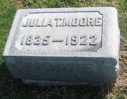
Julia Ann Thomas Moore
| Birth | : | 16 Dec 1837 Indiana, USA |
| Death | : | 22 Oct 1922 Indiana, USA |
| Burial | : | St Wilfrid's Churchyard, Halton, City of Lancaster, England |
| Coordinate | : | 54.0759400, -2.7672600 |
| Plot | : | Section 3 |
| Description | : | d/o Thomas Thomas & Jane Harlan Sullivan Daily Times Monday, October 23, 1922 Mrs. Julia T. Moore Called to Reward Pioneer Resident of County Dies at Advanced Age of 86 Mrs. Julia Thomas Moore, widow of William M. Moore, a pioneer resident of Sullivan county, passed away Sunday night at the home of her daughter, Mrs. James Woner north of Graysville. Mrs. Moore, who was eighty six years old, is survived by two children, Mrs. Esther Woner of near Graysville and Thomas Moore of this city. She was an aunt of Mrs. James Lang, Mrs. John Ersinger and Mrs. Clayton Price of... Read More |
frequently asked questions (FAQ):
-
Where is Julia Ann Thomas Moore's memorial?
Julia Ann Thomas Moore's memorial is located at: St Wilfrid's Churchyard, Halton, City of Lancaster, England.
-
When did Julia Ann Thomas Moore death?
Julia Ann Thomas Moore death on 22 Oct 1922 in Indiana, USA
-
Where are the coordinates of the Julia Ann Thomas Moore's memorial?
Latitude: 54.0759400
Longitude: -2.7672600
Family Members:
Spouse
Children

Flowers:


Nearby Cemetories:
1. St Wilfrid's Churchyard
Halton, City of Lancaster, England
Coordinate: 54.0759400, -2.7672600
2. Skerton Cemetery
Lancaster, City of Lancaster, England
Coordinate: 54.0651430, -2.7951140
3. Slyne Cemetery
Slyne, City of Lancaster, England
Coordinate: 54.0868185, -2.7969423
4. Lancaster Cemetery
Lancaster, City of Lancaster, England
Coordinate: 54.0504210, -2.7768760
5. Saint Luke's Parish Churchyard
Skerton, City of Lancaster, England
Coordinate: 54.0564700, -2.7982600
6. Christ Church United Reform Church
Bolton-le-Sands, City of Lancaster, England
Coordinate: 54.1015860, -2.7929000
7. Holy Trinity Churchyard
Bolton-le-Sands, City of Lancaster, England
Coordinate: 54.1027700, -2.7911700
8. Nether Kellet Congregational Church
Nether Kellet, City of Lancaster, England
Coordinate: 54.1070772, -2.7587630
9. St. John the Evangelist Churchyard
Lancaster, City of Lancaster, England
Coordinate: 54.0504000, -2.7990000
10. Lancaster and Morecambe Crematorium
Lancaster, City of Lancaster, England
Coordinate: 54.0650890, -2.8198420
11. Cathedral Cemetery of Lancaster
Lancaster, City of Lancaster, England
Coordinate: 54.0471170, -2.7942920
12. St. Nicholas Street Chapel Churchyard
Lancaster, City of Lancaster, England
Coordinate: 54.0486900, -2.7987900
13. Lancaster Priory
Lancaster, City of Lancaster, England
Coordinate: 54.0507360, -2.8057850
14. Lancaster Castle Cemetery
Lancaster, City of Lancaster, England
Coordinate: 54.0494330, -2.8047890
15. Friends Meeting House Burial Ground
Lancaster, City of Lancaster, England
Coordinate: 54.0482500, -2.8058025
16. Mount Street Congregational Chapel
Lancaster, City of Lancaster, England
Coordinate: 54.0468260, -2.8027430
17. St. Paul Churchyard
Caton, City of Lancaster, England
Coordinate: 54.0757840, -2.7009980
18. St Peter's Churchyard
Quernmore, City of Lancaster, England
Coordinate: 54.0367200, -2.7375400
19. Torrisholme Cemetery
Morecambe, City of Lancaster, England
Coordinate: 54.0638980, -2.8409800
20. St Cuthbert Churchyard
Over Kellet, City of Lancaster, England
Coordinate: 54.1195480, -2.7318200
21. Carnforth Cemetery
Carnforth, City of Lancaster, England
Coordinate: 54.1245420, -2.7587820
22. Scotforth Cemetery
Scotforth, City of Lancaster, England
Coordinate: 54.0282250, -2.8007170
23. Holy Trinity Church Poulton-le-Sands
Morecambe, City of Lancaster, England
Coordinate: 54.0744769, -2.8569331
24. Morecambe Cemetery
Morecambe, City of Lancaster, England
Coordinate: 54.0759090, -2.8572610