
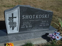
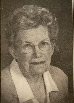
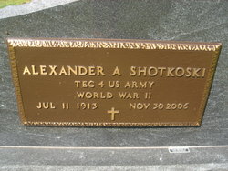
Julia Joan Krzycki Shotkoski
| Birth | : | 20 Apr 1923 Nance County, Nebraska, USA |
| Death | : | 29 Jul 2015 Ord, Valley County, Nebraska, USA |
| Burial | : | Saint Josaphats Cemetery, Loup City, Sherman County, USA |
| Coordinate | : | 41.3022003, -98.9847031 |
| Description | : | Julia J. Shotkoski 92 of Loup City, NE died Thursday, July 30, 2015 at Valley View Living Center at Ord, NE. Our dear mother, Julia is now holding her husband, Alex’s hand in heaven. Funeral services will be 10:30 a.m. Tuesday, August 4, 2015 at St. Josaphat’s Catholic Church in Loup City with Father Martin Egging officiating. Burial will be held at the Evergreen Cemetery at Loup City. Visitation will be from 5:00 p.m. to 7:00 p.m. Monday, August 3, 2015 at the church with a Vigil Service/Sodality Rosary to be held at 7:00 p.m. at... Read More |
frequently asked questions (FAQ):
-
Where is Julia Joan Krzycki Shotkoski's memorial?
Julia Joan Krzycki Shotkoski's memorial is located at: Saint Josaphats Cemetery, Loup City, Sherman County, USA.
-
When did Julia Joan Krzycki Shotkoski death?
Julia Joan Krzycki Shotkoski death on 29 Jul 2015 in Ord, Valley County, Nebraska, USA
-
Where are the coordinates of the Julia Joan Krzycki Shotkoski's memorial?
Latitude: 41.3022003
Longitude: -98.9847031
Family Members:
Parent

Spouse
Siblings
Flowers:


Nearby Cemetories:
1. Saint Josaphats Cemetery
Loup City, Sherman County, USA
Coordinate: 41.3022003, -98.9847031
2. Evergreen Cemetery
Loup City, Sherman County, USA
Coordinate: 41.2997017, -98.9852982
3. Sunny Slope Cemetery
Loup City, Sherman County, USA
Coordinate: 41.2906000, -99.0267000
4. Cleoria Cemetery
Loup City, Sherman County, USA
Coordinate: 41.2779000, -99.0893500
5. Balsora Cemetery
Sherman County, USA
Coordinate: 41.3782997, -99.0975037
6. Austin Cemetery
Rockville, Sherman County, USA
Coordinate: 41.1880989, -98.8981018
7. Verdurette Cemetery
Sherman County, USA
Coordinate: 41.1697006, -98.9757996
8. Davis Creek Cemetery
Valley County, USA
Coordinate: 41.4219017, -98.9052963
9. Saint Francis Cemetery
Ashton, Sherman County, USA
Coordinate: 41.2438000, -98.7994000
10. Lone Elm Cemetery
Loup City, Sherman County, USA
Coordinate: 41.2921982, -99.1864014
11. Immanuel Lutheran Cemetery
Ashton, Sherman County, USA
Coordinate: 41.2140000, -98.8142000
12. Arcadia Cemetery
Arcadia, Valley County, USA
Coordinate: 41.4237000, -99.1167000
13. Gray Cemetery
Sherman County, USA
Coordinate: 41.2099991, -99.1567001
14. Pleasant Hill Friends Cemetery
Valley County, USA
Coordinate: 41.4230800, -98.8377700
15. Dunkard Cemetery
Arcadia, Valley County, USA
Coordinate: 41.4522000, -99.0769000
16. Union Cemetery
Ashton, Sherman County, USA
Coordinate: 41.2214012, -98.7855988
17. Litchfield Cemetery
Litchfield, Sherman County, USA
Coordinate: 41.1543999, -99.1283035
18. Mount Carmel Cemetery
Howard County, USA
Coordinate: 41.2797012, -98.7328033
19. Salem Evangelical Church Cemetery
Ord, Valley County, USA
Coordinate: 41.4902992, -98.9244003
20. Lewis Burial Plat
Litchfield, Sherman County, USA
Coordinate: 41.1383000, -99.1484000
21. Lee Park Cemetery
Custer County, USA
Coordinate: 41.4025002, -99.2307968
22. Trinity Lutheran Church Cemetery
Hazard, Sherman County, USA
Coordinate: 41.0913000, -99.0052000
23. Lee Park Catholic Cemetery
Westerville, Custer County, USA
Coordinate: 41.4091988, -99.2311020
24. Dannevirke Cemetery
Dannevirke, Howard County, USA
Coordinate: 41.3227997, -98.6986008