
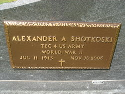

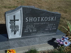
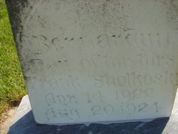
Alexander Adam “Alex” Shotkoski
| Birth | : | 11 Jul 1913 Nance County, Nebraska, USA |
| Death | : | 30 Nov 2006 Kearney, Buffalo County, Nebraska, USA |
| Burial | : | Herne Bay Cemetery, Herne Bay, City of Canterbury, England |
| Coordinate | : | 51.3571810, 1.1304820 |
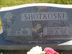
| Description | : | Son of Frank & Veronica (Kuta) Shotkoski. Married to Julia Jean Krzycki on 6-15-1946 at St. Rose of Lima Catholic Church at Genoa, NE. Occupation - Farmer |
frequently asked questions (FAQ):
-
Where is Alexander Adam “Alex” Shotkoski's memorial?
Alexander Adam “Alex” Shotkoski's memorial is located at: Herne Bay Cemetery, Herne Bay, City of Canterbury, England.
-
When did Alexander Adam “Alex” Shotkoski death?
Alexander Adam “Alex” Shotkoski death on 30 Nov 2006 in Kearney, Buffalo County, Nebraska, USA
-
Where are the coordinates of the Alexander Adam “Alex” Shotkoski's memorial?
Latitude: 51.3571810
Longitude: 1.1304820
Family Members:
Parent

Spouse
Siblings
Flowers:


Nearby Cemetories:
1. Herne Bay Cemetery
Herne Bay, City of Canterbury, England
Coordinate: 51.3571810, 1.1304820
2. St Martins
Herne, City of Canterbury, England
Coordinate: 51.3500600, 1.1333200
3. St Martin's Churchyard
Herne, City of Canterbury, England
Coordinate: 51.3497060, 1.1334370
4. St Mary the Virgin Churchyard
Reculver, City of Canterbury, England
Coordinate: 51.3684750, 1.1766050
5. St John the Baptist Churchyard
Swalecliffe, City of Canterbury, England
Coordinate: 51.3645500, 1.0667200
6. St Mary The Virgin Churchyard
Chislet, City of Canterbury, England
Coordinate: 51.3343610, 1.1921020
7. St Mary's Abbey
Reculver, City of Canterbury, England
Coordinate: 51.3795360, 1.1993770
8. All Saints Churchyard
Westbere, City of Canterbury, England
Coordinate: 51.3065380, 1.1437670
9. Sturry Cemetery
Sturry, City of Canterbury, England
Coordinate: 51.3058100, 1.1277700
10. All Saints Churchyard
Whitstable, City of Canterbury, England
Coordinate: 51.3558090, 1.0396670
11. St Nicholas Churchyard
Sturry, City of Canterbury, England
Coordinate: 51.2984830, 1.1201330
12. Whitstable Cemetery
Whitstable, City of Canterbury, England
Coordinate: 51.3529870, 1.0338530
13. St Mary the Virgin Churchyard
Fordwich, City of Canterbury, England
Coordinate: 51.2958300, 1.1270530
14. Stodmarsh St Marys Churchyard
Wickhambreaux, City of Canterbury, England
Coordinate: 51.3009500, 1.1836900
15. St Alphege Churchyard
Whitstable, City of Canterbury, England
Coordinate: 51.3576330, 1.0251080
16. St Cosmus and St Damian Churchyard
Blean, City of Canterbury, England
Coordinate: 51.3052720, 1.0530480
17. St. Nicholas' Churchyard
St Nicholas at Wade, Thanet District, England
Coordinate: 51.3542160, 1.2517980
18. All Saints Churchyard
Stourmouth, Dover District, England
Coordinate: 51.3202600, 1.2365520
19. St Nicholas-at-Wade Cemetery
St Nicholas at Wade, Thanet District, England
Coordinate: 51.3578344, 1.2534168
20. St Gregory's Priory (defunct)
Canterbury, City of Canterbury, England
Coordinate: 51.2831127, 1.0855358
21. St. John the Baptist Hospital Chapelyard
Canterbury, City of Canterbury, England
Coordinate: 51.2832713, 1.0837677
22. St Andrew Churchyard
Wickhambreaux, City of Canterbury, England
Coordinate: 51.2844400, 1.1822300
23. St Gregory Churchyard
Canterbury, City of Canterbury, England
Coordinate: 51.2816050, 1.0887840
24. St Mildred Churchyard
Preston, Dover District, England
Coordinate: 51.2985000, 1.2173980