
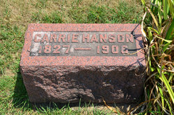
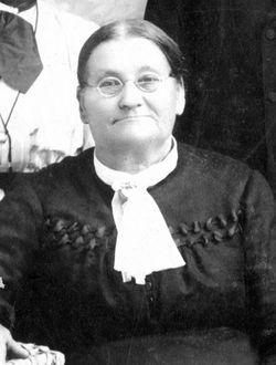
Karin “Carrie” Nilsdotter Hanson
| Birth | : | 7 Sep 1827 Åmot, Ockelbo kommun, Gävleborgs län, Sweden |
| Death | : | 5 Mar 1906 Hardin Township, Webster County, Iowa, USA |
| Burial | : | Dayton Cemetery, Dayton, Webster County, USA |
| Coordinate | : | 42.2675000, -94.0755000 |
| Plot | : | Section 1 |
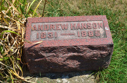
| Description | : | Dayton Review March 22, 1906 Obituary Mrs. Carrie Hanson was born in Amot, Gästrickland, Gävleborgs Län, Sweden, September 7, 1827, and died in Swede Bend, March 5, 1906 at the age of 78 years, 5 months and 28 days. Deceased was united in marriage to Andrew Hanson in the year of 1852. Two children were born unto them. They emigrated to America in 1884, located near Dayton, Iowa. Her husband died the following year, 1885 and her son died five years ago. She has been a Christian many years and it was her greatest desire to... Read More |
frequently asked questions (FAQ):
-
Where is Karin “Carrie” Nilsdotter Hanson's memorial?
Karin “Carrie” Nilsdotter Hanson's memorial is located at: Dayton Cemetery, Dayton, Webster County, USA.
-
When did Karin “Carrie” Nilsdotter Hanson death?
Karin “Carrie” Nilsdotter Hanson death on 5 Mar 1906 in Hardin Township, Webster County, Iowa, USA
-
Where are the coordinates of the Karin “Carrie” Nilsdotter Hanson's memorial?
Latitude: 42.2675000
Longitude: -94.0755000
Family Members:
Parent

Spouse
Siblings
Children
Flowers:


Nearby Cemetories:
1. Dayton Cemetery
Dayton, Webster County, USA
Coordinate: 42.2675000, -94.0755000
2. Christ the King Catholic Cemetery
Dayton, Webster County, USA
Coordinate: 42.2601929, -94.0727539
3. Bass Cemetery
Dayton, Webster County, USA
Coordinate: 42.2966995, -94.0149994
4. Swedish Lutheran Church Cemetery
Dayton, Webster County, USA
Coordinate: 42.2175000, -94.1065000
5. Oak Grove Cemetery
Lehigh, Webster County, USA
Coordinate: 42.3438988, -94.0475006
6. Hardin Township Cemetery
Hardin Township, Webster County, USA
Coordinate: 42.2411003, -93.9708023
7. Linn Cemetery
Pilot Mound, Boone County, USA
Coordinate: 42.2045330, -93.9970230
8. Lawn Cemetery
Boone County, USA
Coordinate: 42.1771011, -94.0867996
9. West Lawn Cemetery
Lehigh, Webster County, USA
Coordinate: 42.3616982, -94.0678024
10. McGuire Bend Cemetery
Dayton, Webster County, USA
Coordinate: 42.3410000, -93.9880000
11. Runyan Cemetery
Pilot Mound, Boone County, USA
Coordinate: 42.1749992, -94.0015030
12. Pilot Mound Cemetery
Pilot Mound, Boone County, USA
Coordinate: 42.1636200, -94.0282600
13. Vegors Cemetery
Webster County, USA
Coordinate: 42.3177986, -93.9421997
14. Lost Grove Cemetery
Harcourt, Webster County, USA
Coordinate: 42.2583008, -94.2331009
15. Hooks Point Cemetery
Hamilton County, USA
Coordinate: 42.2944530, -93.9199090
16. Oakwood Cemetery
Stratford, Hamilton County, USA
Coordinate: 42.2942009, -93.9182968
17. Hartman Cemetery
Lehigh, Webster County, USA
Coordinate: 42.3666397, -93.9835627
18. White Cemetery
Boone County, USA
Coordinate: 42.1777992, -93.9636002
19. Border Plains Cemetery
Border Plains, Webster County, USA
Coordinate: 42.3917000, -94.0448000
20. Ober and Scott Cemetery
Duncombe, Webster County, USA
Coordinate: 42.3841390, -93.9982856
21. Union Cemetery
Boxholm, Boone County, USA
Coordinate: 42.1369019, -94.0852966
22. Renner Cemetery
Boone County, USA
Coordinate: 42.1380420, -94.1256570
23. Otho Cemetery
Otho, Webster County, USA
Coordinate: 42.4025002, -94.1153030
24. Schlicht Cemetery
Fraser, Boone County, USA
Coordinate: 42.1444200, -93.9780100