
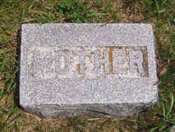
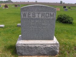
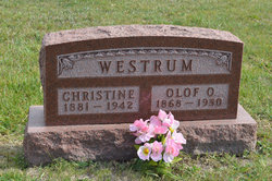
Karin “Carrie” Nyblom Westrom
| Birth | : | 17 Jun 1847 Alfta, Ovanåkers kommun, Gävleborgs län, Sweden |
| Death | : | 28 Feb 1920 Stratford, Hamilton County, Iowa, USA |
| Burial | : | South Marion Cemetery, Stratford, Hamilton County, USA |
| Coordinate | : | 42.2327995, -93.8735962 |
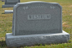
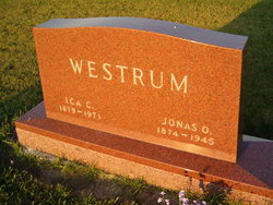
| Description | : | Stratford Courier March 4, 1920 RESPECTED AND AGED LADY PASSES TO HER REWARD SATURDAY Mrs. Olof Westrum passed away Saturday night at her home here after having become suddenly ill in the morning. For many months deceased had been ailing though the most of the time she was able to be about her home. However, her death came as a saddening blow to the loved ones. Deceased was one of those motherly old souls whose great joy during her declining years has been to watch over and care for those who were near and dear to her.... Read More |
frequently asked questions (FAQ):
-
Where is Karin “Carrie” Nyblom Westrom's memorial?
Karin “Carrie” Nyblom Westrom's memorial is located at: South Marion Cemetery, Stratford, Hamilton County, USA.
-
When did Karin “Carrie” Nyblom Westrom death?
Karin “Carrie” Nyblom Westrom death on 28 Feb 1920 in Stratford, Hamilton County, Iowa, USA
-
Where are the coordinates of the Karin “Carrie” Nyblom Westrom's memorial?
Latitude: 42.2327995
Longitude: -93.8735962
Family Members:
Parent
Spouse
Siblings
Children
Flowers:


Nearby Cemetories:
1. South Marion Cemetery
Stratford, Hamilton County, USA
Coordinate: 42.2327995, -93.8735962
2. Oakwood Cemetery
Stratford, Hamilton County, USA
Coordinate: 42.2942009, -93.9182968
3. Mineral Ridge Cemetery
Ridgeport, Boone County, USA
Coordinate: 42.1749992, -93.9266968
4. Hooks Point Cemetery
Hamilton County, USA
Coordinate: 42.2944530, -93.9199090
5. Hardin Township Cemetery
Hardin Township, Webster County, USA
Coordinate: 42.2411003, -93.9708023
6. Saint Paul Lutheran Cemetery
Boone, Boone County, USA
Coordinate: 42.1700000, -93.8070000
7. Boone County Poor Farm Cemetery
Boone County, USA
Coordinate: 42.1591100, -93.9159000
8. White Cemetery
Boone County, USA
Coordinate: 42.1777992, -93.9636002
9. Lake Center Cemetery
Stanhope, Hamilton County, USA
Coordinate: 42.2482986, -93.7568970
10. Leininger Cemetery
Boone County, USA
Coordinate: 42.1492004, -93.8356018
11. Lawn Hill Cemetery
Stanhope, Hamilton County, USA
Coordinate: 42.2677994, -93.7611008
12. Nesse Cemetery
Hamilton County, USA
Coordinate: 42.3250008, -93.8933029
13. Neese Cemetery
Homer, Hamilton County, USA
Coordinate: 42.3250000, -93.8935000
14. Linn Cemetery
Pilot Mound, Boone County, USA
Coordinate: 42.2045330, -93.9970230
15. Vegors Cemetery
Webster County, USA
Coordinate: 42.3177986, -93.9421997
16. Mackey Cemetery
Boone County, USA
Coordinate: 42.1675000, -93.7565000
17. Runyan Cemetery
Pilot Mound, Boone County, USA
Coordinate: 42.1749992, -94.0015030
18. Saint Pauls Church Cemetery
Jewell, Hamilton County, USA
Coordinate: 42.2490100, -93.7173400
19. Schlicht Cemetery
Fraser, Boone County, USA
Coordinate: 42.1444200, -93.9780100
20. Bass Cemetery
Dayton, Webster County, USA
Coordinate: 42.2966995, -94.0149994
21. Saratoga Cemetery
Stanhope, Hamilton County, USA
Coordinate: 42.3539009, -93.8167038
22. Pilot Mound Cemetery
Pilot Mound, Boone County, USA
Coordinate: 42.1636200, -94.0282600
23. Ellsworth Clear Lake Cemetery
Randall, Hamilton County, USA
Coordinate: 42.2268930, -93.6926200
24. Bass Point Cemetery
Boone, Boone County, USA
Coordinate: 42.0992012, -93.8957977