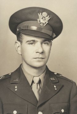
Katherine Mae Wegner Metzger
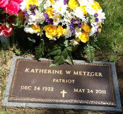
| Birth | : | 24 Dec 1922 Council Bluffs, Pottawattamie County, Iowa, USA |
| Death | : | 24 May 2011 Louisville, Cass County, Nebraska, USA |
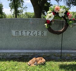
| Burial | : | Oak Hill Cemetery, Plattsmouth, Cass County, USA |
| Coordinate | : | 41.0106010, -95.9124985 |
| Description | : | Katherine Wegner Metzger, of Cedar Creek, NE passed away at the Louisville Care Community on Tuesday, May 24, 2011, where she had resided since April 2009. Katherine was born on December 24, 1922, in Council Bluffs, to Edward F. and Dorothy (Donahue) Wegner. She was raised and schooled in Council Bluffs, graduating from Abraham Lincoln High School. Katherine was engaged to John Hildebrand of New York City. John was killed in action during World War II while aboard a Naval Ship that was hit by a Japanese Torpedo. She later met Captain William A Metzger and they were married on... Read More |
frequently asked questions (FAQ):
-
Where is Katherine Mae Wegner Metzger's memorial?
Katherine Mae Wegner Metzger's memorial is located at: Oak Hill Cemetery, Plattsmouth, Cass County, USA.
-
When did Katherine Mae Wegner Metzger death?
Katherine Mae Wegner Metzger death on 24 May 2011 in Louisville, Cass County, Nebraska, USA
-
Where are the coordinates of the Katherine Mae Wegner Metzger's memorial?
Latitude: 41.0106010
Longitude: -95.9124985
Family Members:
Parent
Spouse
Siblings
Flowers:
Nearby Cemetories:
1. Holy Sepulchre Cemetery
Plattsmouth, Cass County, USA
Coordinate: 41.0122660, -95.9128240
2. Billings Cemetery
Plattsmouth, Cass County, USA
Coordinate: 41.0025000, -95.8897000
3. Pleasant Ridge Cemetery
Plattsmouth, Cass County, USA
Coordinate: 40.9735985, -95.8827972
4. LaPlatte Cemetery
La Platte, Sarpy County, USA
Coordinate: 41.0694008, -95.9336014
5. Doom Family Cemetery
Cass County, USA
Coordinate: 40.9550000, -95.8575000
6. Youngs Cemetery
Murray, Cass County, USA
Coordinate: 40.9406013, -95.9039001
7. Clemmons Cemetery
Murray, Cass County, USA
Coordinate: 40.9300003, -95.8961029
8. Eight Mile Grove Cemetery
Cass County, USA
Coordinate: 40.9509239, -95.9979324
9. Martin Chapel Cemetery
Pacific City, Mills County, USA
Coordinate: 41.0611000, -95.8013992
10. Godsey Cemetery
Mills County, USA
Coordinate: 41.0705986, -95.8075027
11. Gowens-Turner Cemetery
Glenwood, Mills County, USA
Coordinate: 41.0715510, -95.7952420
12. Rock Bluff Cemetery
Plattsmouth, Cass County, USA
Coordinate: 40.9150009, -95.8469009
13. Van Eaton Cemetery
Pacific Junction, Mills County, USA
Coordinate: 40.9388800, -95.7919400
14. Offutt AFB Cemetery
Sarpy County, USA
Coordinate: 41.1325607, -95.9096451
15. Anderson Grove Cemetery
Bellevue, Sarpy County, USA
Coordinate: 41.1285286, -95.9670334
16. Lewiston Cemetery
Union, Cass County, USA
Coordinate: 40.8856087, -95.8936539
17. Tunison Cemetery
Bellevue, Sarpy County, USA
Coordinate: 41.1357570, -95.9481150
18. Wall Cemetery
Mineola, Mills County, USA
Coordinate: 41.1157990, -95.8153000
19. Columban Martyrs Memorial Garden
Bellevue, Sarpy County, USA
Coordinate: 41.1403220, -95.9034390
20. Moscrip Cemetery
Bellevue, Sarpy County, USA
Coordinate: 41.1413500, -95.8917000
21. Glenwood Cemetery
Glenwood, Mills County, USA
Coordinate: 41.0599670, -95.7480240
22. Glenwood Catholic Cemetery
Glenwood, Mills County, USA
Coordinate: 41.0600000, -95.7453000
23. Glenwood Resource Center Cemetery
Glenwood, Mills County, USA
Coordinate: 41.0361720, -95.7338590
24. Church of the Holy Spirit Columbarium
Bellevue, Sarpy County, USA
Coordinate: 41.1475000, -95.9244000

