
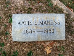
Katie E Ramsey Maness
| Birth | : | 18 Mar 1886 Shelby, Cleveland County, North Carolina, USA |
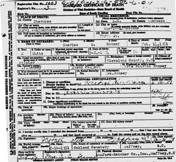
| Death | : | 19 Apr 1959 Gaffney, Cherokee County, South Carolina, USA |
| Burial | : | All Saints Churchyard, Banstead, Reigate and Banstead Borough, England |
| Coordinate | : | 51.3220583, -0.2008833 |
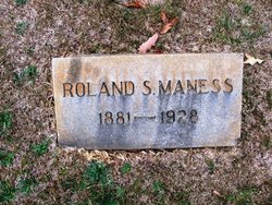
| Description | : | Wife of Roland Samuel Maness. Daughter of M. P. Ramsey & Susan Padgett Ramsey. |
frequently asked questions (FAQ):
-
Where is Katie E Ramsey Maness's memorial?
Katie E Ramsey Maness's memorial is located at: All Saints Churchyard, Banstead, Reigate and Banstead Borough, England.
-
When did Katie E Ramsey Maness death?
Katie E Ramsey Maness death on 19 Apr 1959 in Gaffney, Cherokee County, South Carolina, USA
-
Where are the coordinates of the Katie E Ramsey Maness's memorial?
Latitude: 51.3220583
Longitude: -0.2008833
Family Members:
Parent

Spouse
Siblings

Flowers:


Nearby Cemetories:
1. All Saints Churchyard
Banstead, Reigate and Banstead Borough, England
Coordinate: 51.3220583, -0.2008833
2. St Ann's Memorial Garden
Banstead, Reigate and Banstead Borough, England
Coordinate: 51.3215180, -0.2120434
3. Banstead Hospital Cemetery
Banstead, Reigate and Banstead Borough, England
Coordinate: 51.3389400, -0.1849100
4. St Peter's Churchyard
Woodmansterne, Reigate and Banstead Borough, England
Coordinate: 51.3246900, -0.1693300
5. Epsom Cemetery
Epsom, Epsom and Ewell Borough, England
Coordinate: 51.3198040, -0.2594180
6. St. Martin of Tours Churchyard
Epsom, Epsom and Ewell Borough, England
Coordinate: 51.3306847, -0.2593640
7. St. Margaret's Churchyard
Hooley, Reigate and Banstead Borough, England
Coordinate: 51.2923980, -0.1602950
8. St Dunstan Churchyard
Cheam, London Borough of Sutton, England
Coordinate: 51.3607000, -0.2163720
9. St Mary the Virgin Churchyard
Ewell, Epsom and Ewell Borough, England
Coordinate: 51.3490283, -0.2495934
10. All Saints Churchyard
Carshalton, London Borough of Sutton, England
Coordinate: 51.3648780, -0.1630820
11. Saint Peter's Church
Walton-on-the-Hill, Reigate and Banstead Borough, England
Coordinate: 51.2817810, -0.2467230
12. All Saints Churchyard
Benhilton, London Borough of Sutton, England
Coordinate: 51.3726540, -0.1932910
13. Horton Estate Cemetery
Epsom, Epsom and Ewell Borough, England
Coordinate: 51.3527020, -0.2762460
14. Sutton Cemetery
Sutton, London Borough of Sutton, England
Coordinate: 51.3785800, -0.2056800
15. St Giles Churchyard
Ashtead, Mole Valley District, England
Coordinate: 51.3086540, -0.2900093
16. Christ Church with St Philip
Worcester Park, London Borough of Sutton, England
Coordinate: 51.3762000, -0.2358800
17. St James' Church Riddlesdown
Caterham, Tandridge District, England
Coordinate: 51.3302800, -0.1075140
18. Cuddington Cemetery
Worcester Park, London Borough of Sutton, England
Coordinate: 51.3774030, -0.2367030
19. Chaldon Saint Peter and Saint Paul Churchyard
Whyteleafe, Tandridge District, England
Coordinate: 51.2852778, -0.1248302
20. Bandon Hill Cemetery
Wallington, London Borough of Sutton, England
Coordinate: 51.3655780, -0.1324900
21. St Katharine's Churchyard
Merstham, Reigate and Banstead Borough, England
Coordinate: 51.2689900, -0.1514700
22. St Marys Churchyard
Headley, Mole Valley District, England
Coordinate: 51.2799700, -0.2736100
23. St Mary the Virgin Churchyard
Beddington, London Borough of Sutton, England
Coordinate: 51.3714040, -0.1400730
24. St. Lawrence's Hospital Burial Ground
Caterham, Tandridge District, England
Coordinate: 51.2878640, -0.1079560