
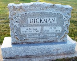

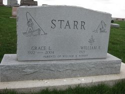
LaMena Vietta Carney Dickman
| Birth | : | 29 Jun 1911 Fredericksburg, Chickasaw County, Iowa, USA |
| Death | : | 8 Jan 2006 Clarksville, Butler County, Iowa, USA |
| Burial | : | Holy Trinity Churchyard, Queenborough, Swale Borough, England |
| Coordinate | : | 51.4174080, 0.7443560 |
| Description | : | daughter of William H. and Carrie M. (Taylor) Carney |
frequently asked questions (FAQ):
-
Where is LaMena Vietta Carney Dickman's memorial?
LaMena Vietta Carney Dickman's memorial is located at: Holy Trinity Churchyard, Queenborough, Swale Borough, England.
-
When did LaMena Vietta Carney Dickman death?
LaMena Vietta Carney Dickman death on 8 Jan 2006 in Clarksville, Butler County, Iowa, USA
-
Where are the coordinates of the LaMena Vietta Carney Dickman's memorial?
Latitude: 51.4174080
Longitude: 0.7443560
Family Members:
Parent

Spouse

Siblings
Children
Flowers:


Nearby Cemetories:
1. Holy Trinity Churchyard
Queenborough, Swale Borough, England
Coordinate: 51.4174080, 0.7443560
2. Sheppey Cemetery
Sheerness, Swale Borough, England
Coordinate: 51.4232780, 0.7718320
3. All Saints Churchyard
Iwade, Swale Borough, England
Coordinate: 51.3787920, 0.7306550
4. Ss Mary and Sexburga New Churchyard
Minster on Sea, Swale Borough, England
Coordinate: 51.4235540, 0.8098720
5. Minster Abbey
Minster on Sea, Swale Borough, England
Coordinate: 51.4219320, 0.8119580
6. St James Churchyard
Grain, Medway Unitary Authority, England
Coordinate: 51.4585991, 0.7173300
7. Garden of England Crematorium
Bobbing, Swale Borough, England
Coordinate: 51.3595330, 0.7179190
8. Holy Trinity Churchyard
Milton Regis, Swale Borough, England
Coordinate: 51.3556700, 0.7401300
9. St Margaret of Antioch Churchyard
Lower Halstow, Swale Borough, England
Coordinate: 51.3752975, 0.6711660
10. St. Bartholomew's Churchyard
Bobbing, Swale Borough, England
Coordinate: 51.3537600, 0.7101420
11. All Saints Churchyard
Eastchurch, Swale Borough, England
Coordinate: 51.4068909, 0.8574320
12. St Mary the Virgin Churchyard
Upchurch, Swale Borough, England
Coordinate: 51.3764687, 0.6476030
13. Murston Cemetery
Sittingbourne, Swale Borough, England
Coordinate: 51.3424700, 0.7527100
14. St Mary the Virgin Churchyard
Newington, Swale Borough, England
Coordinate: 51.3567080, 0.6733120
15. Holy Trinity Church
Sittingbourne, Swale Borough, England
Coordinate: 51.3416000, 0.7316000
16. St Giles Churchyard
Tonge, Swale Borough, England
Coordinate: 51.3424640, 0.7757790
17. Lower Stoke Methodist Chapelyard
Stoke, Medway Unitary Authority, England
Coordinate: 51.4537680, 0.6336680
18. St Peter and St Paul Churchyard
Stoke, Medway Unitary Authority, England
Coordinate: 51.4452700, 0.6225300
19. All Saints Churchyard
Allhallows, Medway Unitary Authority, England
Coordinate: 51.4670950, 0.6417880
20. Sittingbourne Cemetery
Sittingbourne, Swale Borough, England
Coordinate: 51.3345300, 0.7348000
21. St. Laurence's Churchyard
Bapchild, Swale Borough, England
Coordinate: 51.3330520, 0.7655020
22. St Peter and St Paul Churchyard
Borden, Swale Borough, England
Coordinate: 51.3347350, 0.7008350
23. St Mary Churchyard
Teynham, Swale Borough, England
Coordinate: 51.3377640, 0.8213570
24. St John the Baptist Churchyard
Tunstall, Swale Borough, England
Coordinate: 51.3246010, 0.7196400