
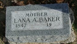
Lana A Hulse Baker
| Birth | : | 7 Jun 1847 South Bloomfield Township, Morrow County, Ohio, USA |
| Death | : | 1 Nov 1936 South Pasadena, Los Angeles County, California, USA |
| Burial | : | Old Trinity Episcopal Church Cemetery, Church Creek, Dorchester County, USA |
| Coordinate | : | 38.5040070, -76.1660580 |
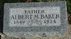
| Description | : | There is a Los Angeles, California, death index record for a Lena Baker, age 90, who died 1 November 1936. The record or certificate is no. 66798. She had resided at 808 Prospect Ave., South Pasadena. She was a widow. Her husband's name: Albert Morris Baker. Lena's date of birth was 7 June 1846 [grave marker says 1847]. She died at age 90 years, 4 months, 24 days. Place of birth: Mt. Gilead, Ohio. Father's name Will Hultz, father born in Ohio. Mother's information unknown. Informant: George Tremble. Buried in Osceola, Clarke County, Iowa, 3 November 1936, in Maple Hill... Read More |
frequently asked questions (FAQ):
-
Where is Lana A Hulse Baker's memorial?
Lana A Hulse Baker's memorial is located at: Old Trinity Episcopal Church Cemetery, Church Creek, Dorchester County, USA.
-
When did Lana A Hulse Baker death?
Lana A Hulse Baker death on 1 Nov 1936 in South Pasadena, Los Angeles County, California, USA
-
Where are the coordinates of the Lana A Hulse Baker's memorial?
Latitude: 38.5040070
Longitude: -76.1660580
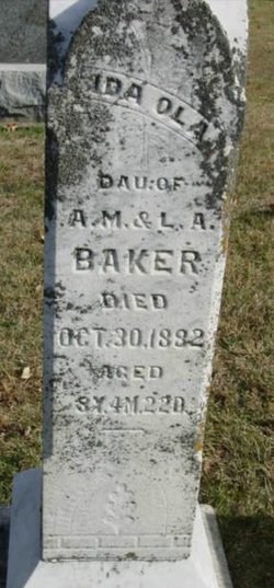
Family Members:
Parent
Spouse
Siblings

Children
Flowers:


Nearby Cemetories:
1. Old Trinity Episcopal Church Cemetery
Church Creek, Dorchester County, USA
Coordinate: 38.5040070, -76.1660580
2. Old Field Cemetery
Cambridge, Dorchester County, USA
Coordinate: 38.4918870, -76.1324520
3. Harrisville Malone Cemetery
Harrisville, Dorchester County, USA
Coordinate: 38.4914100, -76.2169200
4. Joppa Cemetery
Madison, Dorchester County, USA
Coordinate: 38.5078011, -76.2200012
5. Gethsemane-Madison Cemetery
Madison, Dorchester County, USA
Coordinate: 38.5076000, -76.2210600
6. Antioch Cemetery
Dorchester County, USA
Coordinate: 38.5494003, -76.1568985
7. Dail Graveyard
Dorchester County, USA
Coordinate: 38.5487887, -76.1250697
8. Christ Rock United Methodist Church Cemetery
Cambridge, Dorchester County, USA
Coordinate: 38.5443878, -76.1030884
9. Windemere Cemetery
Cambridge, Dorchester County, USA
Coordinate: 38.5811500, -76.1713400
10. Blackwater National Wildlife Refuge Cemetery
Church Creek, Dorchester County, USA
Coordinate: 38.4239450, -76.1752370
11. Greenlawn Cemetery
Cambridge, Dorchester County, USA
Coordinate: 38.5694008, -76.1035995
12. Old Hughes Mission Cemetery
Bucktown, Dorchester County, USA
Coordinate: 38.4694621, -76.0698920
13. Bethel Cemetery
Cambridge, Dorchester County, USA
Coordinate: 38.5583000, -76.0847015
14. George H. Applegarth Farm Cemetery
Cornersville, Dorchester County, USA
Coordinate: 38.5634000, -76.2442100
15. Frank North Farm Cemetery
Cambridge, Dorchester County, USA
Coordinate: 38.5690983, -76.2387542
16. Waugh Cemetery
Cambridge, Dorchester County, USA
Coordinate: 38.5657997, -76.0832977
17. Smithville Cemetery
Smithville, Dorchester County, USA
Coordinate: 38.4740000, -76.2753700
18. Cambridge Cemetery
Cambridge, Dorchester County, USA
Coordinate: 38.5657997, -76.0757980
19. Beckwith Cemetery
Hudson, Dorchester County, USA
Coordinate: 38.5937470, -76.2018590
20. Stoney Point Graveyard - Neck District
Lloyds, Dorchester County, USA
Coordinate: 38.5998000, -76.1761500
21. Woolford Graves
Cambridge, Dorchester County, USA
Coordinate: 38.5709180, -76.0760290
22. Christ Episcopal Church Cemetery
Cambridge, Dorchester County, USA
Coordinate: 38.5727997, -76.0768967
23. Brooks Creek Cemetery
Dorchester County, USA
Coordinate: 38.5549965, -76.2731628
24. Dail Farm Cemetery
Cambridge, Dorchester County, USA
Coordinate: 38.5774855, -76.2502666