
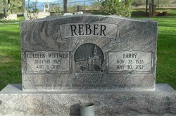
Larry Reber
| Birth | : | 28 Nov 1928 Bunkerville, Clark County, Nevada, USA |
| Death | : | 30 May 2012 Bunkerville, Clark County, Nevada, USA |
| Burial | : | Bunkerville Cemetery, Bunkerville, Clark County, USA |
| Coordinate | : | 36.7742996, -114.1182022 |
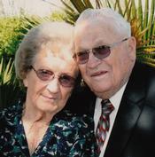
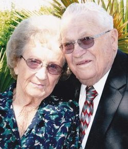
| Description | : | Larry Reber, 83, passed away Wednesday, May 30, 2012, surrounded by family at his home in Bunkerville, NV. He was born November 28, 1928 In Bunkerville, NV, to Louis Rumell and Velma Leila Waite. He married his high school sweetheart, Colleen Wittwer, May 23, 1947 in the St. George Temple. They had just celebrated their 65th wedding anniversary. Larry was raised in Littlefield, Arizona. His mother died giving birth to a younger brother when Larry was 2, so he was spoiled by a loving grandmother and many aunts. His early school years were spent in Littlefield, and he graduated from Virgin... Read More |
frequently asked questions (FAQ):
-
Where is Larry Reber's memorial?
Larry Reber's memorial is located at: Bunkerville Cemetery, Bunkerville, Clark County, USA.
-
When did Larry Reber death?
Larry Reber death on 30 May 2012 in Bunkerville, Clark County, Nevada, USA
-
Where are the coordinates of the Larry Reber's memorial?
Latitude: 36.7742996
Longitude: -114.1182022
Family Members:
Parent
Spouse
Siblings
Children

Flowers:


Nearby Cemetories:
1. Bunkerville Cemetery
Bunkerville, Clark County, USA
Coordinate: 36.7742996, -114.1182022
2. New Mesquite City Cemetery
Mesquite, Clark County, USA
Coordinate: 36.8192700, -114.1186000
3. Mesquite City Cemetery
Mesquite, Clark County, USA
Coordinate: 36.8117104, -114.0617905
4. Davidson Family Gravesite
Lincoln County, USA
Coordinate: 36.8870811, -114.2647934
5. Littlefield Cemetery
Littlefield, Mohave County, USA
Coordinate: 36.8902016, -113.9279480
6. Beaver Dam Cemetery
Mohave County, USA
Coordinate: 36.9020157, -113.9256287
7. Nay Ranch Cemetery
Riverside, Clark County, USA
Coordinate: 36.5230100, -114.0573700
8. Saint Joseph Cemetery
Logandale, Clark County, USA
Coordinate: 36.5863991, -114.4623032
9. Pioneer Hill Cemetery
Overton, Clark County, USA
Coordinate: 36.5607986, -114.4399033
10. Logandale Cemetery
Logandale, Clark County, USA
Coordinate: 36.5998993, -114.4748001
11. Saint Thomas Cemetery
Overton, Clark County, USA
Coordinate: 36.5205994, -114.4359970
12. Westpoint Cemetery
Moapa, Clark County, USA
Coordinate: 36.6645584, -114.6408768
13. Moapa Paiute Indian Cemetery
Moapa, Clark County, USA
Coordinate: 36.6613007, -114.6594009
14. Clark Memorial
Overton, Clark County, USA
Coordinate: 36.4253880, -114.4690970
15. Warm Springs Cemetery
Moapa, Clark County, USA
Coordinate: 36.7079010, -114.6985016
16. Warm Spring Ranch Burial Site
Moapa, Clark County, USA
Coordinate: 36.7114840, -114.7135450
17. Shivwits Cemetery
Washington County, USA
Coordinate: 37.1825981, -113.7650986
18. Gold Butte Cemetery
Clark County, USA
Coordinate: 36.2802505, -114.1996994
19. Shepherd of the Hills UMC Memorial Garden
Saint George, Washington County, USA
Coordinate: 37.0734030, -113.6039450
20. Tonaquint Cemetery
Saint George, Washington County, USA
Coordinate: 37.0789986, -113.6011963
21. Santa Clara Cemetery
Santa Clara, Washington County, USA
Coordinate: 37.1408005, -113.6667023
22. Ivins City Cemetery
Ivins, Washington County, USA
Coordinate: 37.1750984, -113.6834030
23. Grace Episcopal Church Rose Garden
Saint George, Washington County, USA
Coordinate: 37.0921350, -113.5607433
24. Saint George City Cemetery
Saint George, Washington County, USA
Coordinate: 37.1068993, -113.5686035