

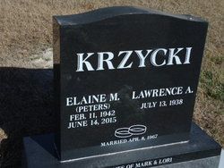
Lawrence A. “Larry” Krzycki
| Birth | : | 13 Jul 1938 Genoa, Nance County, Nebraska, USA |
| Death | : | 22 Dec 2019 Omaha, Douglas County, Nebraska, USA |
| Burial | : | Saint Josaphats Cemetery, Loup City, Sherman County, USA |
| Coordinate | : | 41.3022003, -98.9847031 |
| Description | : | Lawrence “Larry” Krzycki, 81 of Omaha, NE, formerly of Loup City, NE died Sunday, December 22, 2019 at the VA Medical Center in Omaha, NE. Mass of Christian Burial will be 10:30 a.m. Saturday, December 28, 2019 at St. Josaphat’s Catholic Church in Loup City. Father Scott Harter will celebrate the Mass. Military honors will follow Mass and will be provided by the Loup City American Legion Post #48. Cremation will follow with inurnment of the ashes to be at a later date at the Evergreen Cemetery in Loup City. Visitation will be from 5:00 p.m. to 7:00 p.m. Friday,... Read More |
frequently asked questions (FAQ):
-
Where is Lawrence A. “Larry” Krzycki's memorial?
Lawrence A. “Larry” Krzycki's memorial is located at: Saint Josaphats Cemetery, Loup City, Sherman County, USA.
-
When did Lawrence A. “Larry” Krzycki death?
Lawrence A. “Larry” Krzycki death on 22 Dec 2019 in Omaha, Douglas County, Nebraska, USA
-
Where are the coordinates of the Lawrence A. “Larry” Krzycki's memorial?
Latitude: 41.3022003
Longitude: -98.9847031
Family Members:
Parent

Spouse

Flowers:


Nearby Cemetories:
1. Saint Josaphats Cemetery
Loup City, Sherman County, USA
Coordinate: 41.3022003, -98.9847031
2. Evergreen Cemetery
Loup City, Sherman County, USA
Coordinate: 41.2997017, -98.9852982
3. Sunny Slope Cemetery
Loup City, Sherman County, USA
Coordinate: 41.2906000, -99.0267000
4. Cleoria Cemetery
Loup City, Sherman County, USA
Coordinate: 41.2779000, -99.0893500
5. Balsora Cemetery
Sherman County, USA
Coordinate: 41.3782997, -99.0975037
6. Austin Cemetery
Rockville, Sherman County, USA
Coordinate: 41.1880989, -98.8981018
7. Verdurette Cemetery
Sherman County, USA
Coordinate: 41.1697006, -98.9757996
8. Davis Creek Cemetery
Valley County, USA
Coordinate: 41.4219017, -98.9052963
9. Saint Francis Cemetery
Ashton, Sherman County, USA
Coordinate: 41.2438000, -98.7994000
10. Lone Elm Cemetery
Loup City, Sherman County, USA
Coordinate: 41.2921982, -99.1864014
11. Immanuel Lutheran Cemetery
Ashton, Sherman County, USA
Coordinate: 41.2140000, -98.8142000
12. Arcadia Cemetery
Arcadia, Valley County, USA
Coordinate: 41.4237000, -99.1167000
13. Gray Cemetery
Sherman County, USA
Coordinate: 41.2099991, -99.1567001
14. Pleasant Hill Friends Cemetery
Valley County, USA
Coordinate: 41.4230800, -98.8377700
15. Dunkard Cemetery
Arcadia, Valley County, USA
Coordinate: 41.4522000, -99.0769000
16. Union Cemetery
Ashton, Sherman County, USA
Coordinate: 41.2214012, -98.7855988
17. Litchfield Cemetery
Litchfield, Sherman County, USA
Coordinate: 41.1543999, -99.1283035
18. Mount Carmel Cemetery
Howard County, USA
Coordinate: 41.2797012, -98.7328033
19. Salem Evangelical Church Cemetery
Ord, Valley County, USA
Coordinate: 41.4902992, -98.9244003
20. Lewis Burial Plat
Litchfield, Sherman County, USA
Coordinate: 41.1383000, -99.1484000
21. Lee Park Cemetery
Custer County, USA
Coordinate: 41.4025002, -99.2307968
22. Trinity Lutheran Church Cemetery
Hazard, Sherman County, USA
Coordinate: 41.0913000, -99.0052000
23. Lee Park Catholic Cemetery
Westerville, Custer County, USA
Coordinate: 41.4091988, -99.2311020
24. Dannevirke Cemetery
Dannevirke, Howard County, USA
Coordinate: 41.3227997, -98.6986008