
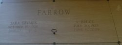
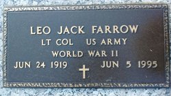
Lawrence Bruce Farrow
| Birth | : | 20 Jul 1923 Greenville County, South Carolina, USA |
| Death | : | 11 Jun 2009 South Carolina, USA |
| Burial | : | St. Peter and St. Paul's Churchyard, Muchelney, South Somerset District, England |
| Coordinate | : | 51.0207389, -2.8154595 |
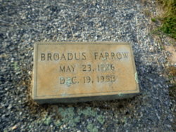
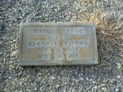
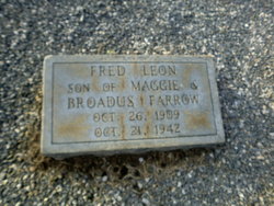
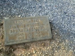
| Description | : | L. Bruce Farrow, 85, husband of Sara Crymes Farrow for 58 years, died Thursday, June 11, 2009. Mr. Farrow was born July 20, 1923, in Greenville County to the late Broadus Farrow and Maggie Young Farrow. He was a co-owner of Quality Builders Supply & Hardware and was an alumnus of Cecils Business College. He was a member of First Baptist Church of Fountain Inn, where he taught the B.C. Givens Sunday School Class for over 40 years. He also formerly served as a Deacon. He was a member of Gideon's International, and was a 50-year member of the Fountain Inn... Read More |
frequently asked questions (FAQ):
-
Where is Lawrence Bruce Farrow's memorial?
Lawrence Bruce Farrow's memorial is located at: St. Peter and St. Paul's Churchyard, Muchelney, South Somerset District, England.
-
When did Lawrence Bruce Farrow death?
Lawrence Bruce Farrow death on 11 Jun 2009 in South Carolina, USA
-
Where are the coordinates of the Lawrence Bruce Farrow's memorial?
Latitude: 51.0207389
Longitude: -2.8154595
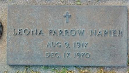
Family Members:
Parent
Spouse

Siblings
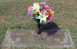
Flowers:


Nearby Cemetories:
1. St. Peter and St. Paul's Churchyard
Muchelney, South Somerset District, England
Coordinate: 51.0207389, -2.8154595
2. Blessed Virgin Mary Churchyard
Huish Episcopi, South Somerset District, England
Coordinate: 51.0362250, -2.8182410
3. All Saints Churchyard
Langport, South Somerset District, England
Coordinate: 51.0369970, -2.8254530
4. St. Catherine's Churchyard
Drayton, South Somerset District, England
Coordinate: 51.0191860, -2.8494960
5. Langport Cemetery
Langport, South Somerset District, England
Coordinate: 51.0426200, -2.8244600
6. Curry Rivel Cemetery
Curry Rivel, South Somerset District, England
Coordinate: 51.0257667, -2.8676226
7. St. Andrew's Churchyard
Curry Rivel, South Somerset District, England
Coordinate: 51.0246570, -2.8687410
8. St. Martin's Churchyard
Kingsbury Episcopi, South Somerset District, England
Coordinate: 50.9863950, -2.8043130
9. St John the Baptist Churchyard
Pitney, South Somerset District, England
Coordinate: 51.0532200, -2.7937320
10. Long Sutton Friends Burial Ground
Long Sutton, South Somerset District, England
Coordinate: 51.0302700, -2.7612300
11. Christ Church Cemetery
Long Load, South Somerset District, England
Coordinate: 51.0054700, -2.7639100
12. Holy Trinity Churchyard
Long Sutton, South Somerset District, England
Coordinate: 51.0246110, -2.7577940
13. Low Ham Church in the Field
High Ham, South Somerset District, England
Coordinate: 51.0583449, -2.8155268
14. Saint Andrew's Churchyard
Aller, South Somerset District, England
Coordinate: 51.0554000, -2.8627000
15. St. James the Less Churchyard
Hambridge, South Somerset District, England
Coordinate: 50.9849380, -2.8669180
16. High Ham Cemetery
High Ham, South Somerset District, England
Coordinate: 51.0739931, -2.8216351
17. Ash Parish Cemetery
Ash, South Somerset District, England
Coordinate: 50.9833540, -2.7538380
18. Holy Trinity Churchyard
Ash, South Somerset District, England
Coordinate: 50.9834250, -2.7528400
19. St. Catherine's Churchyard
Fivehead, South Somerset District, England
Coordinate: 51.0083009, -2.9000973
20. St. Andrew's Churchyard
High Ham, South Somerset District, England
Coordinate: 51.0760320, -2.8218400
21. St James Churchyard
Kingsbury Episcopi, South Somerset District, England
Coordinate: 50.9646420, -2.8106370
22. All Saints Churchyard
Martock, South Somerset District, England
Coordinate: 50.9692420, -2.7687860
23. All Saints Churchyard
Isle Brewers, South Somerset District, England
Coordinate: 50.9854450, -2.9000040
24. United Reform Churchyard
Martock, South Somerset District, England
Coordinate: 50.9609320, -2.7735020